
Gary · @empiricism
209 followers · 614 posts · Server ecoevo.social
Rhododendron #flowers in the Carpathian Mountains, Carpathian National Nature Park, #Ukraine ( Wikimedia Commons)
#flowers #ukraine #nature #ecosystem #landscapeecology

Jakub Nowosad · @nowosad
756 followers · 108 posts · Server fosstodon.org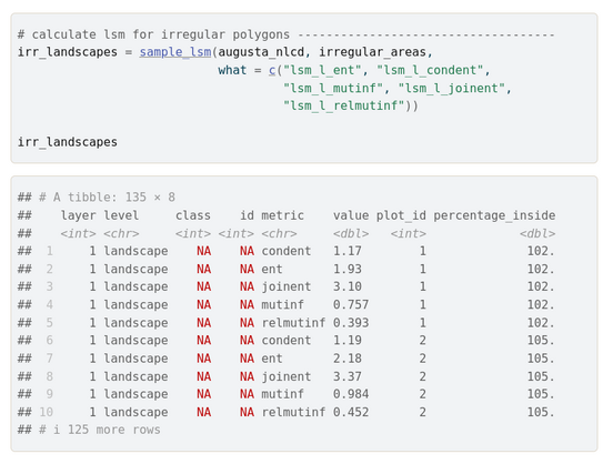
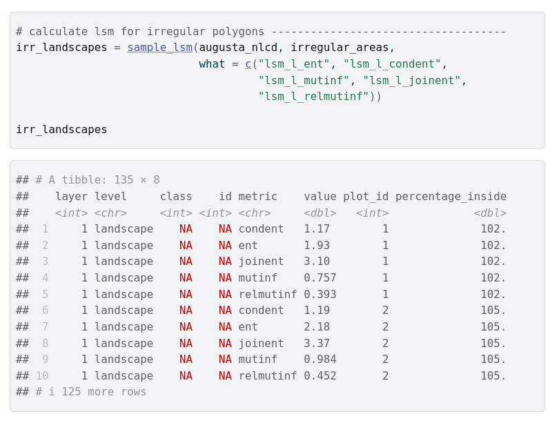
🔔 The landscapemetrics package series:🔔
A brand new vignette!
Calculating landscape metrics for irregular areas --- read more at https://r-spatialecology.github.io/landscapemetrics/articles/irregular_areas.html.
#rstats #rspatial #landscapeecology
Jakub Nowosad · @nowosad
752 followers · 105 posts · Server fosstodon.org
🔔 The landscapemetrics package series:🔔
Utility functions --- read more at https://r-spatialecology.github.io/landscapemetrics/articles/utility.html .
#rstats #rspatial #landscapeecology
Jakub Nowosad · @nowosad
748 followers · 102 posts · Server fosstodon.org
🔔 The landscapemetrics package series:🔔
Landscape distribution statistics --- read more at https://r-spatialecology.github.io/landscapemetrics/articles/landscape_distribution_statistics.html .
#rstats #rspatial #landscapeecology
Jakub Nowosad · @nowosad
745 followers · 98 posts · Server fosstodon.org
🔔 The landscapemetrics package series:🔔
Sampling around points of interest --- read more at https://r-spatialecology.github.io/landscapemetrics/articles/guide_sample_lsm.html .
#rstats #rspatial #landscapeecology

Chuixiang (Tree) Yi · @TreeYi
9 followers · 3650 posts · Server mastodon.world
RT @nezampieri
Please RT and share! Our lab is looking for a research technician 🔥🌳 #Ecology #LandscapeEcology #EarthMonth #Jobs https://twitter.com/JefferyBCannon/status/1641772342660440064
#ecology #landscapeecology #earthmonth #jobs
Alexandra-Maria Klein · @naturealexk
352 followers · 160 posts · Server freiburg.social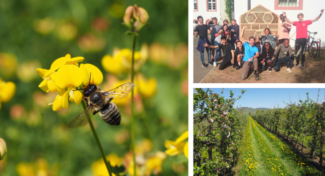
Together we work on #PollinationEcology🐝 🌼 #MultiTrophicInteractions🐜🌿 #BiodiversityConservation🌍 #AgroEcology👨🌾 🌽 #LandscapeEcology🌳🌸 #CitizenScience🧪 🤝 https://www.nature.uni-freiburg.de/research
#pollinationecology #multitrophicinteractions #biodiversityconservation #agroecology #landscapeecology #citizenscience
Alexandra-Maria Klein · @naturealexk
352 followers · 159 posts · Server freiburg.social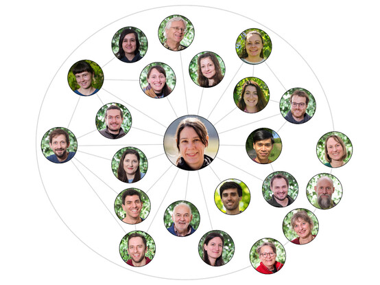
Meet our amazing & well connected team of researchers & lecturers of the #NatureConservation & #LandscapeEcology group🌳 🌸@unifreiburg. Every Wednesday, I will present one of our scientists #NatureScientistsUFR👩🔬 👨🔬 https://www.nature.uni-freiburg.de/team-en/Team_en?set_language=en
#natureconservation #landscapeecology #naturescientistsufr
Jakub Nowosad · @nowosad
742 followers · 97 posts · Server fosstodon.org
🔔 The landscapemetrics package series:🔔
Moving window --- read more at https://r-spatialecology.github.io/landscapemetrics/articles/guide_moving_window.html .
#rstats #rspatial #landscapeecology
Jakub Nowosad · @nowosad
741 followers · 94 posts · Server fosstodon.org
🔔 The landscapemetrics package series:🔔
General background --- read more about it at https://r-spatialecology.github.io/landscapemetrics/articles/general_background.html .
#rstats #rspatial #landscapeecology
Trevor Caughlin · @trevorcaughlin
384 followers · 113 posts · Server ecoevo.socialSo excited to be at my favorite academic meeting for the week! @iale_na #landscapeecology

Dynafor · @dynafor
36 followers · 32 posts · Server social.sciences.re
[#Publication] 📰just out 📢"A new method for quantifying treeline-ecotone change based on multiple spatial pattern dimensions"🌲🌳 in #LandscapeEcology with contribution from colleague @sheeren_david @ENSAT_INP
https://link.springer.com/article/10.1007/s10980-022-01589-4
#publication #landscapeecology

Gary · @empiricism
277 followers · 1511 posts · Server qoto.orgWe need better tools to understand, conceptualise & perceive ecological related data.
I'm thinking something similar to Google Earth - though for climate \ ecology information. Ecology Earth - The planets biosphere.
A map should display two objective properties:
1) A local region's air pollution emissions (e.g., Greenhouse gases, Carbon particle emissions << the two are positively correlated)
2. A local region's landscape ecological quality.
However, such a world map will require a significant amount of time to develop - to collect the information from the relevant databases.
The data for (1) can be citizens air pollution monitors (e.g., low cost[ish] air pollution monitors - do measure carbon particles, are already installed & networked. In many locations) and satellite data. https://essp.nasa.gov/tag/air-pollution/
https://www.nasa.gov/feature/langley/nasa-air-pollution-instrument-completes-satellite-integration
The data for (2) can be the scientists (e.g., ecologists) assessment of the local eco-landscapes condition.
For example, where l live, the general eco-condition is "sheep wrecked" and "air polluted". Due to the "normal" daily activities of the local farmers, many local people, etc.
So, the Ecological Earth map can be a combination of scientific data & citizen science data.
We have to change our ways (methods, activities, behaviours) to mitigate climate change. That means "old" habits must change or "old" habits will die hard.
#science #CitizenScience #climate #GlobalHeating #ClimateChange #ecology #landscapeEcology #data #ClimateAction #politics #EcoPolicy
#science #citizenscience #climate #globalheating #EcoPolicy #data #climateaction #politics #climatechange #ecology #landscapeecology
Gary · @empiricism
277 followers · 1511 posts · Server qoto.orgWe need better tools to understand, conceptualise & perceive ecological related data.
I'm thinking something similar to Google Earth - though for climate \ ecology information. Ecology Earth - The planets biosphere.
A map should display two objective properties:
1) A local region's air pollution emissions (e.g., Greenhouse gases, Carbon particle emissions << the two are positively correlated)
2. A local region's landscape ecological quality.
However, such a world map will require a significant amount of time to develop - to collect the information from the relevant databases.
The data for (1) can be citizens air pollution monitors (e.g., low cost[ish] air pollution monitors do measure carbon particles are already installed & networked. In many locations) and satellite data. https://essp.nasa.gov/tag/air-pollution/
https://www.nasa.gov/feature/langley/nasa-air-pollution-instrument-completes-satellite-integration
The data for (2) can be the scientists (e.g., ecologists) assessment of the local eco-landscapes condition.
For example, where l live, the general eco-condition is "sheep wrecked" and "air polluted". Due to "normal" daily activities of the local farmers, many local people, etc.
So, the Ecological Earth map can be a combination of scientific data & citizen science data.
We have to change our ways (methods, activities, behaviours) to mitigate climate change. That means "old" habits must change or "old" habits will die hard.
#science #CitizenScience #climate #GlobalHeating #ClimateChange #ecology #landscapeEcology #data #ClimateAction #politics #EcoPolicy
#citizenscience #climate #globalheating #climatechange #ecology #landscapeecology #data #climateaction #politics #EcoPolicy #science
Gary · @empiricism
277 followers · 1511 posts · Server qoto.orgWe need better tools to understand, conceptualise & perceive ecological related data.
I'm thinking something similar to Google Earth - though for climate \ ecology information. Ecology Earth - The planets biosphere.
A map should display two objective properties:
1) A local region's air pollution emissions (e.g., Greenhouse gases, Carbon particle emissions << the two are positively correlated)
2. A local region's landscape ecological quality.
However, such a world map will require a significant amount of time to develop - to collect the information from the relevant databases.
The data for (1) can be citizens air pollution monitors (e.g., low cost[ish] air pollution monitors do measure carbon particles) and satellite data. https://essp.nasa.gov/tag/air-pollution/
https://www.nasa.gov/feature/langley/nasa-air-pollution-instrument-completes-satellite-integration
The data for (2) can be the scientists (e.g., ecologists) assessment of the local eco-landscapes condition.
For example, where l live, the general eco-condition is "sheep wrecked" and "air polluted". Due to "normal" daily activities of the local farmers, many local people, etc.
So, the Ecological Earth map can be a combination of scientific data & citizen science data.
We have to change our ways (methods, activities, behaviours) to mitigate climate change. That means "old" habits must change or "old" habits will die hard.
#science #CitizenScience #climate #GlobalHeating #ClimateChange #ecology #landscapeEcology #data #ClimateAction #politics #EcoPolicy
#science #citizenscience #climate #globalheating #climateaction #climatechange #data #EcoPolicy #ecology #landscapeecology #politics
Gary · @empiricism
277 followers · 1511 posts · Server qoto.orgWe need better tools to understand, conceptualise & perceive ecological related data.
I'm thinking something similar to Google Earth - though for climate \ ecology information. Ecology Earth - The planets biosphere.
A map should display two objective properties:
1) A local region's air pollution emissions (e.g., Greenhouse gases, Carbon particle emissions << the two are positively correlated)
2. A local region's landscape ecological quality.
However, such a world map will require a significant amount of time to develop - to collect the information from the relevant databases.
The data for (1) can be citizens air pollution monitors (e.g., cheap air pollution monitor measure carbon particles) and satellite data. https://essp.nasa.gov/tag/air-pollution/
https://www.nasa.gov/feature/langley/nasa-air-pollution-instrument-completes-satellite-integration
The data for (2) can be the scientists (e.g., ecologists) assessment of the local eco-landscapes condition.
For example, where l live, the general eco-condition is "sheep wrecked" and "air polluted". Due to "normal" daily activities of the local farmers, many local people, etc.
So, the Ecological Earth map can be a combination of scientific data & citizen science data.
We have to change our ways (methods, activities, behaviours) to mitigate climate change. That means "old" habits must change or "old" habits will die hard.
#science #CitizenScience #climate #GlobalHeating #ClimateChange #ecology #landscapeEcology #data #ClimateAction #politics #EcoPolicy
#science #citizenscience #climate #globalheating #climatechange #ecology #landscapeecology #climateaction #politics #EcoPolicy #data
Zsófia Horváth · @zsofia_horvath
32 followers · 3 posts · Server ecoevo.socialI am a community ecologist at #CentreforEcologicalResearch #CER in #Hungary, interested in #metacommunities #spatialecology #landscapeecology #connectivity #biodiversity #salinity #dispersal
Guest researcher at #KULeuven
Formerly #WasserClusterLunz #WCL
My lab combines #experimental work (mostly #mesocosms) and #empirical studies. Recently also into #eDNA and #citizenscience
I am part of the #aquacosm community and doing lots of research on #ponds
#centreforecologicalresearch #cer #hungary #metacommunities #SpatialEcology #landscapeecology #connectivity #biodiversity #salinity #dispersal #kuleuven #wasserclusterlunz #wcl #experimental #mesocosms #empirical #eDNA #citizenscience #aquacosm #ponds #epcn #sil #aslo #mypond

Karolina Argote · @KarolinaArgote
2 followers · 1 posts · Server ecoevo.social
👩🏾🔬 A typical lab-day at @imbe building artificial mini-landscapes to study the response of microarthropods #collembola to #habitatloss & #fragmentation. The results that are coming out are amazing!! 🔥
#Collembola #HabitatLoss #fragmentation #phdlife #landscapeecology #springtails #SoilBiodiversity

unearth · @unearth
18 followers · 68 posts · Server mastodon.nz
Some of my work is industrial planting & terrain design / management (a longterm goal).
Here I'm helping rehabilitate a post-mine site, this means interpreting many legal documents, much drawing & modelling, then planting orders (and sometimes research), earthworks & time getting to know my site and all the people in and around it.
#Otago #NewZealand #PlantingDesign #LandscapeEcology #RestorationEcology
#otago #newzealand #plantingdesign #landscapeecology #restorationecology
Gary · @empiricism
181 followers · 607 posts · Server qoto.org
An impressive view in the Lake District National park (10/12/22), Cumbria, UK. The valley below is called St. Johns in the vale.
However, there is nothing saintly about the valley.
The valley below is in a (generally) "sheep-wrecked" condition - ecologically degraded and drained farmland. The majority of standing trees in the area are conifer tree plantations.
All the farms in the valley burn woodfuel & or coal to heat their homes. Many people in the nearby villages burn woodfuel & coal to heat their homes. Many of their homes are poorly insulated - drafty old buildings that take a lot of energy to heat during the winter.
Approximately 30 km South West (To the right & over the distant mountains) is the town of #Whitehaven. Whitehaven is where the UK's #government (The #Conservative Party) is planning to open a coal mine.
Some people have said, to paraphrase "what will they do with this coal? because many steel manufacturers are converting to electrical methods!".
The government (in partnership with their industrial associates) will sell some of the coal to the local people of Cumbria - people who heat their houses using victorian age technologies. That's not because they're forward-looking people. And that's why they vote for the outdated forms of, fossil fuel promoting, "business as usual", ecocidal politics.
However, the truth (evidence), has the potential to liberate the local communities. To clear up their local air and have affordable electricity so as to heat their (modernized) homes (e.g., using heat pumps)
#climate #UK #cumbria #ecology #LandscapeEcology #hiking #photography #CloudInversion #mountains
#Culture #traditional #politics #farming #SheepWrecked #tourism #FossilFuels #WoodFuels oil #gas #Deforested
#ClimateAction #HomeInsulation #rebuilds #renewables #HeatPumps #EcologicalRestoration #rewilding
#whitehaven #government #conservative #SheepWrecked #tourism #fossilfuels #WoodFuels #gas #deforested #climateaction #HomeInsulation #rebuilds #renewables #ecologicalrestoration #climate #uk #cumbria #ecology #landscapeecology #hiking #photography #cloudinversion #mountains #culture #traditional #politics #farming #heatpumps #rewilding