
HalifaxShippingNews · @hfxshippingnews
69 followers · 6 posts · Server halifaxsocial.ca
Day 22 - Null. Plugged and Abandoned offshore oil wells off Nova Scotia. #30DaysMapChallenge
HalifaxShippingNews · @hfxshippingnews
63 followers · 5 posts · Server halifaxsocial.ca
Day 21 - Kontur Population Dataset. Where the Canadians Live. #30DaysMapChallenge

Colpizen · @Colpizen
352 followers · 351 posts · Server mastodon.social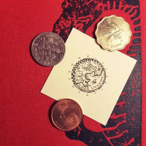
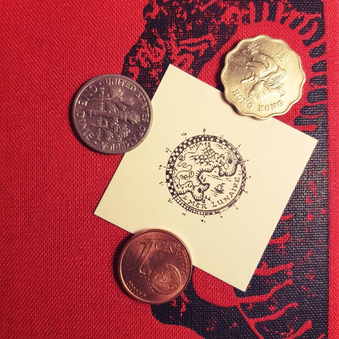
#30DaysMapChallenge Day 17: a map without a computer.
Je fais pas le challenge mais pas pu m'empêcher :)
#cartography #sciart
#30daysmapchallenge #cartography #sciart
Colpizen · @Colpizen
500 followers · 997 posts · Server mastodon.social#30DaysMapChallenge Day 17: a map without a computer.
Je fais pas le challenge mais pas pu m'empêcher :)
#cartography #sciart
#30daysmapchallenge #cartography #sciart

Digital Geography Lab · @digigeolab
117 followers · 106 posts · Server mastodon.online
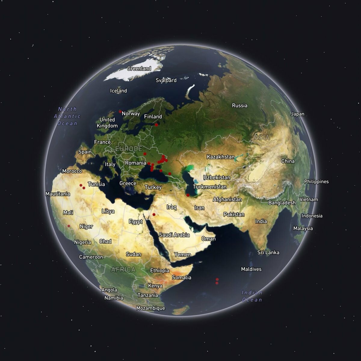
#30DaysMapChallenge Day 19 'Globe'
@oleksa_karasov@twitter.com mapped the last 100 mentions of @GeoConfirmed@twitter.com - predominantly geolocated events of the Russian invasion of Ukraine. Data retrieval: script by @DavidNewschool@twitter.com; software: amazing @Mapbox@twitter.com Studio

Gregor · @dataschrat
19 followers · 33 posts · Server sigmoid.socialIn really like challenges such as #30daysmapchallenge and #adventofcode.
Are there similar challenges in the area of #DataScience #ml #ai? I think it is a great way to get your feet wet in a certain topic.
#30daysmapchallenge #adventofcode #DataScience #ml #ai

Anita Graser 🇪🇺🇺🇦 · @underdarkGIS
1317 followers · 171 posts · Server fosstodon.org@brindavoine @miskaknapek not as much as a on 🐦 yet, but hey: just start using #30DaysMapChallenge and #GISchat and it will grow

Jakub Nowosad · @nowosad
320 followers · 21 posts · Server fosstodon.org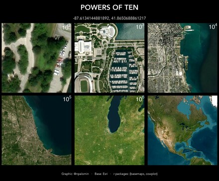
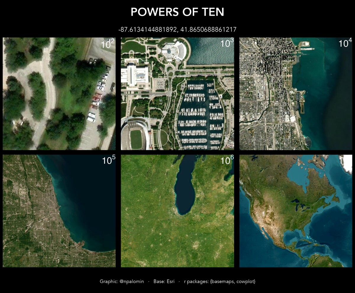
RT @npalomin: #30daysmapchallenge day 12 - Scale
Powers of 10. Inspired by the film by Charles and Ray Eames (1977). Snapshots of side 10^2 to 10^7.
Chicago (original location)
#30daysmapchallenge #rspatial #rstats
ranska · @ranska
15 followers · 37 posts · Server piaille.fr
Angus Miller · @geowalks
70 followers · 21 posts · Server mastodon.scot
RT @seismo_amy@twitter.com
Today's theme for the #30DaysMapChallenge is Red so here's a map showing Scottish hills with red in their name. Plenty of Gaelic ones (Dearg/Ruadh) but interestingly none in English (Red) or Scots/Doric (Reid). They are plotted on top of a geological map showing red-ish rocks...
🐦🔗: https://twitter.com/seismo_amy/status/1591044586692284416

Lino Galiana · @linogaliana
33 followers · 17 posts · Server vis.social
#30DaysMapChallenge Day10 : bad map (projection)
Projections are tricky to understand when starting to work on spatial data. An example for France: this one (epsg: 5070) should be reserved to North America, not France !
Example from my python course
pythonds.linogaliana.fr/geopandas/

Raf · @Raf
298 followers · 5913 posts · Server mastodon.social
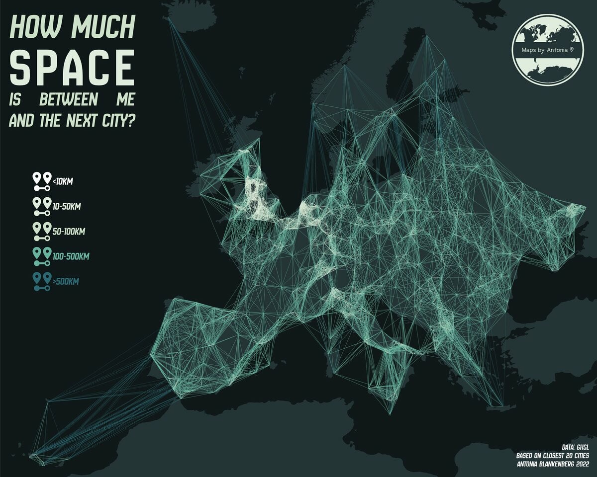
RT @MapsByAntonia@twitter.com
Today's #30DaysMapChallenge theme is Space!
This map is heavily inspired by one of @HeatherCh100@twitter.com's maps from last year which highlights the space between urban centres
🐦🔗: https://twitter.com/MapsByAntonia/status/1590278138093010950

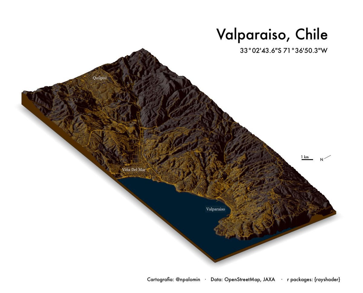
Jesus M. Castagnetto🇵🇪💉x4 · @jmcastagnetto
52 followers · 781 posts · Server mastodon.social
RT @npalomin@twitter.com
#30daysmapchallenge day 7 - Raster
Valparaiso is the second most populated urban agglomeration in Chile. Formerly, a vital stopover port until the opening of the Panama Canal (Digital Elevation Model 30m)
#30daysmapchallenge #rspatial #rstats

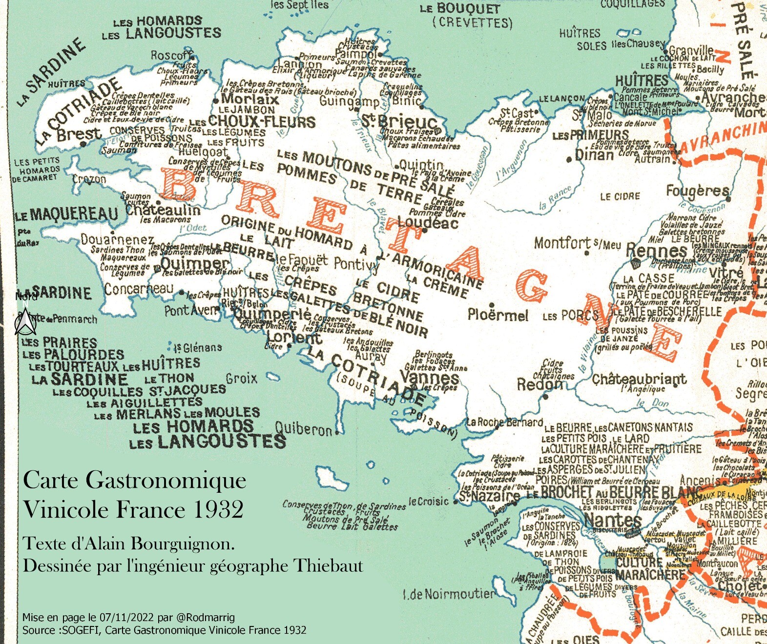
Rodmarrig · @Rodmarrig
83 followers · 20 posts · Server mapstodon.space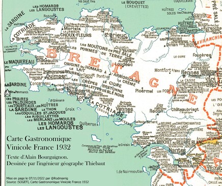
Pouf !
Encore la #Bretagne, et dans cette image recalée pleine de clichés de 1932, la frontière de notre région est bien nette et très belle🥰
Pour ce #30daysmapchallenge , le thème du jour est "Raster" (pour les moldus, des images fixes: une photo aérienne par exemple)
A demain!
Still #Brittany, and in this recalibrated image full of cliché from 1932, the border of our region is clear and so nice 🥰
For this day, the theme is "Raster" (for muggles, an image: an aerial photo for example)
#bretagne #30daysmapchallenge #Brittany

Bill Dollins · @geobabbler
352 followers · 257 posts · Server mastodon.cloud
Here's a fairly silly map for #30DaysMapChallenge. If you have a craving for crustaceans in my part of the world, there is no shortage of places to satisfy it. #gischat

Michel Briand · @michelbriand
608 followers · 500 posts · Server framapiaf.org
RT @Rodmarrig@twitter.com
Bon bah aller, on tente au moins la première journée de ce #30daysmapchallenge avec une carte en speed sur les points !
Une carte de la construction neuve de logements en #Bretagne sur les 5 dernières années, à la section cadastrale🙂
🐦🔗: https://twitter.com/Rodmarrig/status/1587573481062932483