GregCocks · @GregCocks
612 followers · 555 posts · Server techhub.socialASPRS Approves Edition 2 of the ASPRS Positional Accuracy Standards for Digital Geospatial Data
--
https://www.asprs.org/revisions-to-the-asprs-positional-accuracy-standards-for-geospatial-data-2023 <-- shared technical article
--
https://publicdocuments.asprs.org/PositionalAccuracyStd-Ed2-V1 <-- download the current ASPRS current document
--
#GIS #spatial #mapping #gischat #ASPRS #precision #accuracy #standards #data #spatialdata #PositionalAccuracyStandards #survey #surveying #workinggroup #confidencelevel #metrics #measurement #checkpoints #groundcontrol #VWA #remotesensing #LiDAR #3dmapping #UAS #photogrammetry #geomorphometry
#gis #spatial #mapping #gischat #asprs #precision #accuracy #Standards #data #spatialdata #positionalaccuracystandards #survey #surveying #workinggroup #confidencelevel #metrics #measurement #checkpoints #groundcontrol #vwa #remotesensing #lidar #3dmapping #uas #photogrammetry #geomorphometry
GregCocks · @GregCocks
609 followers · 553 posts · Server techhub.socialA New, Underground Atlas Of Subduction Zones [EOS]
--
https://eos.org/articles/a-new-underground-atlas-of-subduction-zones <-- shared technical article
--
https://submap.gm.umontpellier.fr/ <-- Submap, a tool for mapping subduction zones
--
“Graphic design meets geoscience…
Submap is a user-friendly tool that allows anyone with an Internet connection to create quick, custom maps of subduction zones…"
#GIS #spatial #mapping #visual #visualisation #visualization #subduction #geology #structuralgeology #Submap #geoscience #global #earth #platetectonics #subductionzones #earthquake #model #modeling #3dmapping #3dmodeling #opensource #opendata #tsunami #monitoring #fault #faulting #VisualizationTools #maps #crosssections
#gis #spatial #mapping #visual #visualisation #visualization #subduction #geology #structuralgeology #submap #geoscience #global #earth #platetectonics #subductionzones #earthquake #model #modeling #3dmapping #3dmodeling #opensource #opendata #tsunami #monitoring #fault #faulting #visualizationtools #Maps #crosssections
GregCocks · @GregCocks
604 followers · 545 posts · Server techhub.socialGround-Penetrating Radar Used To Map Critically Endangered Northern Hairy-Nosed Wombat Burrows [Australia]
--
https://www.abc.net.au/news/2023-08-28/high-tech-radars-map-northern-hairy-nosed-wombat-burrows/102760896 <-- shared media article
--
https://youtu.be/OFD4S7F6MY8?si=8zTSNTPscbD_zj_U <-- shared media video
--
#GIS #spatial #mapping #remotesensing #groundpenetratingradar #GPR #ecosystem #wildlife #wildlifeconservation #Australia #wombat #marsupial #herbivore #burrow #burrows #map #3dmapping #conservation #conservationefforts #endangeredspecies #outback #scrub #grasslands #australianwildlife #SubsurfaceMappingSolutions #AustralianWildlifeConservancy
#gis #spatial #mapping #remotesensing #groundpenetratingradar #gpr #ecosystem #wildlife #WildlifeConservation #Australia #wombat #marsupial #herbivore #burrow #burrows #map #3dmapping #Conservation #conservationefforts #endangeredspecies #outback #scrub #grasslands #australianwildlife #subsurfacemappingsolutions #australianwildlifeconservancy
GregCocks · @GregCocks
599 followers · 541 posts · Server techhub.socialSunRISE – NASA’s Mission To Study Solar Activity
--
https://www.jpl.nasa.gov/missions/sun-radio-interferometer-space-experiment <-- mission’s home page
--
#GIS #spatial #mapping #extraterrestrial #space #solarsystem #sun #solar #spaceweather #CME #solarmaxium #DeepSpaceNetwork #satellite #SunRISE #NASA #JPL #cubesat #opendata #solaractivity #solarrisk #monitoring #model #modeling #3dmapping #Interferometer #Space #Experiment #radioemissions #radiation #impacts #magnetic #magnetism #particlestorm #research #solarparticlestorms #remotesensing
@NASA
#gis #spatial #mapping #Extraterrestrial #space #solarsystem #sun #solar #spaceweather #CME #solarmaxium #deepspacenetwork #satellite #sunrise #NASA #JPL #cubesat #opendata #solaractivity #solarrisk #monitoring #model #modeling #3dmapping #interferometer #experiment #radioemissions #radiation #impacts #magnetic #magnetism #particlestorm #research #solarparticlestorms #remotesensing
GregCocks · @GregCocks
580 followers · 520 posts · Server techhub.socialBlow-Me-Down Brook, NH – An NHD Flowline Picked ‘Randomly’
--
http://npshistory.com/brochures/saga/blow-me-down-na-1981.pdf <-- 1981 NPS guide
--
https://www.usgs.gov/3d-hydrography-program <-- USGS’s 3DHP home page
--
I am working on some hydroaddressing / network traversing technical approaches for 3DHP – and needed an example of a multisegment flowline in NHD-sourced dataset, and so ‘randomly’ got this one - Blow-Me-Down, NH, from WBD HUC4-0108.
Although we map so many flowlines (~20 million in the USA for NHD-sourced spatial data, estimated 10x that for the EDH data still to be determined across the USA), I like trying to understand what a flowline or waterbody ‘is’ to the people on the ground as much as I can...
#GIS #spatial #mapping #networktraversing #3DHP #NHD #WBD #water #hydrology #USGS #mapping #USA #elevationderivedhydrography #EDH #3denabled #3dmapping #3dmodeling #3dep #elevation #opendata #nationally #waterresources #appliedscience #newhampshire #watermanagement #watermanagement #alldataisspatial #publicdata
#gis #spatial #mapping #networktraversing #3dhp #nhd #wbd #water #hydrology #usgs #USA #elevationderivedhydrography #3denabled #3dmapping #3dmodeling #3dep #elevation #opendata #nationally #waterresources #appliedscience #newhampshire #watermanagement #alldataisspatial #publicdata #edh
GregCocks · @GregCocks
210 followers · 268 posts · Server techhub.socialSurface Water And Ocean Topography (SWOT), NASA
--
https://swot.jpl.nasa.gov/ <-- home page
--
#GIS #spatial #mapping #water #hydrology #global #opendata #openaccess #remotesensing #earthobservation #hydrospatial #SWOT #surfacewater #oceangraphy #topography #spatialanalysis #monitoring #survey #globalwater #forecasting #droughts #floods #sealevelrise #climatechange #research #3dmapping #3dmodeling #3Dmonitoring #3dscanning #3dmodel #NASA
#gis #spatial #mapping #water #hydrology #global #opendata #openaccess #remotesensing #earthobservation #hydrospatial #swot #surfacewater #oceangraphy #topography #spatialanalysis #monitoring #survey #globalwater #forecasting #droughts #floods #sealevelrise #climatechange #research #3dmapping #3dmodeling #3dmonitoring #3dscanning #3dmodel #NASA
GregCocks · @GregCocks
209 followers · 265 posts · Server techhub.socialFirst Responder UAS 3D Mapping Challenge (UAS 5.0)
--
https://www.challenge.gov/?challenge=uas5 challenge details
--
https://firstresponderuaschallenge.org/uas5/ <-- application page
--
[total cash prizes of ~ $1,000,000; note that I have ZERO involvement with this challenge]
#GIS #spatial #mapping #indoors #UAS #drones #drone #dronesforgood #dronesurvey #dronesurveying #emergencyresponse #firstresponders #firefighting #firefightingequipment #challenge #competition #gischat #infrastructure #design #people #safety #buildings #survey #response #3D #3dmodeling #3dscanning #3dmapping #aerialsurvey #buildinginspection
#gis #spatial #mapping #indoors #uas #drones #drone #dronesforgood #dronesurvey #dronesurveying #emergencyresponse #firstresponders #firefighting #firefightingequipment #challenge #competition #gischat #infrastructure #Design #people #safety #buildings #survey #response #3d #3dmodeling #3dscanning #3dmapping #aerialsurvey #buildinginspection
#MINDundMAP · @Abbel
16 followers · 321 posts · Server hessen.socialhttps://wp.me/scmvOs-toleranz #Toleranz #inforapid #3DMapping So könnte man #mappen !
#mappen #3dmapping #inforapid #toleranz
IT News · @itnewsbot
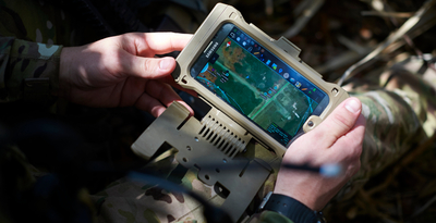
1661 followers · 238595 posts · Server schleuss.onlineThe TAK Ecosystem: Military Coordination Goes Open Source - In recent years you’ve probably seen a couple of photos of tablets and smartphones... - https://hackaday.com/2022/09/08/the-tak-ecosystem-military-coordination-goes-open-source/ #hackadaycolumns #softwarehacks #communication #androidhacks #3dmapping #military #android
#android #military #3dmapping #androidhacks #communication #softwarehacks #hackadaycolumns


