#EnthusiasticTechie 🖥 · @EnthusiasticTechie
80 followers · 5647 posts · Server mastodon.socialRT @bamwxcom: The rainfall in St Louis metro this morning qualifies as a 1000 year flood event. Some spots have seen over a foot of rainfall. St Louis officially under a flash flood emergency. And they are about to get hit with another round! Stay safe out there #stlwx #MOwx #AGwx https://t.co/Rcw8K8b1zF
Duncan da Husky · @duncandahusky
206 followers · 4331 posts · Server redwombat.socialDuncan da Husky · @duncandahusky
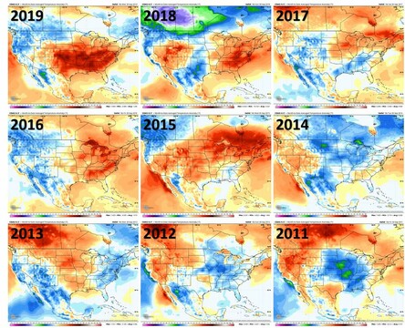
206 followers · 4331 posts · Server redwombat.socialThe next two weeks are forecasted to be cooler than normal, and that makes me so happy! I am SO DONE with summer.
RT @TDSwx@twitter.com
6 out of the last 7 Septembers have featured well above normal temps in the Midwest. The first *half* of September looks to feature widespread below normal temps, with today's European data trending even cooler. Out of the recent norm! #INwx #ILwx #OHwx #MIwx #WIwx #AGwx #Energy
#inwx #ilwx #OHwx #miwx #WIwx #AGwx #energy
Duncan da Husky · @duncandahusky
206 followers · 4331 posts · Server redwombat.socialRT @TDSwx@twitter.com
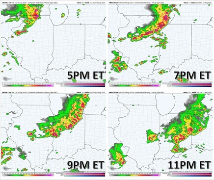
Quick four-panel of the MCS/possible #derecho progression between 5pm-11pm this evening. Strongest winds will be across N IL and NW IN, where widespread gusts of 80-100mph are likely. System will gradually weaken over IN as it moves SE. #ILwx #INwx #MIwx #WIwx #AGwx
#derecho #ilwx #inwx #miwx #WIwx #AGwx
Duncan da Husky · @duncandahusky
206 followers · 4331 posts · Server redwombat.socialHeads up Northern Illinois! Rough storms coming in this afternoon.
RT @B_Carp01@twitter.com
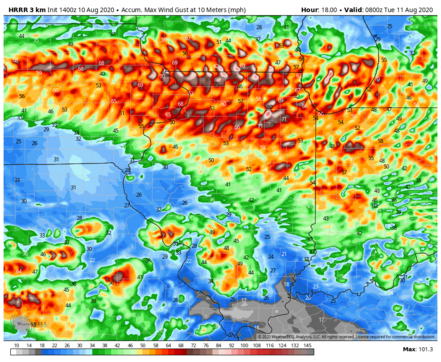
Just incredible wind gusts being depicted by the HRRR model for the incoming bowing segment of storms. This shows the swath of max gusts through this evening. Widespread damaging winds of 60-80mph possible! #IAwx #ILwx #INwx #AGwx
Duncan da Husky · @duncandahusky
206 followers · 4331 posts · Server redwombat.socialWell, dog-walking is going to be fun for the next few weeks.
RT @TDSwx@twitter.com
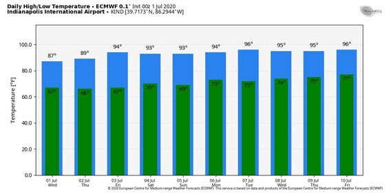
⚠️ Dangerous heat on the way for the next 7-10 days! Actual temperatures will be in the middle 90s, and indices will climb into the upper 90s to over 100 degrees at times.
#Indy #Chicago #StLouis #Cincywx #INwx #ILwx #OHwx #MIwx #WIwx #MOwx #AGwx #Energy #OATT #OOTT
#indy #chicago #stlouis #Cincywx #inwx #ilwx #OHwx #miwx #WIwx #MOwx #AGwx #energy #OATT #OOTT


