
Rainer Simon · @aboutgeo
319 followers · 83 posts · Server vis.social
#Annotorious version 3 is getting closer to release-ready. Made some major steps last weeks. It's probably time to move the work-in-progress-code into the main repo. For now, you'll find the work in progress here: https://github.com/annotorious/annotorious-v3
Rainer Simon · @aboutgeo
307 followers · 56 posts · Server vis.social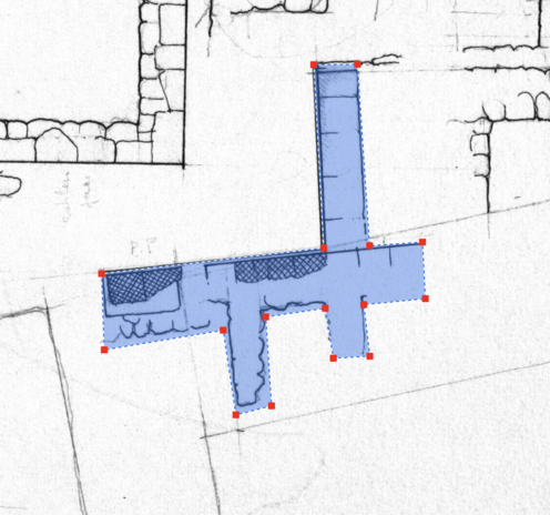
#Despair. Tried for hours (days?!) to find a good default style for #Annotorious v3 annotation shapes. Finding one that works across different backgrounds is HARD.
This ugly one is literally the best I could come up with. Blue/white dashed outline, light blue fill, bright red handle. Any design ideas & feedback much appreciated!
Rainer Simon · @aboutgeo
307 followers · 55 posts · Server vis.socialOh wow. I replaced a library I used for deep-equality checking on JS objects with a different one. (deep-equal with dequal.) And that reduced bundle size for #Annotorious v3 from ~115kB to ~60kB 😀
Rainer Simon · @aboutgeo
284 followers · 25 posts · Server vis.social@ohm @kmcdono @mradamcox we've played with it a bit, with sample 19C cadastral maps. Results were great! But it would take us more time to implement a proper processing pipeline and #Annotorious integration. Too much to code, too little time - for now ;-)
Rainer Simon · @aboutgeo
250 followers · 9 posts · Server vis.socialBack to working on an enhanced map drawing plugin for #Annotorious. Here's a new polygon tool with snap-to-corner behavior.
Rainer Simon · @aboutgeo
239 followers · 3 posts · Server vis.socialPicking up work again on realtime multiplayer image annotation for #Annotorious. Seen here: proof of concept with my notebook & phone. (Sorry for the bad video quality!) The cool part is not just the realtime sync between users. This also has a) offline support and b) realtime storage on a database server. Demo uses SQLite, but any DB would work.

Raf · @Raf
298 followers · 5913 posts · Server mastodon.socialRT @aboutgeo@twitter.com
The grouping/ordering plugin for @ReadingMaps@twitter.com is starting to work nicely. In combination with the 'tilted box' drawing tool, you can record text baseline, transcription and label sequence - all in one go. #ImageAnnotation #Maps #MachineLearning #OpenSeadragon #Annotorious
#machinelearning #ImageAnnotation #maps #OpenSeadragon #Annotorious

Amᵃᵖanda · @amapanda
684 followers · 832 posts · Server en.osm.townWell this could have been awesomely useful for when we were mapping townlands in #OpenStreetMap
RT @aboutgeo@twitter.com
More experiments with #OpenCV.js smart segmentation: extra polyline simplification produces cleaner shapes. Tracing map features with #Annotorious will never be the same 🚀
#OpenStreetMap #OpenCV #Annotorious
Raf · @Raf
298 followers · 5913 posts · Server mastodon.socialRT @aboutgeo@twitter.com
New release v2.5.8 is out for #Annotorious. The #OpenSeadragon plugin includes a first batch of performance optimizations, and now handles up to ~3.000 annotations smoothly. A big thanks to the @ReadingMaps@twitter.com project for supporting this work! https://github.com/recogito/annotorious-openseadragon/releases/tag/v2.5.8
Raf · @Raf
298 followers · 5913 posts · Server mastodon.socialRT @aboutgeo@twitter.com
I hereby declare this weekend's hack project done: another "smart selection" proof-of-concept for #Annotorious. Drag a box around a building shape, and the tool estimates the exact contours automatically. #MapAnnotation #ImageAnnotation #OpenSeadragon #IIIF
#Annotorious #MapAnnotation #ImageAnnotation #OpenSeadragon #iiif