
crowdotblack · @crowdotblack
21 followers · 152 posts · Server pdx.social
Marieke · @Marieke
306 followers · 485 posts · Server mastodon.greenZo, dagje GISsen begon met allerlei software updates.
Maar gelukt, lekker klooien met hoogtekaarten en overstomingsduurlijnen, rasters, afgravingen en ophogingen en dan een nieuwe hoogtekaart. 👍
Kan er zo in opgaan dat ik de tijd vergeet.
#LevenLangLeren #ArcGISPro #arcgis
#levenlangleren #ArcGISPro #arcgis

Nachtschatten · @nachtschatten
1 followers · 126 posts · Server ruhr.socialHello Community,
Kennt oder arbeitet jemand von euch mit einer Open Source Alternative zu ArcGIS Pro? Persönlich habe ich bereits QGIS statt ArcGIS Desktop genutzt. Gibt es ähnliches für die Pro Version?
Danke!:)
#opensource #gis #qgis #ArcGISPro #schwarmwissen #communitypower #opendata
#opensource #gis #qgis #ArcGISPro #schwarmwissen #communitypower #opendata

Raf · @Raf
298 followers · 5913 posts · Server mastodon.socialRT @geo_spatialist@twitter.com
Haven't done one of these in a while...mainly because it takes forever to render.
Saint-Léonard, Valais Canton, Switzerland - Eidg. Landestopographie - 1965
3D Render
#arcgispro #b3d #Switzerland #GIS #cARTograpy #geography
🐦🔗: https://twitter.com/geo_spatialist/status/1479812848477954055
#ArcGISPro #b3d #cARTograpy #geography #switzerland #gis

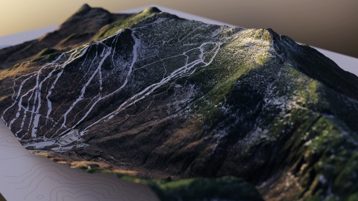
Curtis Herbert · @parrots
1160 followers · 2336 posts · Server mastodon.social
RT @geo_spatialist@twitter.com
Changed the lighting a bit and swung the camera around for a better view of the ski slopes. Not a skier myself, but a coworker who is told me I should start making ski slope maps.
#arcgispro #b3d #vermont @VCGI@twitter.com
🐦🔗: https://twitter.com/geo_spatialist/status/1334696282095570947
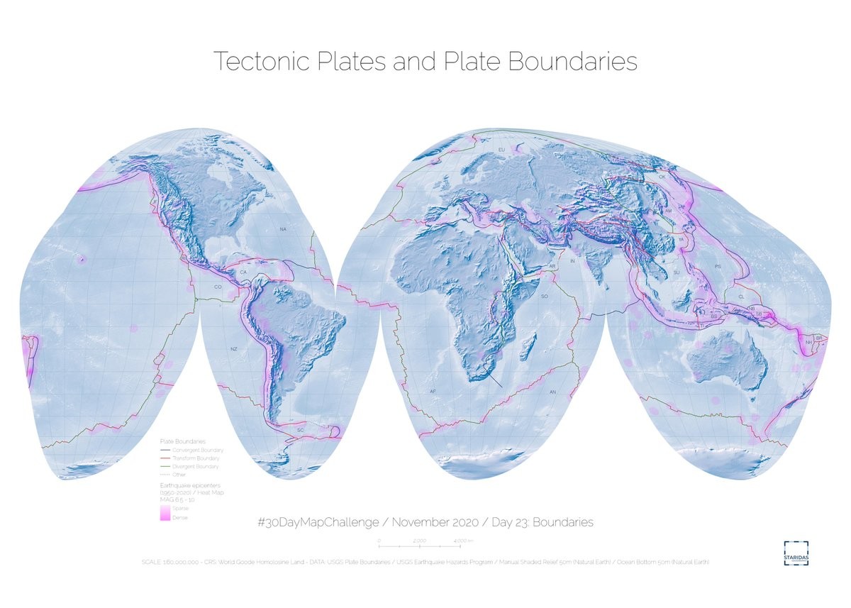
Raf · @Raf
298 followers · 5913 posts · Server mastodon.social
RT @StaridasGeo@twitter.com
Tectonic Plates and Plate Boundaries
#30daymapchallenge November 2020 Day 23: Boundaries
#cARTography #MakingMapsPretty #ArcGISPro
🐦🔗: https://twitter.com/StaridasGeo/status/1330790759080058881
#30DayMapChallenge #ArcGISPro #cartography #MakingMapsPretty
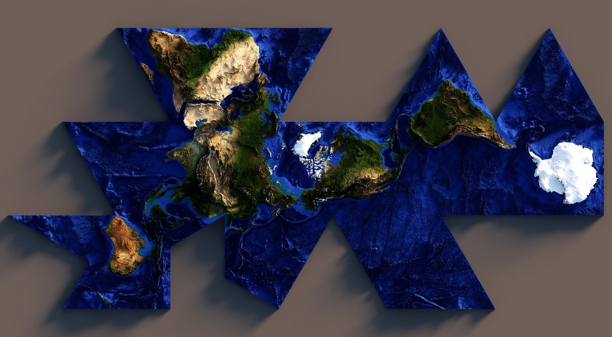
Raf · @Raf
298 followers · 5913 posts · Server mastodon.social
RT @geo_spatialist@twitter.com
Just got back from vacation and wanted to try something.
Dymaxion/Fuller Projected 3D Render of Earth with Topobathy.
#arcgispro #b3d #BuckminsterFullerReallyLovedIcosahedorns
🐦🔗: https://twitter.com/geo_spatialist/status/1313192690436186113
#ArcGISPro #b3d #BuckminsterFullerReallyLovedIcosahedorns
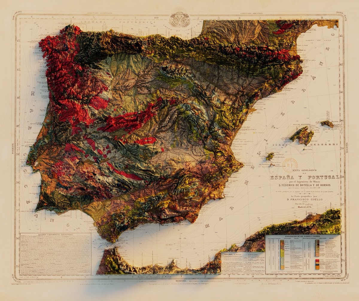
Raf · @Raf
298 followers · 5913 posts · Server mastodon.social
RT @geo_spatialist@twitter.com
Mapa Geológico de España y Portugal - por el Ingeniero de Minas D. Federico de Botella y de Hornos - la parte geográfica por D. Francisco Coello - 1879
#arcgispro #blender #gis #maps #dataviz #datavisualization #copernicus #srtm
🐦🔗: https://twitter.com/geo_spatialist/status/1262064577807822848
#ArcGISPro #blender #gis #maps #dataviz #datavisualization #copernicus #srtm
Raf · @Raf
298 followers · 5913 posts · Server mastodon.socialRT @geo_spatialist@twitter.com
"Visualize, Analyze, Materialize" or "1878 meets 2020"
Preliminary geological map of the Yellowstone National Park - 1878 - Library of Congress: https://www.loc.gov/item/97683605/
#arcgispro #arcgis #blender #yellowstone #usgs
🐦🔗: https://twitter.com/geo_spatialist/status/1220372000901943297
#ArcGISPro #arcgis #blender #yellowstone #usgs
OnlMaps · @onlmaps
1360 followers · 4705 posts · Server mastodon.socialRT @Cchurchili@twitter.com
Getting back into #ArcGISPro maps with this little map about the high winds on the Great Plains
This map is dedicated to my hometown, and the wind that keeps me up at 2 am. Frequently.
🐦🔗: https://twitter.com/Cchurchili/status/1204229521102143488