Mark Ingalls :pdx_badge: · @ingalls
1398 followers · 4857 posts · Server pdx.social#CanadaDay forecast for the #LowerMainland and southern #VancouverIsland:
A few clouds otherwise mostly sunny. Highs ranging from 20°C near the water to 23°C inland (places like Abbotsford). Dropping by a few degrees for fireworks.
A stiff breeze along the water, out of the northwest along the Strait of Georgia, out of the west along the Strait of Juan de Fuca. #Fire danger is low to moderate, but don’t be dumb.
#canadaday #lowermainland #VancouverIsland #fire #vancouver #yvr #victoria #BCStorm #weather #wxtooter
Mark Ingalls :pdx_badge: · @ingalls
1353 followers · 4580 posts · Server pdx.social
Mark Ingalls :pdx_badge: · @ingalls
1327 followers · 4361 posts · Server pdx.social
Mark Ingalls :pdx_badge: · @ingalls
1320 followers · 4264 posts · Server pdx.social
Mark Ingalls :pdx_badge: · @ingalls
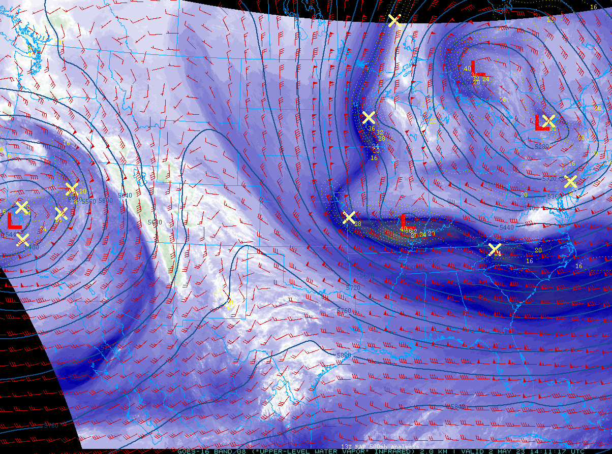
1318 followers · 4229 posts · Server pdx.socialA strong upper level low may swing south into the Pacific Northwest to bring below average temperatures and wetter (but not super wet) conditions. Models favoring highs near 20°C Sunday and Monday in #Portland.
Right now, this upper level system is located in Siberia. Models have it going from there to the Aleutian Islands and then down to the Northwest over the next week.
#portland #pdxtst #orwx #wawx #BCStorm #weather #wxtooter
Mark Ingalls :pdx_badge: · @ingalls
1308 followers · 4157 posts · Server pdx.social
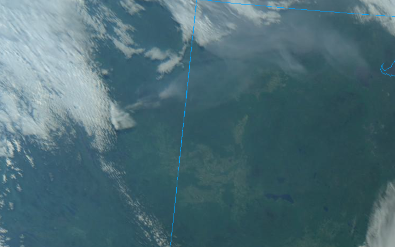
Satellite view of smoke from the #DonnieCreekFire north of Fort St. John in #BritishColumbia drifting east across the northern quarter of #Alberta Tuesday morning.
#donniecreekfire #britishcolumbia #alberta #BCStorm #abstorm #weather #fire
Mark Ingalls :pdx_badge: · @ingalls
1308 followers · 4155 posts · Server pdx.socialWildfire north of Fort St. John now one of the largest in #BritishColumbia history - 2400 sq km.
#britishcolumbia #BCStorm #fire #weather
Mark Ingalls :pdx_badge: · @ingalls
1299 followers · 4125 posts · Server pdx.socialPacific Northwest snowpack:
Snow-water equivalent in the Columbia River watershed continues to drop rapidly and is currently at 28% of average. The Snake River portion is the best at 50% of average.
West side drainages are running about 40% of average, BC Salish Sea drainages around 14%, and the Peace River watershed is 25%.
Columbia watershed is on track to be pretty much done for the season in the next two weeks or so.
#weather #water #wawx #orwx #idwx #BCStorm #pdxtst
Mark Ingalls :pdx_badge: · @ingalls
1293 followers · 4061 posts · Server pdx.social
Mark Ingalls :pdx_badge: · @ingalls
1282 followers · 3902 posts · Server pdx.social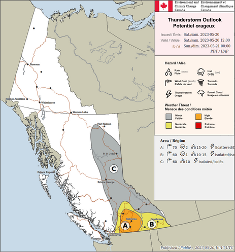
High threat of strong to severe thunderstorms in the #BritishColumbia Okanagan region, including #Kelowna and #Kamloops, Saturday afternoon and evening.
Wind gusts to 70 km/h, hail to 2 cm in diameter, and flash flooding are possible.
A broader area with less severe but still quite wet storms extends from near Hope to the Alberta border and a little ways north of Kamloops with isolated storms possible clear to almost Fort Nelson.
#britishcolumbia #kelowna #kamloops #BCStorm #weather
Mark Ingalls :pdx_badge: · @ingalls
1242 followers · 3637 posts · Server pdx.social
Mark Ingalls :pdx_badge: · @ingalls
1232 followers · 3539 posts · Server pdx.socialSnowpack in the Columbia watershed peaked above average over the last few weeks. This week it has dropped rapidly due to warm temperatures throughout the Pacific Northwest, but is still looking healthy.
Periods of rapid declines are common during the melt season. The melting should slow over the coming days.
#orwx #wawx #BCStorm #pdxtst #water
Mark Ingalls :pdx_badge: · @ingalls
1227 followers · 3523 posts · Server pdx.social
Mark Ingalls :pdx_badge: · @ingalls
1225 followers · 3498 posts · Server pdx.socialEvacuation notice issued due to a #wildfire southeast of Alexis Creek, British Columbia which is a ways west of Williams Lake.
#bcstorm #weather #fire #bcfire
https://www.cariboord.ca/2023-04-29%20Dripping%20Water%20Area%20Alert%20-%20signed.pdf
#wildfire #BCStorm #weather #fire #bcfire
Mark Ingalls :pdx_badge: · @ingalls
1220 followers · 3460 posts · Server pdx.socialMy belated #FollowFriday offering this week is @edwardsanthonyb.
Anthony is a contributing meteorologist at the @sfchronicle who graduated from the University of Washington. Great #weather content from him for all of Western North America! He’s new here so give him a warm welcome!
Honorary mention to @geravitywave who is also a meteorologist at the San Francisco Chronicle who also has great weather content and is fun to chat with.
#followfriday #weather #wawx #orwx #cawx #BCStorm
Mark Ingalls :pdx_badge: · @ingalls
1205 followers · 3363 posts · Server pdx.social
Mark Ingalls :pdx_badge: · @ingalls
1190 followers · 3272 posts · Server pdx.socialPacific Northwest snowpack report today:
We’re about a week past the seasonal peak, both average and for this year.
• Columbia watershed: 103% of average
• BC Columbia: 94%
• US Columbia: 95%
• Snake: 114%
• WA/OR west of the Caecades: 106%
• Peace (NE BC): 87%
Overall looking pretty healthy. Especially strong in the Great Basin and the upper Snake watershed.
#weather #orwx #wawx #idwx #BCStorm
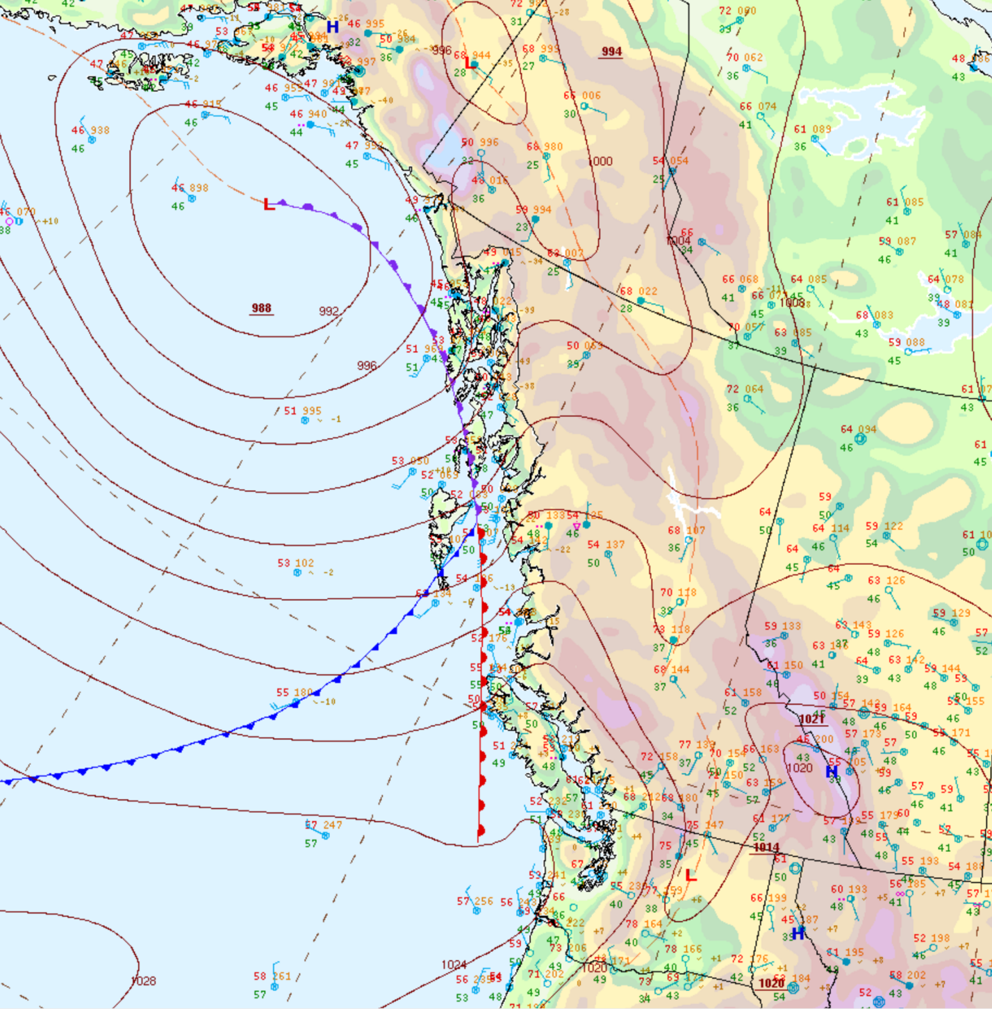
Mark Ingalls :pdx_badge: · @ingalls
1156 followers · 2950 posts · Server pdx.socialIt looks like the next decent low heading for the Pacific Northwest comes Friday into Saturday. Models have it following a classic fall wind storm track with it making landfall near the Olympic Peninsula as it tracks northeastward. Periods of heavy rain, mountain snow, and breezy conditions possible.
Mark Ingalls :pdx_badge: · @ingalls
1154 followers · 2925 posts · Server pdx.social