
65dBnoise · @65dBnoise
1297 followers · 198 posts · Server mastodon.socialHere is a naive radio coverage map using "depth below horizon" adjusted to make landing location 45 at 12m altitude "visible" to the rover, on Sol 714. The same value for "depth below horizon" appears to be working for most of the other suspected NLOS links between #Ingenuity and #perseverance, and definitely for that of #Flight17.
The animation shows coverage from 12m altitude and from the ground, i.e. 0.48m.
#ingenuity #perseverance #Flight17 #qgis #hirise #marshelicopter #mars2020 #solarocks #space
65dBnoise · @65dBnoise
1295 followers · 123 posts · Server mastodon.social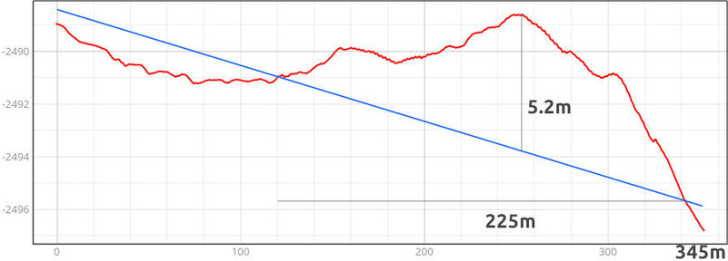
#Ingenuity's #Flight43 was announced on 2023-02-10, or Sol 703 of the #Mars2020 mission, when #Perseverance was about 345m from the #MarsHelicopter. The ground profile (image 1) shows a ground obstruction depth of max 5m for about 225m of the total distance separating the two crafts. The only publicly known communications failure occurred after #Flight17 (image 2)[1]. It shows that there was no workable radio link
1/
[1] https://mars.nasa.gov/technology/helicopter/status/350/flight-17-discovering-limits
#ingenuity #flight43 #mars2020 #perseverance #marshelicopter #Flight17 #nasa #solarocks #space