
Josh Carlson :qgis: · @jcarlson
510 followers · 927 posts · Server mapstodon.space
Josh Carlson :qgis: · @jcarlson
510 followers · 926 posts · Server mapstodon.spaceHey, #gischat !
I am thinking about making some custom web maps for my org using #MapLibre or something, but I have a question.
Is anyone using a static site generator for a #gis site? I have some SSGs that I like, but they seem to be better suited for longer, scrolling stuff, not full-screen maps.

Lost Mapper · @lostmapper
8 followers · 14 posts · Server mapstodon.space
My first video is up - Getting Started with QGIS: https://youtu.be/mM9AJxKkpH0 #gis #qgis #cartography #maps

Matt Malone · @MattMalone
203 followers · 157 posts · Server mapstodon.space
Matt Malone · @MattMalone
204 followers · 155 posts · Server mapstodon.space
Cleaning my desk today and discovered that I still had a parallel port key. #GIS #ItBelongsInAMuseum

Dragons8mycat · @Dragons8mycat
543 followers · 833 posts · Server mapstodon.spaceIt's follow Friday #ff, been a few years since I did one of these!
#geospatial and #gis
@ThomasG77
@geoemka
@LowOrbitTourist
@alan_geog
@rastrau
@anlugonz
@underdarkGIS
@fg
@Cartonaut
@klaskarlsson
@geoObserver
@geospacedman
@MiniMapMakers
@HarelDan
@GeoDon
@RebelGeo
@lutraconsulting
@liam_na_mara
@tom
@qgis
@schrockg
@wilsongis

Andrew Middleton · @ecoandrewtrc
142 followers · 128 posts · Server mapstodon.spaceIt's official. In another month I'll be the owner of The Map Center in Providence, Rhode Island. It's taken me a long time to get to this point where moving across the country to take up a small business seemed like a good idea but I'm ready for this adventure. It's a #GIS map nerd's dream.
Follow me to keep up with this story as it unfolds. It's gonna be wild.
Matt Malone · @MattMalone
203 followers · 150 posts · Server mapstodon.space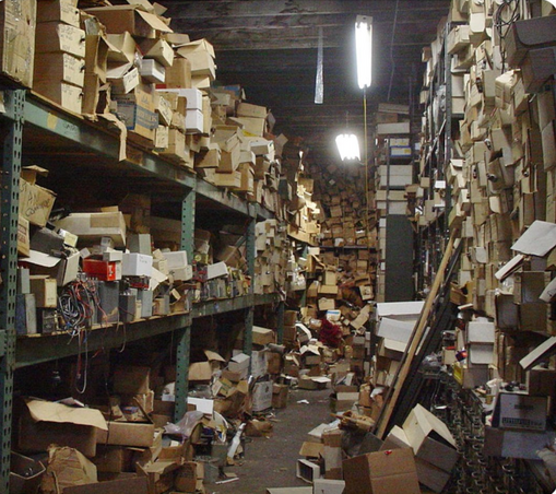
Dragons8mycat · @Dragons8mycat
539 followers · 832 posts · Server mapstodon.spaceI'm looking for an imagery basemap for the whole of the UK which is updated at a minimum of annually for everywhere in the UK.....
....anyone out there know of one?
...even a 2m super resolution Sentinel 2 would be fine ;)
Dragons8mycat · @Dragons8mycat
538 followers · 831 posts · Server mapstodon.spaceA new VerySpatial podcast is out! A VerySpatial Podcast – Episode 721, listen to it here: https://veryspatial.com/2023/09/a-veryspatial-podcast-episode-721/
#GIS #GISChat
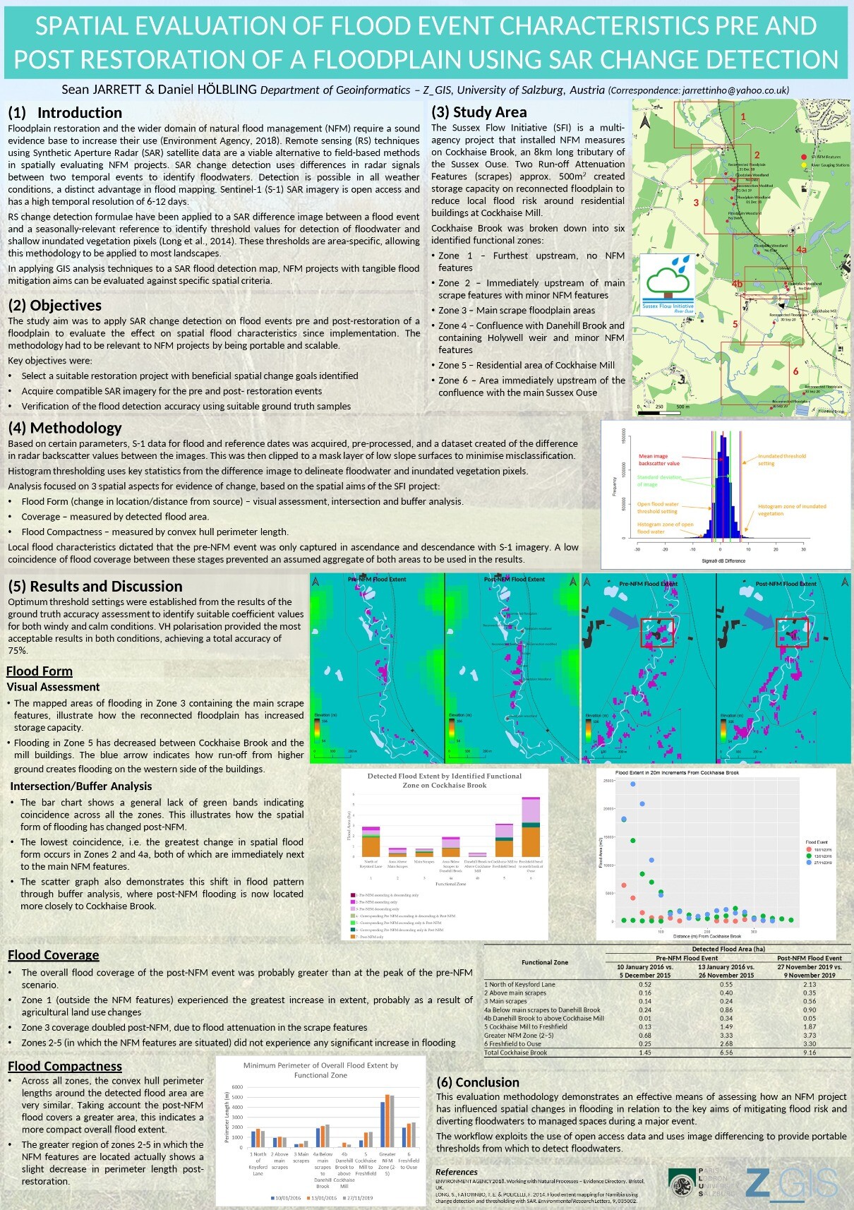
Sean Jarrett · @jarrettinho
8 followers · 25 posts · Server mapstodon.space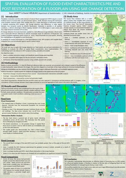
On my way to present our research poster on #naturalfloodmanagement #remotesensing #sar #gis #qgis #changedetection at the #theRRC #SARR23 #riverrestoration conference at at Liverpool University
#qgis #changedetection #therrc #sarr23 #riverrestoration #naturalfloodmanagement #remotesensing #sar #GIS
Matt Malone · @MattMalone
202 followers · 148 posts · Server mapstodon.space
Andrew Middleton · @ecoandrewtrc
140 followers · 123 posts · Server mapstodon.spaceAny #GIS folks have a good tool for extracting profiles from DEMs using a wider selection tool that a single skinny transect line?
Lost Mapper · @lostmapper
3 followers · 5 posts · Server mapstodon.space
Postholer · @postholer
114 followers · 70 posts · Server mapstodon.space
Matt Malone · @MattMalone
202 followers · 148 posts · Server mapstodon.space
Dragons8mycat · @Dragons8mycat
535 followers · 823 posts · Server mapstodon.spaceIf you want to add around 30 basemaps to your #QGIS (including OSM and Stamen) you can open your python console (in QGIS) and paste this code:
https://raw.githubusercontent.com/dragons8mycat/QGIS-xyz-tileservers/main/add_layers_to_qgis.py
#gis #geo #gischat
many thanks to Klas Karlsson for the base script

WorldPopProject · @WorldPopProject
247 followers · 128 posts · Server mapstodon.space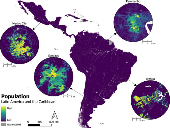
🚨 WorldPop analysis published together with #UNFPA #LACRO Università degli Studi di Milano #unimib and the German Aerospace Center #DLR on the production of high-resolution gridded population datasets for 40 Latin America/Caribbean countries using official statistics: https://lnkd.in/en5FmkxQ
#unfpa #lacro #unimib #dlr #census #GIS #demography #remotesensing #stats #statistics
Matt Malone · @MattMalone
202 followers · 148 posts · Server mapstodon.space
Dragons8mycat · @Dragons8mycat
535 followers · 822 posts · Server mapstodon.spaceGiong beyond the #map....@Google looks to provide #environment APIs
https://cloud.google.com/blog/products/maps-platform/going-beyond-map-introducing-environment-apis?
#gis #geospatial
#map #environment #GIS #geospatial