
MAHSA Project · @mahsa_project
0 followers · 2 posts · Server archaeo.social
A major aspect of our work has been our collaboration with #libraries such as the @britishlibrary and University of Cambridge #Library.
We have digitised 100s of #historicmaps of the #Indus Basin region in the hope that we will make them available online for the public. Not only will they be scanned but they will also be #georeferenced for spatial analysis.
#archives #map #heritage #remotesensing #archaeology
@RebeccaRoberts
#libraries #library #HistoricMaps #indus #georeferenced #archives #map #heritage #remotesensing #archaeology

Nika Shilobod · @NikaShilobod
1992 followers · 2183 posts · Server fediscience.org
Last but not least is #Linconshire's "The Map of #SouthHolland"
"Holland is all close to #sealevel, achieving a maximum altitude of about five metres (16 feet) on artificially raised river banks (levees). It therefore needed carefully managed #drainage to maintain the very [...]"
@geography @histodons #HistoricMaps #Geography #histodons
/32
#histodons #geography #HistoricMaps #drainage #sealevel #southholland #linconshire
Nika Shilobod · @NikaShilobod
1988 followers · 2180 posts · Server fediscience.org
Next Up, no. 10 is this famous #Somerset #SomersetLevels #wetland: "The Map of #Sedgemoor, with adjacent Parts"
@histodons @geography #HistoricMaps #histodons
"The area through which the [King's Sedgemoor] drain runs was farmed as common land when it was owned by the Abbey at Glastonbury, but with its dissolution in 1539, [...]" /29
#histodons #HistoricMaps #sedgemoor #wetland #somersetlevels #somerset
Nika Shilobod · @NikaShilobod
1986 followers · 2177 posts · Server fediscience.org
No 9 finds us at #RomneyMarsh: "The Description of Romney Marsh, Walland Marsh, Denge Marsh, and Guildford Marsh, with the Divisions of their Waterings, their Heads, principal Sewers, and their Guts, for the sewing of the Fresh Waters that fall into the same: [...]" #Kent #EastSussex #HistoricMaps @histodons @geography
#HistoricMaps #eastsussex #kent #romneymarsh
Nika Shilobod · @NikaShilobod
1986 followers · 2175 posts · Server fediscience.org
No. 8 is: "The Map of the #marshland in #Norfolk, which contain only these Seven Towns, viz. #Emneth, #Walsoken, #Walton, #Walpole, #Tirington, #Tilney and #Clenchwarton; St. John's being Part of the Parish of Tirington; St. Laurence and #Ilsington Parts of Tilney; #OldLynne, containing #WestLynne and #NorthLynne, which is also within the [...]"
#Wash #TheWash #Drainage #Peat @histodons @geography #HistoricMaps
#HistoricMaps #peat #drainage #thewash #wash #northlynne #westlynne #oldlynne #ilsington #clenchwarton #tilney #tirington #walpole #walton #walsoken #emneth #norfolk #marshland
Nika Shilobod · @NikaShilobod
1985 followers · 2168 posts · Server fediscience.org
No. 7 is "The Map of #Lindsey Level" in #Lincolnshire
It seems this was a very early #drainage work, as it no longer exists (Please correct me if I am wrong.).
According to wiki: "Compared to its neighbour, the #Welland, there are few records of the history of the Glen. Dugdale, writing his book [...]" /20
#HistoricMaps #welland #drainage #lincolnshire #lindsey
Nika Shilobod · @NikaShilobod
1960 followers · 2142 posts · Server fediscience.org
These two are probably the coolest of the bunch, and go together. These depict the before and after #draingage of he #Fens or #Fenlands in #Linclonshire, #Cambridgeshire, #Suffolk, and #Norfolk. These #maps show how extensive these works were. You can imagine the ecological consequences that are still impacting us today. /11
#wetlands #geography #histodons #HistoricMaps #maps #norfolk #suffolk #cambridgeshire #linclonshire #fenlands #fens #draingage
Nika Shilobod · @NikaShilobod
1958 followers · 2138 posts · Server fediscience.org
Nika Shilobod · @NikaShilobod
1957 followers · 2132 posts · Server fediscience.org
First up, is the River #Ancholme.
"The draining of the Ancholme Level was a lesser project among the fenland 'improvements' undertaken under contracts to patentees by the government of Charles I in the 1630s. It was somewhat less brutal than many such projects, for [...]"
#histodons #gis #HistoricMaps #ancholme

Henrik Schönemann · @lavaeolus
658 followers · 1428 posts · Server mastodon.lol@NikaShilobod
👋 - definitely interested!
Both in using and collaborating/contributing :)
Do you mean #HistoricMaps as in 'historical maps', e.g. maps from 1500?
Or as in 'maps of historical information', e.g. a map showing the regions of central europe in 1500?
(I'm interested either way)
Nika Shilobod · @NikaShilobod
1951 followers · 2106 posts · Server fediscience.orgI am thinking about making an #Awesome list for #HistoricMaps . Is there any interest in this/would others like to collaborate or contribute? @histodons
@geography #Histodons #History #GIS #Geography
#geography #gis #history #histodons #HistoricMaps #awesome
Nika Shilobod · @NikaShilobod
1540 followers · 1596 posts · Server fediscience.orgHey folks! What are your favorite tools to vectorize #HistoricMaps for #GIS? #QGIS #Mapstodon #Maps
#maps #mapstodon #qgis #gis #HistoricMaps

Ancestral Enquiries · @AncestralEnquiries
108 followers · 238 posts · Server toot.community
RT @wyorksarchives@twitter.com
We can (just!) fit a whole primary school class around our fabulous reproduction walk-on map of Wakefield in 1823. It’s great to be able to see what’s changed over the last 200 years and what hasn’t #ExploreYourArchive #HistoricMaps #WakefieldSchools #EYAMapsPlans
🐦🔗: https://twitter.com/wyorksarchives/status/1597168879582732288
#ExploreYourArchive #HistoricMaps #wakefieldschools #eyamapsplans

Northumbrian Stories · @northfolk
322 followers · 164 posts · Server mstdn.social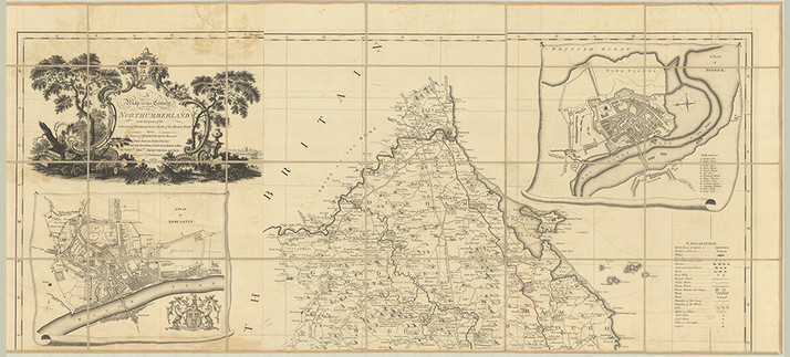
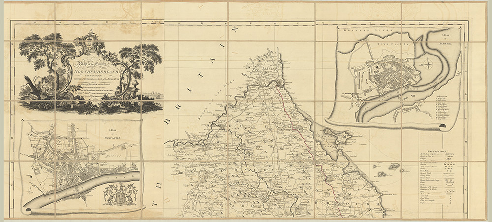
One of my favourite historic maps is the 1769 map of Northumberland by Andrew Armstrong. Not as detailed as later maps, but so fascinating to explore and compare. Pic is Sheet 1 (compressed), but the whole thing can be accessed with HD zoom and download options at http://digitalarchive.mcmaster.ca/islandora/object/macrepo%3A92703
#HistoricMaps #OldMaps #Northumberland #NorthumbrianHistory #18thCentury #Histodons #History #LocalHistory
#LocalHistory #History #histodons #18thcentury #northumbrianhistory #northumberland #oldmaps #HistoricMaps

Shane Wilson · @shanew147
130 followers · 86 posts · Server mastodon.ie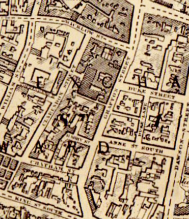
Hi-res browsable#map of #Dublin city and Environs dated 1880, from Thom's #Directory - also some notes on the process used to scan
#dublin #directory #Dublinhistory #HistoricMaps

Markus · @mbirth
78 followers · 1226 posts · Server mastodon.social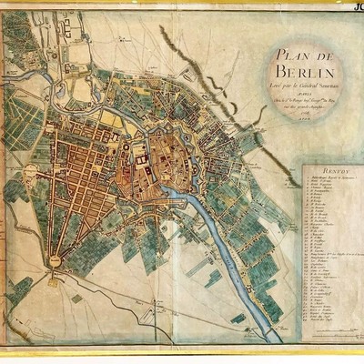
Berlin 1758
#berlin #historicmaps #map #maps #oldmaps #oldmap #1758 #berlin1758 https://instagr.am/p/CTuZ1Rnqzc0/
#berlin #HistoricMaps #map #maps #oldmaps #oldmap #berlin1758