
Arga · @Argacyan
1 followers · 20 posts · Server mapstodon.space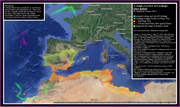
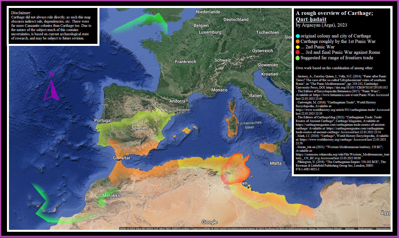
Backup Nr.9 of "Map depicting the original colony & city of #carthage as well as the #CarthaginianEmpire at 3 more points in time, and also a suggested far range of frontiers #trade between it & other areas from #NorthAfrica to #britain "
As always further information is embedded on the image itself.
#maps #map #HistoricalMaps #history #antiquity #classicalantiquity #PunicWars #punic #phoenicians #europe #africa #semitic #histodons #histodon
#carthage #carthaginianempire #trade #northafrica #britain #maps #map #HistoricalMaps #History #antiquity #classicalantiquity #punicwars #punic #phoenicians #Europe #Africa #semitic #histodons #histodon
Arga · @Argacyan
1 followers · 19 posts · Server mapstodon.space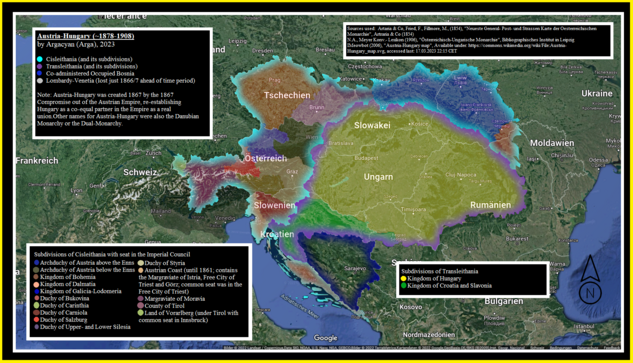
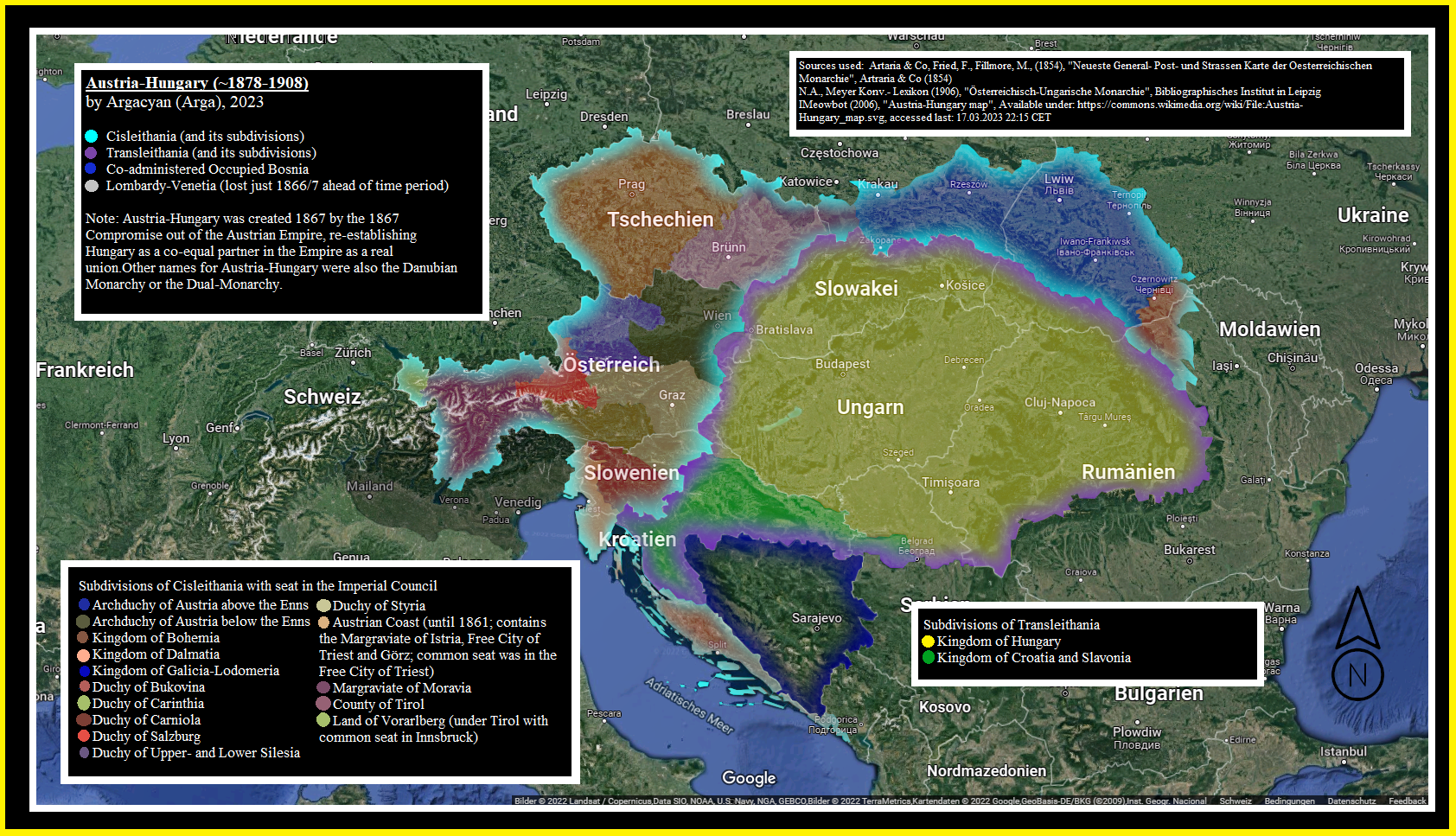
Backup Nr.8 of "Map of #AustriaHungary in the late #19thcentury , showing the major divisions #cisleithania and #transleithania as well as their subdivisions, also showing co-administered #bosnia and indicating the then-recently lost #LombardyVenice "
#maps #map #HistoricalMaps #history #europe #austria #hungary #ukraine #czechia #slovakia #slovenia #italy #romania #croatia #balkan #danube #victorian #tirol #Moldovia #moldova #moldawien #osterreich #ungarn #magyarorszag #histodon #histodons
#austriahungary #19thcentury #cisleithania #transleithania #bosnia #lombardyvenice #maps #map #HistoricalMaps #History #Europe #austria #hungary #Ukraine #czechia #SLOVAKIA #slovenia #italy #Romania #croatia #balkan #danube #victorian #tirol #moldovia #moldova #moldawien #osterreich #ungarn #magyarorszag #histodon #histodons
Arga · @Argacyan
1 followers · 17 posts · Server mapstodon.space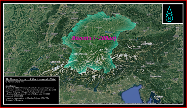
Backup Nr.6 of "The Roman province of Rhaetia around 200ad, according to Gustav Droysen (1886) based on Claudius Ptolemy"
#map #maps #romanempire #rome #germania #germany #austria #switzerland #GreyLeagues #RhaetoRoman #alps #classicalantiquity #antiquity #historicalmaps #histodon #history #histodons
#map #maps #romanempire #rome #germania #germany #austria #switzerland #greyleagues #rhaetoroman #alps #classicalantiquity #antiquity #HistoricalMaps #histodon #History #histodons
Arga · @Argacyan
1 followers · 16 posts · Server mapstodon.space
Backup Nr.5: "Map depicting the outermost reach of the #SwissConfederation ..."
[Description cut due to character limits...]
#maps #map #europe #history #HistoricalMaps #ThreeLeagues #Italy #germany #france #alps #aosta #geneva #BadenWurttemberg #alsace #elsass #rottweil #lombardy #holyromanempire #hre #medieval #renaissance #histodon #histodons
#swissconfederation #maps #map #Europe #History #HistoricalMaps #threeleagues #italy #germany #France #alps #aosta #geneva #BadenWurttemberg #alsace #elsass #rottweil #lombardy #holyromanempire #hre #medieval #renaissance #histodon #histodons
Arga · @Argacyan
1 followers · 12 posts · Server mapstodon.space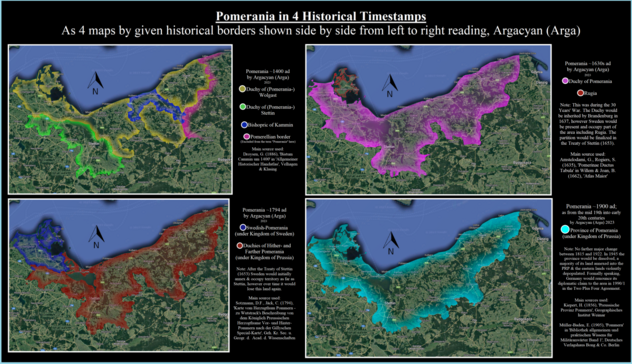
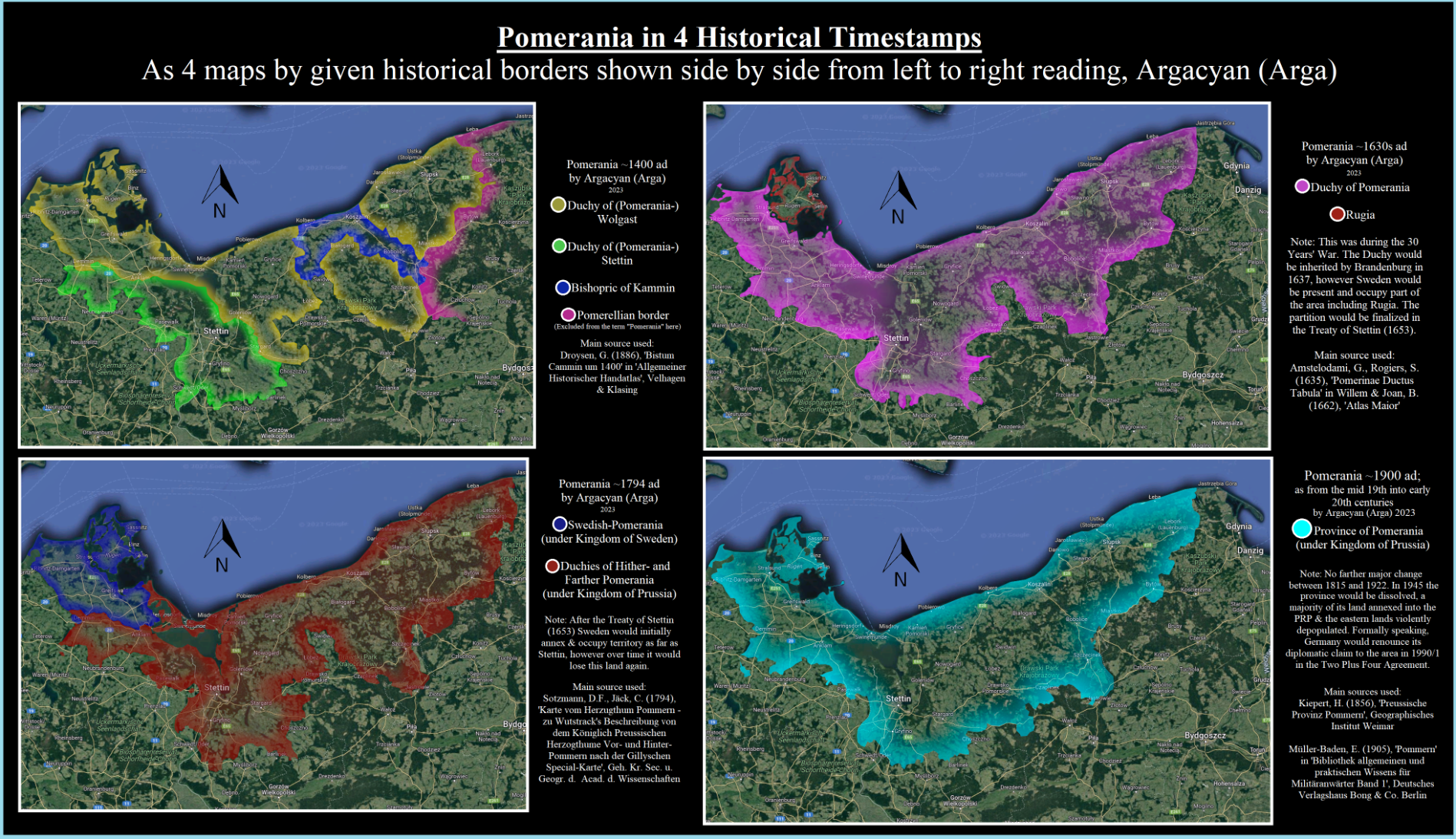
Backup Nr.1 of "Pomerania at 4 points in time"
All necessary information & citations are embedded on the images themselves.
[deleted description due to character limits]
One image shows those 4 timestamps separately, the other image shows you a superposition of those borders for comparison.
#maps #map #HistoricalMaps #pomerania #germany #german #poland #sweden #europe #history #prussia #brandenburg #mecklenburg #histodons #histodon
#maps #map #HistoricalMaps #pomerania #germany #german #Poland #sweden #Europe #History #prussia #brandenburg #mecklenburg #histodons #histodon
Arga · @Argacyan
1 followers · 11 posts · Server mapstodon.spaceThis post will be pinned here as a backup of the map-thread from my main instance due to reports of visibility & access problems.
It will be kept updated same as the original thread.
(Link to original: "https://yiff.life/@Argacyan/110154152709624000")
#art #maps #map #mapping #mapmaking #HistoricalMaps #GeographicalMaps #LinguisticMaps #mapstodon #histodon #histodons #HistoricalMaps
#Art #maps #map #mapping #mapmaking #HistoricalMaps #geographicalmaps #linguisticmaps #mapstodon #histodon #histodons

Julien Benedetti · @macgraveur
438 followers · 1517 posts · Server framapiaf.org@DamienPetermann @sophieboudarel ça va finir en #HistoricalMaps :) bien volontiers pour les retours. Surtout que les rendus géographiques sont des grosses attentes du public plus généraliste.

Arga · @Argacyan
25 followers · 367 posts · Server yiff.life
2 last maps encompassing the superposition here separately shown for detail. These are the year 1812 and mid-19th century.
#maps #map #historicalmaps #prussia #germany #poland #brandenburg #history #europe #europa #pomerania #histodon #histodons #Preußen #Preussen #TeutonicOrder #Teutonic #GermanOrder
#maps #map #HistoricalMaps #prussia #germany #poland #brandenburg #history #europe #europa #pomerania #histodon #histodons #preußen #preussen #teutonicorder #teutonic #germanorder
Arga · @Argacyan
25 followers · 365 posts · Server yiff.life
4 of the maps encompassing the superposition here separately shown for detail. 13th, 14th, 15th-17th and mid-18th centuries.
#maps #map #historicalmaps #prussia #germany #poland #brandenburg #history #europe #europa #pomerania #histodon #histodons #Preußen #Preussen #TeutonicOrder #Teutonic #GermanOrder
#maps #map #HistoricalMaps #prussia #germany #poland #brandenburg #history #europe #europa #pomerania #histodon #histodons #preußen #preussen #teutonicorder #teutonic #germanorder
Arga · @Argacyan
25 followers · 364 posts · Server yiff.life
Prussia at 6 points in time. All necessary information and citations embedded on the images again.
Prussia is a region in eastern Europe /the baltics, also used to be a country. It went from a monastic order, to a divided secular state, to personal union, to empire until the end of WW1 before ending completely with the end of WW2. For more information if needed check the individual maps or ask me directly, cause that might take more than the character limit to give explanations.
Image 1 shows those 6 timestamps as a superposition for comparison with them imposed ontop of each other. Image 2 shows those 6 timestamps separately.
#maps #map #historicalmaps #prussia #germany #poland #brandenburg #history #europe #europa #pomerania #histodon #histodons #Preußen #Preussen #TeutonicOrder #Teutonic #GermanOrder
#maps #map #HistoricalMaps #prussia #germany #poland #brandenburg #history #europe #europa #pomerania #histodon #histodons #preußen #preussen #teutonicorder #teutonic #germanorder
Arga · @Argacyan
19 followers · 203 posts · Server yiff.life
(edit: repost since I noticed the original post wasn't updating properly...)
Map showing select #Phoenician / #Canaanite colonies and settlements with their known or reasonably suggested endonymic names.
This map is more information card than eye-candy, with a look-up table of settlements, being a review of almost 90 different sources. As always all information is on the image. There are two versions here: A and B, with B being for if A is too hard to read.
I did try to automate citations due to the ridiculous amount of reading. There may be errors due to the software.
#map #maps #classicalantiquity #phoenicians #mediterranean #europe #northafrica #africa #levante #cyprus #spain #portugal #morocco #algeria #tunisia #lybia #italy #punic #semitic #antiquity #historicalmaps #history #carthage
#phoenician #canaanite #map #maps #classicalantiquity #phoenicians #mediterranean #europe #northafrica #africa #Levante #cyprus #spain #portugal #morocco #algeria #tunisia #lybia #italy #punic #semitic #antiquity #HistoricalMaps #history #carthage
Arga · @Argacyan
9 followers · 75 posts · Server yiff.life
Update for an older map: The Roman province of Rhaetia around 200ad, according to Gustav Droysen (1886) based on Claudius Ptolemy.
#map #maps #romanempire #rome #germania #germany #austria #switzerland #GreyLeagues #RhaetoRoman #alps #classicalantiquity #antiquity #historicalmaps #history
#map #maps #romanempire #rome #germania #germany #austria #switzerland #greyleagues #rhaetoroman #alps #classicalantiquity #antiquity #HistoricalMaps #history
Arga · @Argacyan
9 followers · 52 posts · Server yiff.life
Map showing select #Phoenician / #Canaanite colonies and settlements with their known or reasonably suggested endonymic names.
This map is more information card than eye-candy, with a look-up table of settlements, being a review of almost 90 different sources. As always all information is on the image. There are two versions here: A and B, with B being for if A is too hard to read.
#map #maps #classicalantiquity #phoenicians #mediterranean #europe #northafrica #africa #levante #cyprus #spain #portugal #morocco #algeria #tunisia #lybia #italy #punic #semitic #antiquity #historicalmaps #history #carthage
#phoenician #canaanite #map #maps #classicalantiquity #phoenicians #mediterranean #europe #northafrica #africa #Levante #cyprus #spain #portugal #morocco #algeria #tunisia #lybia #italy #punic #semitic #antiquity #HistoricalMaps #history #carthage
Arga · @Argacyan
9 followers · 48 posts · Server yiff.life
Map depicting the original colony & city of #carthage as well as the #CarthaginianEmpire at 3 more points in time, and also a suggested far range of frontiers #trade between it & other areas from #NorthAfrica to #britain .
As always further information is embedded on the image itself.
#maps #map #HistoricalMaps #history #antiquity #classicalantiquity #PunicWars #punic #phoenicians #europe #africa #semitic
#carthage #carthaginianempire #trade #northafrica #britain #maps #map #HistoricalMaps #history #antiquity #classicalantiquity #punicwars #punic #phoenicians #europe #africa #semitic
Arga · @Argacyan
9 followers · 46 posts · Server yiff.life
Map depicting the outermost reach of the #SwissConfederation , as in showing modern borders vs areas outside of that which in the past belonged either directly to any current member state of Switzerland, or past associate states, or areas which were part of past associate states. The valley of #Veltlin shown in particular, as it was a major part of the #GreyLeagues , which themselves used to be merely an associate of #Switzerland rather than a member state.
#maps #map #europe #history #HistoricalMaps #ThreeLeagues #Italy #germany #france #alps #aosta #geneva #BadenWurttemberg #alsace #elsass #rottweil #lombardy #holyromanempire #hre #medieval #renaissance
#swissconfederation #veltlin #greyleagues #switzerland #maps #map #europe #history #HistoricalMaps #threeleagues #italy #germany #france #alps #aosta #geneva #BadenWurttemberg #alsace #elsass #rottweil #lombardy #holyromanempire #hre #medieval #renaissance
Arga · @Argacyan
8 followers · 41 posts · Server yiff.life
Map of #AustriaHungary in the late #19thcentury , showing the major divisions #cisleithania and #transleithania as well as their subdivisions, also showing co-administered #bosnia and indicating the then-recently lost #LombardyVenice
Information is again embedded on the image itself.
#maps #map #HistoricalMaps #history #europe #austria #hungary #ukraine #czechia #slovakia #slovenia #italy #romania #croatia #balkan #danube #victorian #tirol #Moldovia #moldova #moldawien #osterreich #ungarn #magyarorszag
#austriahungary #19thcentury #cisleithania #transleithania #bosnia #lombardyvenice #maps #map #HistoricalMaps #history #europe #austria #hungary #ukraine #czechia #slovakia #slovenia #italy #romania #croatia #balkan #danube #victorian #tirol #Moldovia #moldova #moldawien #osterreich #ungarn #magyarorszag
Arga · @Argacyan
6 followers · 22 posts · Server yiff.life
Here are the same 4 maps of Pomerania as in the above post, as individual image files. Same as before all of the information & citations are on the images themselves.
#pomerania #HistoricalMaps #maps #map #germany #german #poland #sweden #europe #medieval #renaissance #prussia #brandenburg #mecklenburg #stettin #wolgast #Kammin
#pomerania #HistoricalMaps #maps #map #germany #german #poland #sweden #europe #medieval #renaissance #prussia #brandenburg #mecklenburg #stettin #wolgast #kammin
Arga · @Argacyan
5 followers · 17 posts · Server yiff.lifeThis will be the master-post for all of my maps if it's possible to set up. All maps I'll upload will branch outwards from this one post as a thread.
I actually don't know yet what all the hashtags will be for each individual map, so I'll include the most general ones here, for future reference.
#art #maps #map #mapping #mapmaking #HistoricalMaps #GeographicalMaps #LinguisticMaps
#art #maps #map #mapping #mapmaking #HistoricalMaps #geographicalmaps #linguisticmaps

· @Marwe
41 followers · 452 posts · Server troet.cafe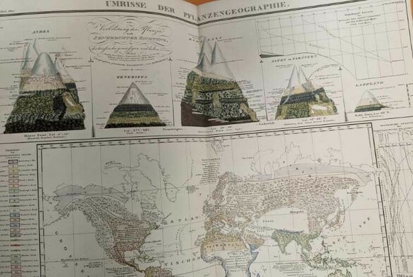
Wir durften im Rahmen der #FOSSGIS2023 in der Staatsbibliothek Karten einsehen.
Sehr interessant, weil dort von historischen bis hin zu aktuellen Karten zusammengtragen wird.
https://kartdok.staatsbibliothek-berlin.de/
Mir war bislang auch nicht bekannt, dass Bund und Länder dort eine Dokumentationspflicht für erstellte Kartenwerke haben. Dementsprechend ein Fundus für alle möglichen Kartenwerke, sofern die kartenerzeugenden Stellen sich dessen bewusst sind und lieferten.
#GIS #historicalmaps
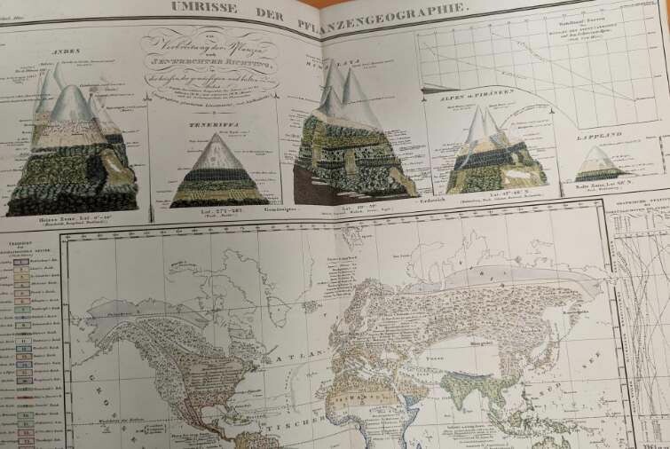
Humboldt Karte
#HistoricalMaps #gis #fossgis2023

The Voyager's Workshop · @wfgWorkshop
537 followers · 307 posts · Server mastodon.art
The Greater Asia map for the Animated History of Tibet documentary series is one of 5 maps of varying sizes and complexity that I have the privilege of creating. They will all be animated and used to support the narrative in very interesting ways. There’s still a long way to go but it’s really starting to take shape!
#mapmaking #cartography #historicalmaps #tibet
#tibet #HistoricalMaps #cartography #mapmaking