Dominique Derauw · @dderauw
33 followers · 27 posts · Server social.linux.pizza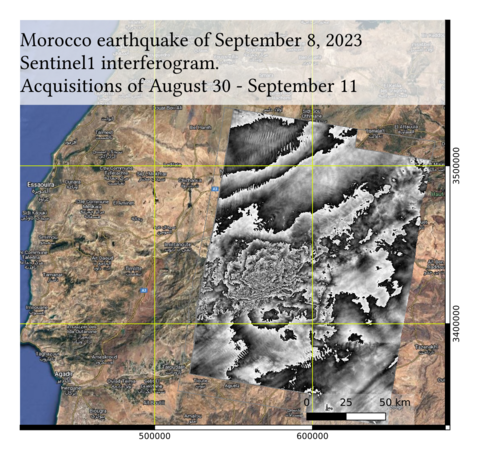
#ESA #Copernicus #Sentinel1 #InSAR interferogram of the postseismic displacements induced by the September 8 #Earthquake that occurred in #Morrocco between #Marakech and #Agadir.
If considering that movement is purely vertical and counting approx 5 fringes to the epicentre, it means a cumulated 15cm vertical displacement.
Processing made from #Sentinel1 SAR pair acquired on August 30 and September 11, 2023.
#MasTerEngine
#esa #copernicus #Sentinel1 #InSAR #earthquake #morrocco #marakech #agadir #MasTerEngine

InfoSondas · @infosondas
30 followers · 164 posts · Server astrodon.social
Documento. InSAR Missions at Enceladus. Concept Feasibility Study
https://www.infosondas.com/2023/06/documento-insar-missions-at-enceladus-concept-feasibility-study/

GregCocks · @GregCocks
270 followers · 355 posts · Server techhub.social
Land Around The U.S. [And Beyond] Is Sinking; Here Are Some Of The Fastest Areas
--
https://www.washingtonpost.com/climate-environment/2023/05/30/land-sinking-us-subsidence-sea-level/ <-- shared media article
--
https://doi.org/10.1038/s41893-022-00947-z <-- shared paper
--
https://doi.org/10.1029/2022GL098477 <-- shared paper
--
#GIS #spatial #mapping #remotesensing #INSAR #radar #survey #spatiotemporal #spatialanalysis #coast #coastalengineering #coastal #urbanplanning #climatechange #future #sustainable #accounting #economics #cost #impacts #sealevelrise #SLR #RSLR #engineeringgeology #shoreline #RLSS #urbanareas #cities #global #vulnerability #urbanplanning #coastalcommunities
#gis #spatial #mapping #remotesensing #InSAR #radar #survey #spatiotemporal #spatialanalysis #coast #coastalengineering #coastal #urbanplanning #climatechange #future #sustainable #accounting #economics #cost #impacts #sealevelrise #slr #rslr #engineeringgeology #shoreline #rlss #urbanareas #cities #global #vulnerability #coastalcommunities

Copernicus EU · @CopernicusEU
1786 followers · 7942 posts · Server respublicae.eu
RT @RagnarHeidar: Sea ice slowly making its way towards the Westfjords in the bitter cold northerly winds. This is #sentinel1 from yesterday
🐦🔗: https://n.respublicae.eu/CopernicusEU/status/1636428645702021121
berndandeweg · @berndandeweg
154 followers · 742 posts · Server mastodon.nl
Faramarz Nilfouroushan 🛰️📐🌏 · @farnil
137 followers · 8 posts · Server techhub.social
If you're interested in learning about our progress in installing corner reflectors in Sweden, as well as the validation of the Swedish Ground Motion service, please read our newly published report, which is available here.
https://www.lantmateriet.se/globalassets/geodata/gps-och-geodetisk-matning/rapporter/lantmaterirapport_2023-1.pdf
#InSAR #GMS

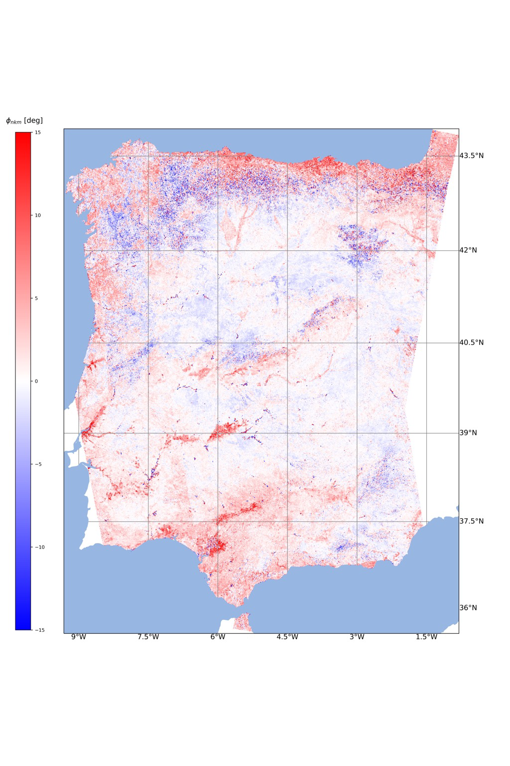
Yan Yuan · @YanYuan
3 followers · 2 posts · Server mapstodon.space
🤩Gradually covering the entire Iberian Peninsula with descending and ascending #Sentinel1 tracks! 🛰️The figure shows the annual mean of #closurephases in 2017 (VV). We are exploring the mystery of the geophysical origins 💦🏔️🌳and busy writing our results as articles! 👩🏻💻#InSAR
#Sentinel1 #closurephases #InSAR

Bob LeFridge · @BobLefridge
593 followers · 2760 posts · Server mastodon.nzWhat can we do about landslides? Stop building on cliff edges for a start, then use satellites to understand the ground surface movement in detail.
Some relevant thoughts from Martin Brook, associate professor of Applied Geology @ Auckland Uni.
Dr. Eric J. Fielding, PhD · @EricFielding
635 followers · 526 posts · Server mastodon.social#AGU22 #InSAR ARIA talk this morning by Grace Bato: "IN52A-05: Narrowing the Latency Gap for Disaster Response and Open Science: ARIA’s Analysis-Ready Displacement Data for Everyone"
will be recorded and online later
https://eppro01.ativ.me/appinfo.php?page=Session&project=AGU22&id=p1159601-134311&server=eppro01.ativ.me
Raphael Grandin · @RaphaelGrandin
303 followers · 180 posts · Server social.linux.pizza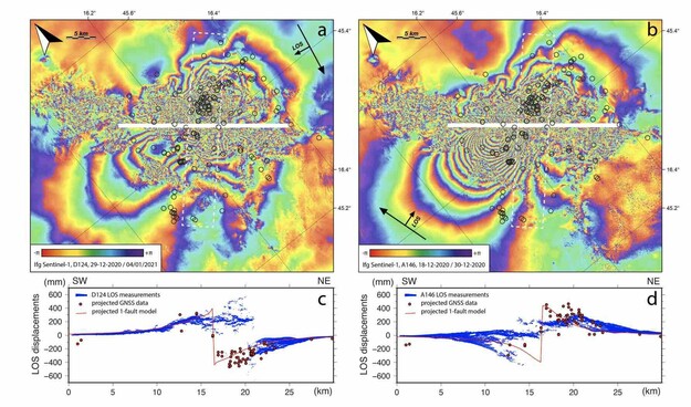
@dblm_m @Stef_EQ_Geology
This may be one of the few cases where the density of #GNSS measurements outperforms InSAR. Below is figure from the Supplement showing the decorrelation of #InSAR in the vicinity of the #earthquake #fault. Must have been a tedious job to conduct so many measurements in the field. Great work! Congratulations for this publication! 👍 But I am a bit disappointed that InSAR did not work so well on that one... 😥 🌈
#gnss #InSAR #earthquake #fault
Faramarz Nilfouroushan 🛰️📐🌏 · @farnil
86 followers · 7 posts · Server techhub.social
I am happy to share our new article which was just published in in Scientific Reports. #Iran #InSAR #subsidence #groundwater
rdcu.be/c1wAP
#Iran #InSAR #subsidence #groundwater
Dr. Eric J. Fielding, PhD · @EricFielding
516 followers · 418 posts · Server mastodon.socialJob opening:
Signal Analysis Engineer II in Pasadena, California, United States of America | Engineering at JPL (Jet Propulsion Laboratory)
#radar #insar #JPL #delta-X #engineering #signal #analysis #job
https://www.jpl.jobs/job/R3451/Signal-Analysis-Engineer-II
#radar #InSAR #jpl #delta #engineering #signal #analysis #job
Dr. Eric J. Fielding, PhD · @EricFielding
499 followers · 393 posts · Server mastodon.socialSee also the #InSAR surface displacement map in this post:
https://mastodon.social/@EricFielding/109434395287232299
Dr. Eric J. Fielding, PhD · @EricFielding
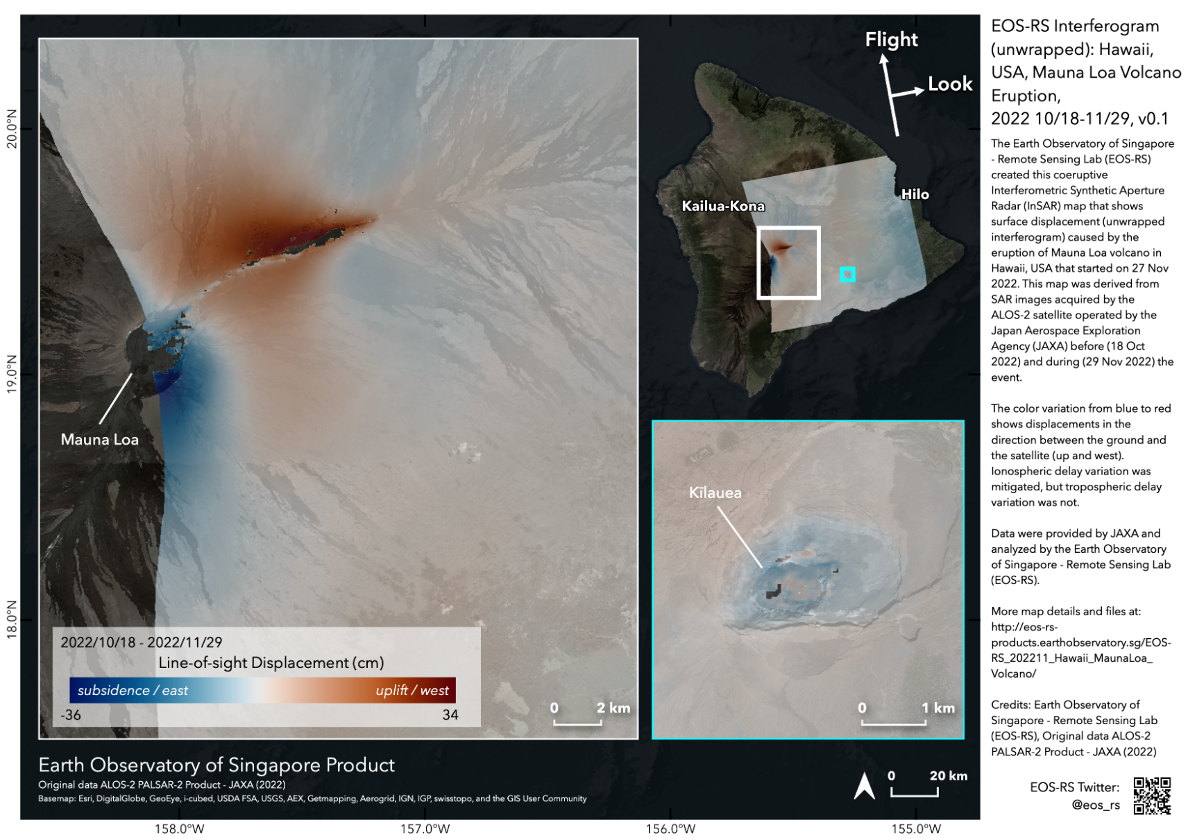
498 followers · 388 posts · Server mastodon.social
Our partners at the Earth Observatory of Singapore Remote Sensing lab made map of surface displacements for Mauna Loa #MaunaLoa east side from JAXA ALOS-2 radar images acquired yesterday and earlier this year. This #InSAR displacement map shows motion of surface to east and up in this case. The northeast rift zone has expanded due to new magma moving there and the summit has moved down during #volcano #eruption at (29 Nov 2022, 10:23 UTC).
Data products available at https://eos-rs-products.earthobservatory.sg/EOS-RS_202211_Hawaii_MaunaLoa_Volcano/
#maunaloa #InSAR #volcano #eruption
Raphael Grandin · @RaphaelGrandin
203 followers · 145 posts · Server social.linux.pizza@EricFielding Hi Eric! Is this product based on #InSAR coherence? Or derived from coherence change maybe?
Raphael Grandin · @RaphaelGrandin
185 followers · 131 posts · Server social.linux.pizza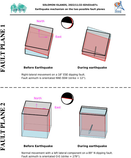
@jascha Hum the visualization of the block motion for this #earthquake is weird. Anyway, fault plane could be either vertical (dip=89°) or near-horizontal (dip=18°). Distinction between "normal" and "reverse" becomes blurred, I guess. I'd be curious to see the #Sentinel1 #InSAR.

Mohammad Mohseni Aref · @mohseniaref
30 followers · 5 posts · Server scicomm.xyz
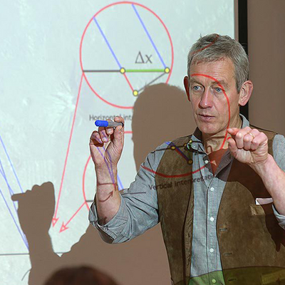
#InSAR time-series Andy Hooper https://twitter.com/GeoAndyHooper InSAR
#COMET Training Workshop 2022 (online)
Mohammad Mohseni Aref · @mohseniaref
30 followers · 5 posts · Server scicomm.xyz
Mohammad Mohseni Aref · @mohseniaref
30 followers · 5 posts · Server scicomm.xyz#InSAR time-series Andy Hooper @GeoAndyHooper InSAR Training Workshop 2022 (online)
Mohammad Mohseni Aref · @mohseniaref
30 followers · 5 posts · Server scicomm.xyz#InSAR time-series Andy Hooper @GeoAndyHooper InSAR Training Workshop 2022 (online)