
rimageweb · @rimageweb
2 followers · 105 posts · Server piaille.fr
Nouvelle version LTR de QGIS 3.28
#qgis #MapServer #GeoServer #MapBox #OpenLayers #gistribe #gischat #fossgis #foss4g #OSGeo #DataViz #opensource #spatial #geospatial #gis #geo #geoObserver
#qgis #MapServer #geoserver #mapbox #Openlayers #gistribe #gischat #fossgis #foss4g #osgeo #dataviz #opensource #spatial #geospatial #gis #geo #geoobserver
rimageweb · @rimageweb
2 followers · 104 posts · Server piaille.frNouvelle version LTR de QGIS 3.28
#qgis #MapServer #GeoServer #MapBox #OpenLayers #gistribe #gischat #fossgis #foss4g #OSGeo #DataViz #opensource #spatial #geospatial #gis #geo #geoObserver
#qgis #MapServer #geoserver #mapbox #Openlayers #gistribe #gischat #fossgis #foss4g #osgeo #dataviz #opensource #spatial #geospatial #gis #geo #geoobserver

GregCocks · @GregCocks
279 followers · 364 posts · Server techhub.social
UNVT Portable - Portable MapServers For Disaster Response
--
https://github.com/unvt/portable
--
" ‘UNVT Portable’ is a package for RaspberryPi that functions as a map hosting server and can be freely accessed from a web browser within a local network.
It is mainly intended to function in an offline environment during times of severe disaster, and is expected to play an active role... where disaster response headquarters are set up to assess the situation and respond to disasters by combining aerial drone images taken after a disaster occurs with OpenStreetMap and various open data tile data sets prepared in advance…”
#GIS #spatial #mapping #gischat #portable #mapserver #raspberrypi #raspberry #hosting #server #webbrowser #localnetwork #onsite #disasterresponse #hardware #solution #opensource #openformat #responsecenter #disasterresponsecenter #headquarters #readyresponse #mobile #mobileoffice #emergencyresponse #emergencymanagement #emergencypreparedness #risk #hazard #onlinemapping
#gis #spatial #mapping #gischat #portable #MapServer #raspberrypi #raspberry #hosting #server #webbrowser #localnetwork #onsite #disasterresponse #hardware #solution #opensource #openformat #responsecenter #disasterresponsecenter #headquarters #readyresponse #mobile #mobileoffice #emergencyresponse #emergencymanagement #emergencypreparedness #risk #hazard #onlinemapping
GregCocks · @GregCocks
192 followers · 242 posts · Server techhub.social
Springer Makes Open Source Chapter Of Upcoming Handbook Of Geographic Information Freely Accessible In April
--
https://link.springer.com/chapter/10.1007/978-3-030-53125-6_30 <-- shared journal issue
--
H/T Doug Newcomb
[a good overview of open source GIS software stacks]
“... As a service to the readers, the reference section of this chapter includes scientific video recordings which provide additional content regarding software capabilities, historical notes and background information: #Actinia, #GeoBlackLight, #GeoPaparazzi, #GeoPython, #GeoServer, #GeoTools, #GMT, #GRASSGIS, #gvSIG, #JTS, #Leaflet, #MapServer, #NASAWorldWind, #OSGeoLive. #PostGIS, #PROJ, #QGIS, #rasdaman. In addition, scientific videos about the #OSGeo Foundation and the annual #SolKatzAwards or #GeospatialFreeandOpenSourceSoftware are included…”
#GIS #spatial #mapping #free #opensource #software #FOSS #opensourcesoftware #algorithms #geospatialtechnology #postgresql #postgres #softwarestacks
#actinia #geoblacklight #geopaparazzi #geopython #geoserver #geotools #gmt #grassgis #gvsig #jts #leaflet #MapServer #nasaworldwind #osgeolive #postgis #proj #qgis #rasdaman #osgeo #solkatzawards #geospatialfreeandopensourcesoftware #gis #spatial #mapping #free #opensource #software #foss #OpenSourceSoftware #algorithms #geospatialtechnology #PostgreSQL #postgres #softwarestacks

Tom Chadwin · @tomchadwin
163 followers · 214 posts · Server en.osm.townCan anyone point me towards info on #MapServer release supported life? Trying to do some medium-term planning, and wondering when our current version will no longer be supported.

MapAm💜re · @MapAmore
523 followers · 1021 posts · Server en.osm.town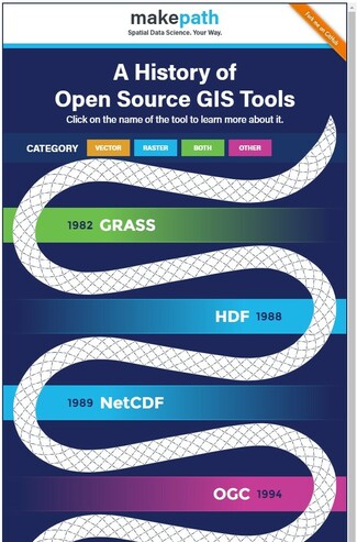
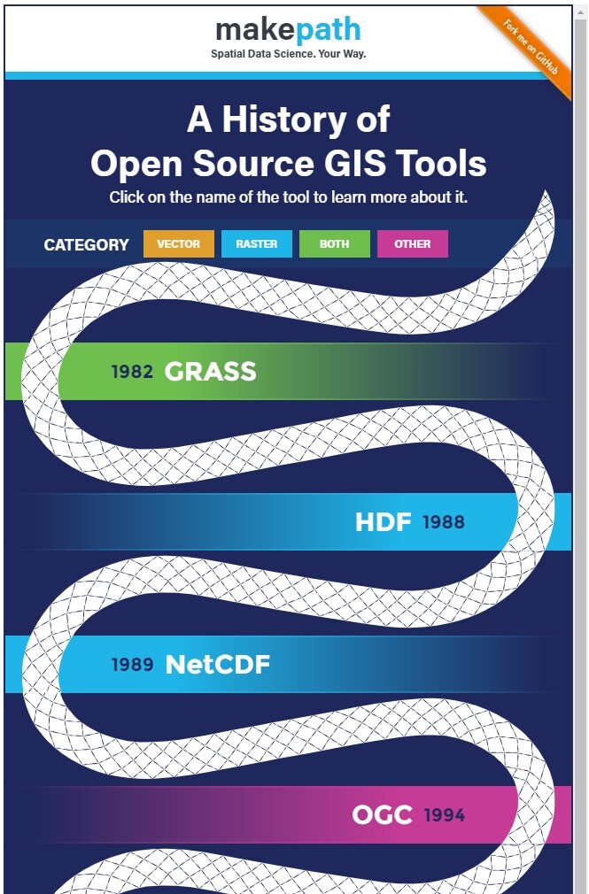
RT @gregcocks_kiwi
The History of Open Source GIS - An Interactive Infographic
https://makepath.com/history-of-open-source-gis/
#GIS #spatial #opensource #crowdsource #history #INFOGRAPHIC
#GRASS @opengeospatial #MapServer #GML #GDAL #GeoServer #KML #QGIS #NumPy #Shapely #Leaflet #Fiona #GeoPackage #Cartopy #GeoPandas
#gis #spatial #opensource #crowdsource #history #infographic #grass #MapServer #GML #gdal #geoserver #KML #qgis #numpy #Shapely #leaflet #Fiona #geopackage #Cartopy #Geopandas