Genuinely Gary 🌤️ · @sgtgary
759 followers · 2753 posts · Server mindly.socialThat weak frontal boundary looks tantalizingly close to us this afternoon... wel could use the cool-down in Nebraska and Iowa please #NEwx #IAwx https://on.windy.com/87kuf
Genuinely Gary 🌤️ · @sgtgary
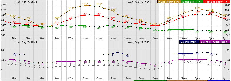
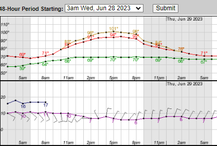
753 followers · 2727 posts · Server mindly.socialTomorrow is the peak of the oppressive heat in eastern Nebraska with a high temperature around 101°F, an expected dew point around 80°F and a heat index of around 119°F. I haven't felt this kind of weather since a summer deployment in Qatar #NEwx
Genuinely Gary 🌤️ · @sgtgary
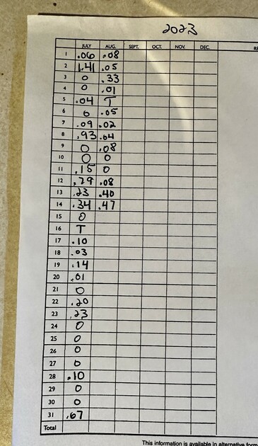
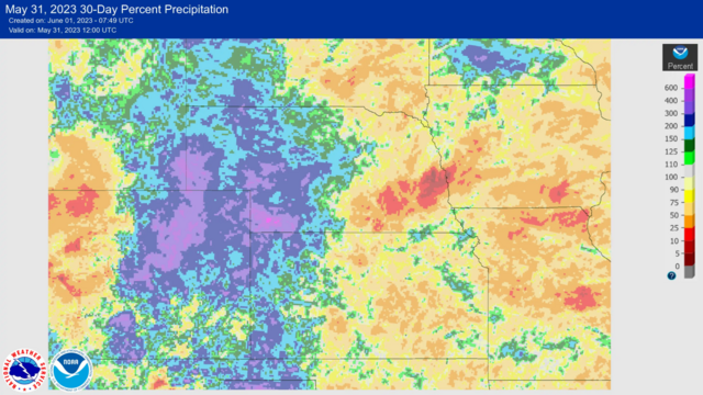
745 followers · 2701 posts · Server mindly.socialMy rain gauge has been incredibly busy since early June. It’s a nice change from the serious drought we had in the first half of the year #NEwx.
Genuinely Gary 🌤️ · @sgtgary
718 followers · 2621 posts · Server mindly.socialGenuinely Gary 🌤️ · @sgtgary
715 followers · 2605 posts · Server mindly.socialGenuinely Gary 🌤️ · @sgtgary
715 followers · 2605 posts · Server mindly.socialGenuinely Gary 🌤️ · @sgtgary
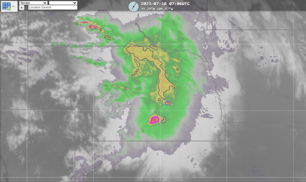
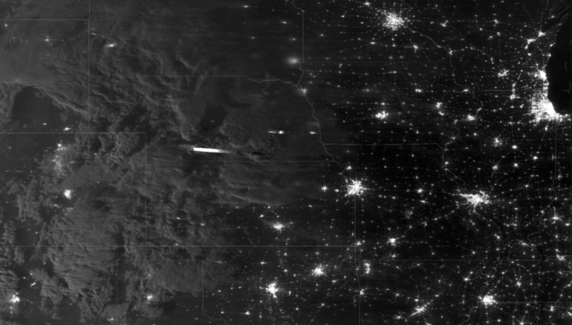
703 followers · 2555 posts · Server mindly.socialThe NOAA-20 nighttime VIIRS imagery captured the mass of storms (and a couple of lightning strikes) in Nebraska overnight #NEwx
Genuinely Gary 🌤️ · @sgtgary
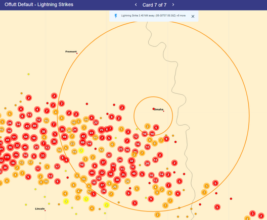
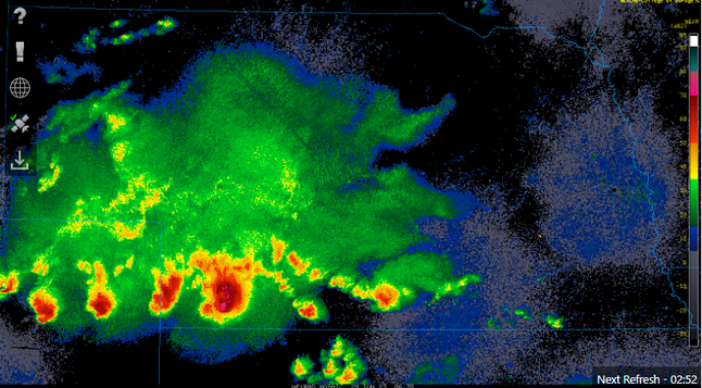
703 followers · 2542 posts · Server mindly.socialThe lightning show has reached Omaha #NEwx. This chart shows lightning detected over the last 10 minutes. Also showing the associated base reflectivity radar image
Genuinely Gary 🌤️ · @sgtgary
703 followers · 2540 posts · Server mindly.socialGenuinely Gary 🌤️ · @sgtgary
701 followers · 2536 posts · Server mindly.socialToday is the hottest day of the yea so far in Omaha - 95°F with a heat index of 101°F.
And yet it's nothing compared to the temperatures of those to our south all the way to the Gulf Coast. #NEwx
Genuinely Gary 🌤️ · @sgtgary
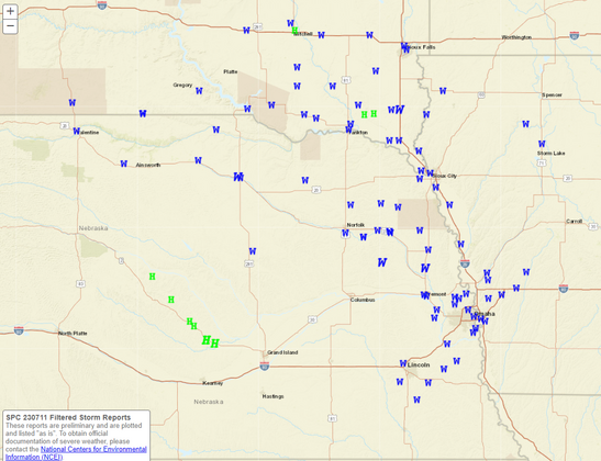
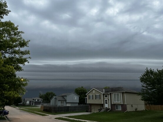
701 followers · 2527 posts · Server mindly.socialStorms developing across central Nebraska have the potential to produce severe winds through eastern Nebraska this morning. #NEwx
Genuinely Gary 🌤️ · @sgtgary
691 followers · 2479 posts · Server mindly.socialWe finally reached the cycle of afternoon, thundershower development, and I love that they’re traveling the opposite of the “normal” direction. #NEwx
Genuinely Gary 🌤️ · @sgtgary
681 followers · 2471 posts · Server mindly.socialGenuinely Gary 🌤️ · @sgtgary
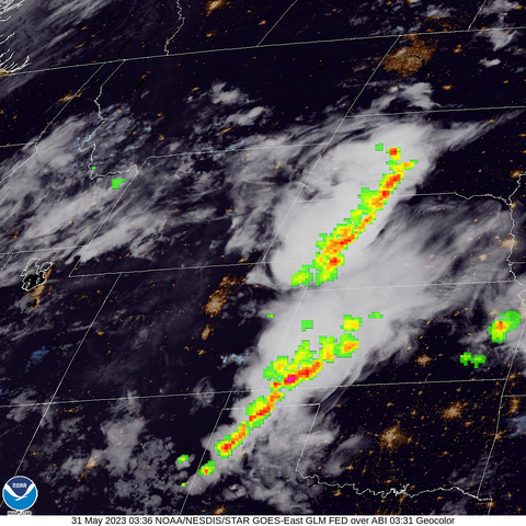
672 followers · 2452 posts · Server mindly.socialGreat Plains nocturnal thunderstorm season... Nebraska and Kansas really need the rain! #KSwx #NEwx
Full animated loop can be found here: https://www.star.nesdis.noaa.gov/GOES/sector_band.php?sat=G16§or=nr&band=EXTENT3&length=24
Genuinely Gary 🌤️ · @sgtgary
660 followers · 2428 posts · Server mindly.socialSo far in May, Omaha's average temperature is +2.8°F from normal (+3.8°F from normal in Valley) with a rainfall deficit presently at 3.28" below normal #NEwx
Genuinely Gary 🌤️ · @sgtgary
659 followers · 2417 posts · Server mindly.socialNational Weather Service Minimum Temperature Forecast and departure from climatology valid Saturday May 20th. A swath of cooler air runs through the Plains and upper Midwest while above average temperatures continue in the West.
Today felt amazing outside and tomorrow morning will be a tiny bit chilly in Omaha #NEwx
Genuinely Gary 🌤️ · @sgtgary
650 followers · 2361 posts · Server mindly.socialGenuinely Gary 🌤️ · @sgtgary
650 followers · 2350 posts · Server mindly.socialSometimes the HRRR model data is so uncannily accurate! It leads me sometimes to believe it's usually right, even when it's wrong. However, tonight's 02Z forecast for radar data shows the rain and storms are right about where they actually are *right now* Great forecast with a 5-hour lead time. 👍 #NEwx
Genuinely Gary 🌤️ · @sgtgary
650 followers · 2346 posts · Server mindly.socialWell Nebraska May weather has entered the chat...
Fairly typical to see storms in May and June here. This is our typical severe weather season, though these storms are only slight risk of severe weather. #NEwx
Genuinely Gary 🌤️ · @sgtgary
649 followers · 2336 posts · Server mindly.socialSome weak thunderstorms and showers persist across much of northern and western Nebraska tonight #NEwx
