
Rony Nedkov · @rony
20 followers · 9 posts · Server mapstodon.spaceInterested in the why, what and how behind my new side project https://mapstyler.com?
I wrote a blog post. https://www.oneprojectatatime.nl/launching-mapstyler/
#WebGIS #geospatial #Openlayers #gischat #postgis

rimageweb · @rimageweb
2 followers · 105 posts · Server piaille.fr
Nouvelle version LTR de QGIS 3.28
#qgis #MapServer #GeoServer #MapBox #OpenLayers #gistribe #gischat #fossgis #foss4g #OSGeo #DataViz #opensource #spatial #geospatial #gis #geo #geoObserver
#qgis #MapServer #geoserver #mapbox #Openlayers #gistribe #gischat #fossgis #foss4g #osgeo #dataviz #opensource #spatial #geospatial #gis #geo #geoobserver
rimageweb · @rimageweb
2 followers · 104 posts · Server piaille.frNouvelle version LTR de QGIS 3.28
#qgis #MapServer #GeoServer #MapBox #OpenLayers #gistribe #gischat #fossgis #foss4g #OSGeo #DataViz #opensource #spatial #geospatial #gis #geo #geoObserver
#qgis #MapServer #geoserver #mapbox #Openlayers #gistribe #gischat #fossgis #foss4g #osgeo #dataviz #opensource #spatial #geospatial #gis #geo #geoobserver

Alex Leith · @alexgleith
169 followers · 84 posts · Server mapstodon.spaceRT @giswqs
Introducing a new #Python package called mapwidget - creating interactive 3D maps in a Jupyter environment using popular JavaScript libraries, such as #CesiumJS, #Mapbox, #MapLibre, #Leaflet, and #OpenLayers
#python #cesiumjs #mapbox #maplibre #leaflet #Openlayers #geospatial #gischat #anywidget
Adam Cox · @mradamcox
17 followers · 5 posts · Server mapstodon.spaceIntro! Happy to be here on mastodon and meeting new people! I am a geospatial developer most interested in #FOSS4G and new applications of #HistoricalMaps and #digitalhum geo things like that. Currently I'm mainly using #qgis #django #python #svelte #geoserver #Openlayers and #titiler.
My current project is a #crowdsourcing site for georeferencing #Sanborn fire insurance maps of US cities: https://oldinsurancemaps.net. I'm reworking it now but there is still a LOT to see there :))
#FOSS4G #HistoricalMaps #digitalhum #qgis #django #python #svelte #geoserver #Openlayers #titiler #crowdsourcing #sanborn

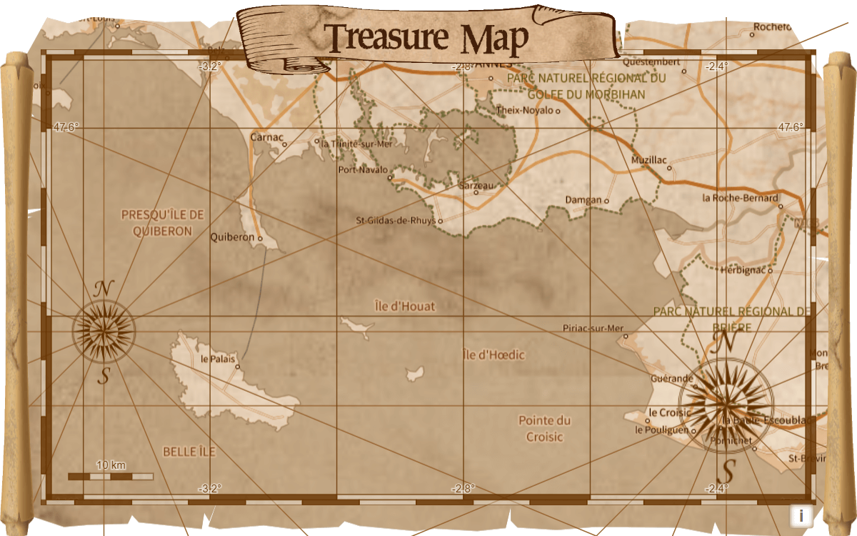
JMViglino · @jmviglino
16 followers · 3 posts · Server mapstodon.space
#30DayMapChallenge - Day 20 - My favorite
🏴☠️ Treasure map! 🇫🇷 Carte au trésor ! ☠️
🦜 Easter egg inside‼️🐰🥚
⁉️ clue: it's a "vanne" (french joke) 🤭
🗺️#olext #Openlayers 🌍 #OpenSource
https://viglino.github.io/MapChallenge2022/day20.html
#30DayMapChallenge #olext #Openlayers #opensource

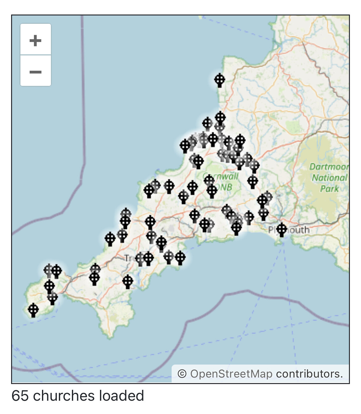
Dr Dean Jenkins · @dean_jenkins
5 followers · 7 posts · Server mastodon.world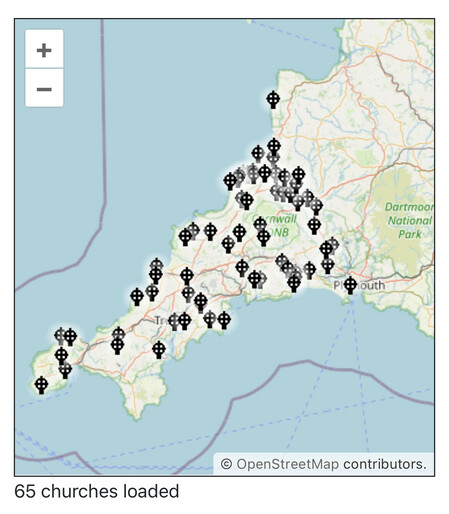
Coding this new project of Cornish churches.
https://celticquietplaces.com/
Hope to launch early next year. Comments very welcome. #cornwall
Built with #OpenLayers and #ReactJS
#cornwall #Openlayers #reactjs
JMViglino · @jmviglino
16 followers · 3 posts · Server mapstodon.space#30DayMapChallenge - Day 8 - OSM
🚍Use Overpath ol-ext layer source to display bus stops on a #map 🗺️#olext #Openlayers 🌍 #OpenSource #Overpass #API
https://viglino.github.io/MapChallenge2022/day8.html
#30DayMapChallenge #map #olext #Openlayers #opensource #Overpass #api
JMViglino · @jmviglino
16 followers · 3 posts · Server mapstodon.space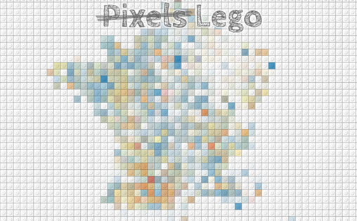
#30DayMapChallenge day 7 - ̵r̵a̵s̵t̵e̵r̵ ̵p̵i̵x̵e̵l̵s̵ Lego
🧱#Lego filter to create a #map of the average housing area using
@InseeFr
data 🗺️#olext 🌍
Challenge: use ol-ext and #Openlayers
▶️ https://viglino.github.io/MapChallenge2022/day7.html
#30DayMapChallenge #lego #map #olext #Openlayers