Maddy · @shyminn
1 followers · 2 posts · Server en.osm.townMap collection coming along nicely 👀 mostly #OrdnanceSurvey 7th and early 8th series
dabbler · @dabbler
4 followers · 8 posts · Server en.osm.townOrdnance Survey maps are the best printed maps I have ever seen. Some of their data has been made available for free download, now I "merely" need to find out how/if I can use them.🤔
Are there any ready-to-use "apps" that can use/display these data files?
Free OS OpenData Map Downloads | Free Vector & Raster Map Data
#OrdnanceSurvey #opendata #maps
BBC 6 Music 🎶 #NowPlaying Bot · @BBC6MusicBot
856 followers · 39761 posts · Server mastodonapp.uk🔊 #NowPlaying on #BBC6Music's #StuartMaconiesFreakZone
Ordnance Survey:
🎵 Nomos Part III - An Phadair
https://open.spotify.com/track/7iCwtyg3Oiu0V1HKammf35
https://scintillarecordings.bandcamp.com/track/part-iii-an-phadair
#nowplaying #bbc6music #StuartMaconiesFreakZone #OrdnanceSurvey
SK53 · @SK53
95 followers · 278 posts · Server en.osm.townOld #WindMills on #Anglesey: using the place name data from old #OrdnanceSurvey maps collected by #GB1900 to add things (windmills) to #OpenStreetMap
https://www.openstreetmap.org/user/SK53/diary/401114
Images from : https://commons.wikimedia.org/wiki/Category:Windmills_in_Anglesey
#windmills #anglesey #OrdnanceSurvey #gb1900 #OpenStreetMap
East Midlands OpenStreetMap · @FiveBoroughsOSM
2 followers · 3 posts · Server en.osm.townIllustrated by screen grabs of #OpenCycleMap and #Sustrans overlay on the #OrdnanceSurvey OSMaps base layer (partially OSM).
Here the issues are straightforward: an unsigned revision, apparently still awaiting the council spending ~£1 million allocated for the project in early 2020: https://www.nottinghampost.com/news/nottingham-news/almost-1m-spent-improving-nottinghams-3728038
2/n
#opencyclemap #Sustrans #OrdnanceSurvey
JdeBP · @JdeBP
80 followers · 2015 posts · Server mastodonapp.uk@TerribleMaps , I would like to request a 1:625000 Ordnance Survey map of Great Britain, viewed in the near infra-red.
#mapofgreatbritain #OrdnanceSurvey
SK53 · @SK53
87 followers · 245 posts · Server en.osm.townMight be old news to some, but #OrdnanceSurvey Terrain50 elevation #OpenData has different resolutions in vector & raster formats: https://sk53-osm.blogspot.com/2023/01/a-little-surprise-hidden-in-os.html.
Vector data will be good enough for most apps wanting contour data in Great Britain.
Thanks to @nigelparrish for setting me off down this rabbit hole.
SK53 · @SK53
87 followers · 245 posts · Server en.osm.townOpenStreetMap does not hold contour data. Your example is is Thunderforest Outdoors:
https://www.thunderforest.com/maps/outdoors/
Maps built from OSM tend to use available open source elevation data, usually SRTM 'cos it has worldwide coverage.
#OrdnanceSurvey do provide some open elevation data (Terrain50), it's not really any better as rasters (image 1), unexpectedly a lot better as vector data (image 2). Third image is from DEFRA 1m Lidar. Last all 3. OSM basemap by @SomeoneElse
SK53 · @SK53
75 followers · 96 posts · Server en.osm.townPlaying around with slopes from #OrdnanceSurvey Open Terrain50 and paths from #OpenStreetMap in #QGIS and #PostGis with a view to reviewing ones which may lead to walkers getting #CragFast
#OrdnanceSurvey #OpenStreetMap #qgis #postgis #cragfast
James Brown · @JamesGABrown
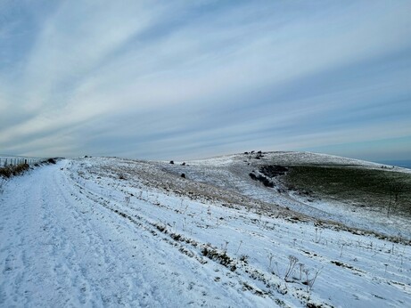
418 followers · 57 posts · Server mastodonapp.ukA snow covered Wolstonbury Hill for #HillfortsWednesday. #BronzeAge Ram's Hill type enclosure with unusual feature of an internal boundary ditch. Enclosure potmarked with C18th flint digging, but evidence of Iron Age, Roman & Saxon activity has been noted. #HeritageHound had a quick survey of the site from the #OrdnanceSurvey #TrigPoint.
#Archaeology #archaeodon #Sussex https://historicengland.org.uk/listing/the-list/list-entry/1016153?section=official-list-entry
#HillfortsWednesday #bronzeage #HeritageHound #OrdnanceSurvey #trigpoint #archaeology #archaeodon #sussex
Timepix · @timepix
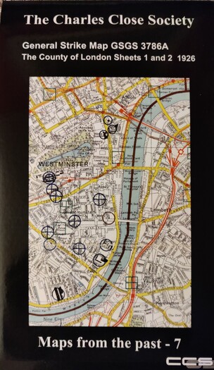
125 followers · 200 posts · Server mastodonapp.ukDelighted to receive this repro #Secret 1926 #GeneralStrike #map of #London today. It was produced to inform the emergency response to the strike and this copy is printed by the wonderful #DennisMaps to full #OrdnanceSurvey standard for the #CharlesCloseSociety https://charlesclosesociety.org/home
#secret #generalstrike #map #london #DennisMaps #OrdnanceSurvey #CharlesCloseSociety
Timepix · @timepix
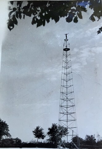
125 followers · 201 posts · Server mastodonapp.ukOK, so you know the #TrigPillar s on top of hills and mountains? Used by #OrdnanceSurvey to create a framework for it's #maps. Now think about the flatlands of East Anglia, here artificial hills were created using temporary 'Bilby towers' Here one of the OS surveyors is demonstrating their lack of fear of heights 😨 (look no safety harness) 1950s
#trigpillar #OrdnanceSurvey #maps
Judith · @aroundthehills
97 followers · 201 posts · Server mastodonapp.ukI've learned a word: Pheon
This is a lovely blog post all about #OrdnanceSurvey #Benchmarks.
Jaana Pinnick · @NottsFinn
59 followers · 29 posts · Server mastodonapp.ukA tiring week over, but a lot of good work done. #digipres workshop, #DataGovernance course completed, #RDM #training course delivered and #RDA and #EOSC #DataStewardship meetings attended. Now some downtime before next week’s visit to #OrdnanceSurvey
#digipres #DataGovernance #rdm #training #rda #EOSC #DataStewardship #OrdnanceSurvey
Tetuan22s · @tetuan22s
320 followers · 188 posts · Server mastodonapp.ukIs this a Ordnance Survey/GPO benchmark? By The Purlieu West Malvern #benchmark #OS #OrdnanceSurvey #Malvern
#benchmark #os #OrdnanceSurvey #Malvern
Judith · @aroundthehills
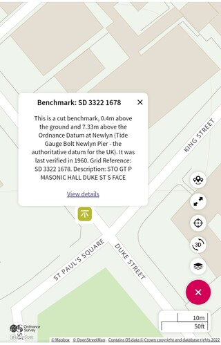
83 followers · 152 posts · Server mastodonapp.ukInteresting #OrdnanceSurvey #Benchmarks on the Masonic Hall in Southport.
The first, quite tatty one, is where the OS says it should be on Duke Street. The other beautifully cut one is on the East-facing gatepost on King Street.
Judith · @aroundthehills
80 followers · 143 posts · Server mastodonapp.ukInteresting #OrdnanceSurvey #Benchmarks on the Masonic Hall in Southport.
The first, quite tatty one, is where the OS says it should be on Duke Street. The other beautifully cut one is on the East-facing gatepost on King Street.
· @gpsbaby
0 followers · 1 posts · Server mastodonapp.uk#Introduction hi brave new bird alt. Following the suggested protocols … had the pleasure of being at the birth of commercial #gps in 1984 - worked on the first differential services and then moved to work for the main receiver manufacturer at the time #Trimble. Since then focussed on maps and surveying ending up leading the mapping of GB for nearly 18 years at #ordnancesurvey. Now working on supporting new mappers and mapping technology . What can I say ♥️ maps ♥️ gps ♥️ map posts .
#introduction #gps #Trimble #OrdnanceSurvey
Timepix · @timepix
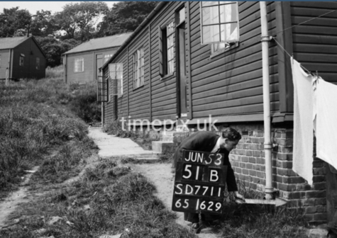
94 followers · 141 posts · Server mastodonapp.ukOld #1950s #oldphoto of Lowercroft Camp, near #Ainsworth.
Link takes you to about a dozen photos of the camp as surveyed by #OrdnanceSurvey in 1953.
Italian #POW camp in #WW2 it was then used for temporary housing for a few years. https://www.timepix.uk/keyword/Lowercroft%20Camp/i-xNK7RtP
#1950s #oldphoto #Ainsworth #OrdnanceSurvey #POW #ww2
· @CjMalone
46 followers · 240 posts · Server en.osm.town#OrdnanceSurvey is both releasing more #OpenData and using #OpenStreetMap formats...
Suggests they're not scared of OSM's data, but it's tooling and developer market share.
#OrdnanceSurvey #opendata #OpenStreetMap


