
@Eric.B ©️ · @u4y0u
132 followers · 291 posts · Server mastouille.fr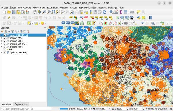
UPDATE Version avec l'ensemble des éléments #ZAPM, #NRO,#PMZ,#NRA sur une carte couleur réunissant les données #ARCEP et #OSM 🌍 pour l'ensemble du territoire national 🇫🇷 au 05/03/2023
Le fichier du projet utilisable sur smartphone 📱 avec #QField ou sur PC💻 avec #QGIS:
https://www.data.gouv.fr/fr/datasets/r/cdb4c712-8e2c-490d-9fd3-ba5dfdf2f033
utilisation avec QField:
https://github.com/u4y0u/Using-QField/blob/main/Using_QField.md
#FttH 2022T3
#fibreoptique #THD #opticalfiber
#zapm #nro #pmz #NRA #arcep #osm #qfield #QGIS #FTTH #fibreoptique #thd #opticalfiber

beyondwatts · @beyondwatts
210 followers · 290 posts · Server beyondwatts.social
@underdarkGIS @jon_neufeld @geomenke @tjukanov
Thanks for the mention 👍
@30DayMapChallengeBot helps share #30DayMapChallenge content across the Fediverse
And am building up a set of 'Behind the Scenes' posts @ https://www.beyondwatts.com/
with background details for some of my visualisations
#BehindTheScenes #Blender #python #qgis #dataviz #javascript #geospatial
#behindthescenes #Blender #python #QGIS #dataviz #javascript #geospatial #30DayMapChallenge
@Eric.B ©️ · @u4y0u
113 followers · 235 posts · Server mastouille.fr
UPDATE Version avec l'ensemble des éléments #ZAPM, #NRO,#PMZ,#NRA sur une carte couleur réunissant les données #ARCEP et #OSM 🌍 pour l'ensemble du territoire national 🇫🇷 au 13/01/2023
Le fichier du projet utilisable sur smartphone 📱 avec #QField ou sur PC💻 avec #QGIS:
https://www.data.gouv.fr/fr/datasets/r/cdb4c712-8e2c-490d-9fd3-ba5dfdf2f033
utilisation avec QField:
https://github.com/u4y0u/Using-QField/blob/main/Using_QField.md
#FttH 2022T3
#fibreoptique #THD #opticalfiber
#zapm #nro #pmz #NRA #arcep #osm #qfield #QGIS #FTTH #fibreoptique #thd #opticalfiber
@Eric.B ©️ · @u4y0u
114 followers · 219 posts · Server mastouille.fr
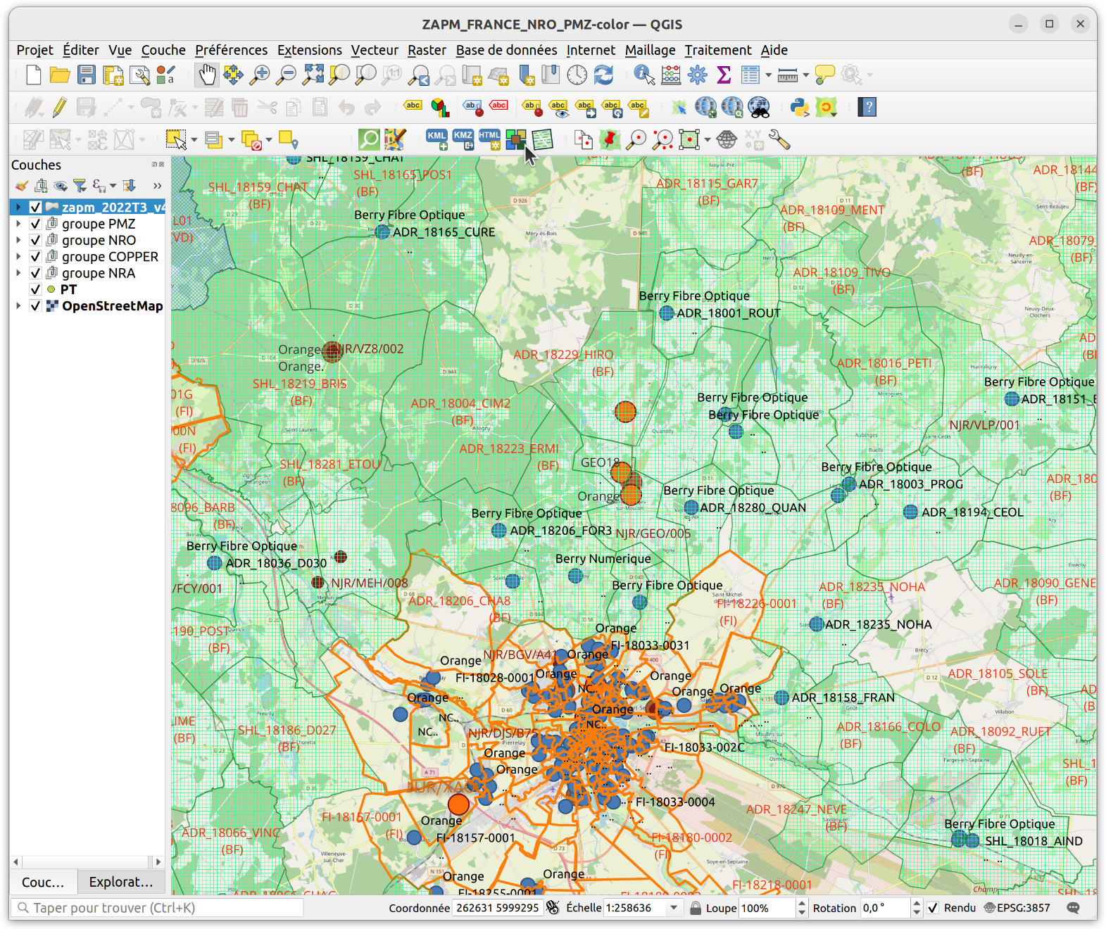
ZAPM FRANCE NRO PMZ - Cartographie du réseau fibre optique.
Mise à jour partielle armoires fibres #PMZ
https://github.com/u4y0u/ZAPM_FRANCE_NRO_PMZ
#pmz #FTTH #fibreoptique #arcep #thd #osm #qfield #QGIS
@Eric.B ©️ · @u4y0u
100 followers · 176 posts · Server mastouille.fr
UPDATE Version avec l'ensemble des éléments #ZAPM, #NRO,#PMZ,#NRA sur une carte couleur réunissant les données #ARCEP et #OSM 🌍 pour l'ensemble du territoire national 🇫🇷 au 02/01/2023
Le fichier du projet utilisable sur smartphone 📱 avec #QField ou sur PC💻 avec #QGIS:
https://www.data.gouv.fr/fr/datasets/r/cdb4c712-8e2c-490d-9fd3-ba5dfdf2f033
utilisation avec QField:
https://github.com/u4y0u/Using-QField/blob/main/Using_QField.md
#FttH 2022T3
#fibreoptique #THD #opticalfiber
#zapm #nro #pmz #NRA #arcep #osm #qfield #QGIS #FTTH #fibreoptique #thd #opticalfiber
@Eric.B ©️ · @u4y0u
91 followers · 167 posts · Server mastouille.fr[#vidéo] 🎥
Cartographie du réseau #fibre #optique, aperçu de l'utilisation du jeu de fichiers du projet ZAPM, version avec l'ensemble des éléments #ZAPM,
#NRO,#PMZ,#NRA sur une carte couleur réunissant les données #ARCEP et #OSM 🌍 pour l'ensemble du territoire national 🇫🇷
Le fichier du projet est utilisable sur smartphone 📱 avec #QField ou sur PC💻 avec #QGIS
#video #fibre #optique #zapm #nro #pmz #NRA #arcep #osm #qfield #QGIS
@Eric.B ©️ · @u4y0u
58 followers · 134 posts · Server mastouille.fr
Mise à jour partielle armoires fibres #PMZ
https://github.com/u4y0u/ZAPM_FRANCE_NRO_PMZ
#pmz #FTTH #fibreoptique #arcep #thd #osm #qfield #QGIS
@Eric.B ©️ · @u4y0u
56 followers · 113 posts · Server mastouille.fr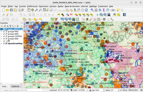
UPDATE Version avec l'ensemble des éléments #ZAPM, #NRO,#PMZ,#NRA sur une carte réunissant les données #ARCEP et #OSM pour l'ensemble du territoire national au 23/12/2022
Le fichier du projet utilisable sur smartphone #QField & #QGIS:
https://www.data.gouv.fr/fr/datasets/r/cdb4c712-8e2c-490d-9fd3-ba5dfdf2f033
#FttH 2022T3
#fibreoptique #THD #OSM #QGIS
#zapm #nro #pmz #NRA #arcep #osm #qfield #QGIS #FTTH #fibreoptique #thd
@Eric.B ©️ · @u4y0u
55 followers · 103 posts · Server mastouille.fr
ZAPM FRANCE NRO PMZ - Cartographie du réseau fibre optique.
mise à jour partielle #PMZ
#pmz #osm #QGIS #fibreoptique #nro #telco
@Eric.B ©️ · @u4y0u
44 followers · 75 posts · Server mastouille.fr

@Eric.B ©️ · @u4y0u
1 followers · 2 posts · Server mastouille.fr
UPDATE Version avec l'ensemble des éléments #ZAPM, #NRO,#PMZ,#NRA sur une carte réunissant les données #ARCEP et #OSM pour l'ensemble du territoire national au 16/12/2022
Le fichier du projet utilisable sur smartphone #QField & #QGIS:
https://www.data.gouv.fr/fr/datasets/r/cdb4c712-8e2c-490d-9fd3-ba5dfdf2f033
#FttH 2022T3
#zapm #nro #pmz #NRA #arcep #osm #qfield #QGIS #FTTH

Mark Walters · @markwalters
357 followers · 299 posts · Server mastodon.online
Found that there is a plugin in #QGIS for downloading the Campania, Italy #lidar so I had a play with that and saved the DSM geotiff to open in Planlauf Terrain. Here's Pompeii at 1 metre resolution #pompeii #archaeology #ancienthistory
#ancienthistory #archaeology #pompeii #lidar #QGIS
Mark Stosberg · @markstos
47 followers · 278 posts · Server mastodon.online
How to create a missing sidewalk map in QGIS. https://mark.stosberg.com/how-to-create-a-missing-sidewalk-map-in-qgis/
#urbanplanning #transpoequity #mapping #QGIS #GIS

beyondwatts · @beyondwatts
167 followers · 100 posts · Server beyondwatts.social1. In #QGIS, create a bounding box for the area you're interested in
2. Use the #QuickOSM plugin to download the #OpenStreetMap features
3. create a #ShapeFile using "Export->Save Features As..."
#QGIS #quickosm #OpenStreetMap #shapefile
beyondwatts · @beyondwatts
164 followers · 89 posts · Server beyondwatts.socialDay 8 - OSM was beer o'clock with @weeklyOSM data
A chance to use #Blender #GeometryNodes to distribute some beer glasses around #London
#Blender #geometrynodes #london #30DayMapChallenge #QGIS #Blender3d
beyondwatts · @beyondwatts
164 followers · 88 posts · Server beyondwatts.socialMy own creations have been mainly made in #Blender #Blender3d #QGIS #python and the odd bit of #javascript
I'll be writing some 'Behind the Scenes' posts at http://www.beyondwatts.com in the coming days and will add to this thread when they're available
#Blender #Blender3d #QGIS #python #javascript
beyondwatts · @beyondwatts
159 followers · 77 posts · Server beyondwatts.social
Barfleur is one of the largest ships to regularly enter #Poole harbour sailing regularly to #Cherbourg. Services were suspend during #covid and she was welcomed back afterwards. Have added smoke from the funnels and passenger lights - details that I didn't have time to add on the orginal animation ⬆️
#30DayMapChallenge Day 27 - #3D
Made with #Blender #Blender3d #QGIS #python #javascript
#poole #cherbourg #covid #30DayMapChallenge #3d #Blender #Blender3d #QGIS #python #javascript
beyondwatts · @beyondwatts
153 followers · 61 posts · Server beyondwatts.social
Poole Harbour Islands for
#30DayMapChallenge Day 26 - Islands
#30DayMapChallenge #QGIS #Blender #gis #map #dataviz #lidar
beyondwatts · @beyondwatts
134 followers · 45 posts · Server beyondwatts.social#30DayMapChallenge Day 23 - Movement
A day of ship movements in Bournemouth Bay and Poole Harbour. AIS data captured with #raspberrypi dAIShat receiver and supplemented with #AISHub. Streetlights generated from #OSM road network data. It’s been a background project for most of the year…
#30DayMapChallenge #raspberrypi #aishub #osm #Blender #QGIS #python #javascript #gis #dataviz
beyondwatts · @beyondwatts
128 followers · 35 posts · Server beyondwatts.social#TourOfBritain Stage 8 Isle of Wight route map. Another stage on our local roads that was understandably cancelled this year. It would have been epic 😢
#Sound On
#30DayMapChallenge Day 18 - Blue
Made with #Blender #QGIS #python #gis #dataviz
#TourOfBritain #Sound #30DayMapChallenge #Blender #QGIS #python #gis #dataviz