EU DELEGATION_ROME · @eudeleg_rome
4 followers · 1566 posts · Server respublicae.euRT Copernicus EU
#ImageOfTheDay
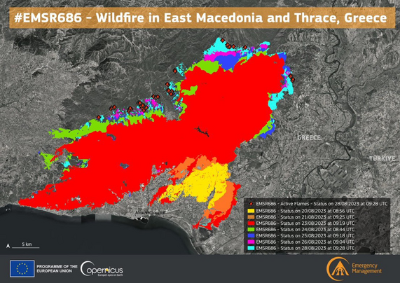
The #Αλεξανδρουπολης #Alexandroupolis🇬🇷 #Wildfires continue to rage in #Greece
🔴The burnt area has reached 7⃣7⃣,0⃣0⃣0⃣ ha with 1⃣2⃣0⃣ 🔥active hot spots
The @CopernicusEMS #RapidMappingTeam is working 24/7 on mapping products
http://rapidmapping.emergency.copernicus.eu/EMSR686
#EMSR686
🐦🔗: https://n.respublicae.eu/CopernicusEU/status/1695712813052735937
#ImageOfTheDay #Αλεξανδρουπολης #Alexandroupolis #wildfires #Greece #RapidMappingTeam #EMSR686
Velocity22 🏴☠️ · @Velocity2222
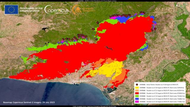
1323 followers · 8236 posts · Server libretooth.grOur #RapidMappingTeam delivered its 6⃣th Monitoring Product for the historic #wildfire that continues to ravage the areas north of #Alexandroupolis
🔥A total burnt area of 8⃣0⃣8⃣,7⃣ km2 has been detected, an area larger than #NewYorkCity🇺🇸
#antireport #antireportgr @antireportgr
https://storymaps.arcgis.com/stories/c71708d4fe1b4b348348af59dd24b477
#emsr686 #greece #RapidMappingTeam #wildfire #alexandroupolis #newyorkcity #antireport #antireportgr
EU_ScienceHub · @EU_ScienceHub
684 followers · 2394 posts · Server respublicae.euRT Copernicus EMS
#EMSR686 #Alexandroupolis #Greece🇬🇷
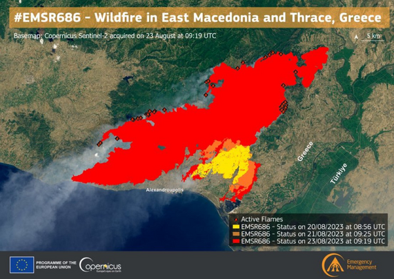
Our #RapidMappingTeam has delivered its 2⃣nd Monitoring Product for the large #wildfire burning in East Macedonia and Thrace Region
With a total burnt area of 7⃣2⃣,3⃣4⃣4⃣ ha🔥, this wildfire is the largest recorded on 🇪🇺European soil in years
🐦🔗: https://n.respublicae.eu/CopernicusEMS/status/1694643392863465488
#EMSR686 #Alexandroupolis #Greece #RapidMappingTeam #wildfire
Velocity22 🏴☠️ · @Velocity2222
1323 followers · 8236 posts · Server libretooth.gr🔥 10 ημέρες καίει η φωτιά στον Έβρο
🔥 Στη Δαδιά, 12 μήνες μετά τη Φωτιά δεν είχαν γίνει αντιπυρικές ζώνες
🔥 Ξεπέρασε σε διάρκεια και αυτή της Ρόδου
#imageoftheday
Burning for the 10th day.
The #Αλεξανδρουπολης #Alexandroupolis🇬🇷 #Wildfires continue to rage in #Greece
🔴The burnt area has reached 7⃣7⃣,0⃣0⃣0⃣ ha with 1⃣2⃣0⃣ 🔥active hot spots
The @CopernicusEMS #RapidMappingTeam is working 24/7 on mapping products
#imageoftheday #αλεξανδρουπολης #alexandroupolis #wildfires #greece #RapidMappingTeam #antireport
Velocity22 🏴☠️ · @Velocity2222
1322 followers · 8231 posts · Server libretooth.gr#EMSR686 #Alexandroupolis #Greece🇬🇷
#antireport #antireportgr
Our #RapidMappingTeam has delivered its 2⃣nd Monitoring Product for the large #wildfire burning in East Macedonia and Thrace Region
With a total burnt area of 7⃣2⃣,3⃣4⃣4⃣ ha🔥, this wildfire is the largest recorded on 🇪🇺European soil in years
@antireportgr
#emsr686 #alexandroupolis #greece #antireport #antireportgr #RapidMappingTeam #wildfire
Velocity22 🏴☠️ · @Velocity2222
1322 followers · 8231 posts · Server libretooth.gr#EMSR690
#antireport #antireportgr
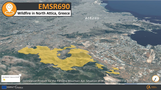
Only 12 hours after the start of the activation, our #RapidMappingTeam delivered its Delineation Product to monitor the #wildfire that is burning north of #Athens, in #Greece🇬🇷
@antireportgr
🔥A total burnt area of 3,027.6 ha has been detected using yesterday's #Sentinel2 imagery More at👇
https://storymaps.arcgis.com/stories/960b8aa46350419ab3a2767161a446b6
#emsr690 #antireport #antireportgr #RapidMappingTeam #wildfire #athens #greece #Sentinel2
Copernicus EU · @CopernicusEU
2258 followers · 9462 posts · Server respublicae.euRT Copernicus EMS
#EMSR683 #Floods in #Norway🇳🇴
Our #RapidMappingTeam has already delivered 1⃣5⃣ products but more are in the pipeline
1⃣2⃣ new Delineation Products are planned to be delivered using today's VHR satellite🛰️ imagery
Updates coming 🔜
More at👇
https://rapidmapping.emergency.copernicus.eu/EMSR683/reporting
🐦🔗: https://n.respublicae.eu/CopernicusEMS/status/1691749458671755706
#EMSR683 #floods #norway #RapidMappingTeam
Copernicus EU · @CopernicusEU
2246 followers · 9452 posts · Server respublicae.euRT Copernicus EMS
#EMSR680 #Floods in #Slovenia🇸🇮
Our #RapidMappingTeam has delivered 1⃣2⃣ Products in the last few days, detecting a total of 577 ha of flooded areas🌊
🔽Example: Grading Product for the #Luče AoI, northeast of #Ljubljana
Read more about our activities👇
https://rapidmapping.emergency.copernicus.eu/EMSR680/reporting
🐦🔗: https://n.respublicae.eu/CopernicusEMS/status/1691019955787976704
#EMSR680 #floods #Slovenia #RapidMappingTeam #Luče #Ljubljana
Evropska komisija · @EKvSloveniji
40 followers · 3286 posts · Server respublicae.euRT Copernicus EMS
#EMSR680 #Floods in #Slovenia🇸🇮
Our #RapidMappingTeam has already delivered 5⃣ products but more are in the pipeline
8⃣ new products are planned to be delivered tonight using today's VHR satellite🛰️ imagery
Updates coming 🔜
More at👇
https://rapidmapping.emergency.copernicus.eu/EMSR680/reporting
🐦🔗: https://n.respublicae.eu/CopernicusEMS/status/1689553737403019265
#EMSR680 #floods #Slovenia #RapidMappingTeam
Evropska komisija · @EKvSloveniji
40 followers · 3282 posts · Server respublicae.eu🛰 Poplave v Sloveniji - @CopernicusEMS slike pomagajo 🇸🇮@URS_ZR pri delu na terenu. 💪
👇Ljubno:
🏘️ 336 prizadetih zgradb
🚗 13,8 km prizadetih cestnih povezav
#EUSolidarity #EUCivilProtectionMechanism
<div class="rsshub-quote">
Copernicus EMS: #EMSR680 #Floods in #Slovenia🇸🇮
Our #RapidMappingTeam has delivered its Grading Product for the #Ljubno AoI, northeast of #Ljubljana, using #VHR🛰️ imagery acquired on 10 August, detecting:
🔸3⃣3⃣6⃣ affected buildings🏘️
🔸13.8km of affected roads🚗
🔗https://rapidmapping.emergency.copernicus.eu/EMSR680/reporting
</div>
🐦🔗: https://n.respublicae.eu/EKvSloveniji/status/1689948421266788352
#EUsolidarity #EUCivilProtectionMechanism #EMSR680 #floods #Slovenia #RapidMappingTeam #Ljubno #Ljubljana #VHR
Evropska komisija · @EKvSloveniji
40 followers · 3267 posts · Server respublicae.euRT Copernicus EMS
#EMSR680 #Floods in #Slovenia🇸🇮
Our #RapidMappingTeam has been requested to provide Grading Products for 5⃣ new Areas of Interest
▶️AoI05 Solcava
▶️AoI06 Luce
▶️AoI07 Ljubno
▶️AoI08 Recica ob Savinji
▶️AoI09 Gornji Grad
Updates coming soon
🔗https://rapidmapping.emergency.copernicus.eu/EMSR680/reporting
🐦🔗: https://n.respublicae.eu/CopernicusEMS/status/1688870388703318017
#EMSR680 #floods #Slovenia #RapidMappingTeam
Copernicus EU · @CopernicusEU
2217 followers · 9396 posts · Server respublicae.euRT Copernicus EMS
#EMSR681 #IRCasteloBranco #Portugal 🇵🇹
Our #RapidMappingTeam has delivered its first Delineation Product using VHR satellite🛰️ imagery, detecting 6⃣,5⃣1⃣7⃣ ha of burnt area🔥
A Delineation Monitoring Product is planned for tonight
🔗https://rapidmapping.emergency.copernicus.eu/EMSR681/reporting
🐦🔗: https://n.respublicae.eu/CopernicusEMS/status/1688535301352747009
#EMSR681 #IRCasteloBranco #Portugal #RapidMappingTeam
Comissió Europea 🇪🇺 · @ComissioEuropea
12 followers · 1352 posts · Server respublicae.euRT Copernicus EMS
#EMSR682 #IFPortbou
Our #RapidMappingTeam has delivered its Grading Product for the #wildfire that broke out in Portbou in northeast #Catalunya, in #Spain🇪🇸
➡️A total burnt area of 495.5 ha has been detected🔥
➡️1.3 km of railway was also affected
🔗https://rapidmapping.emergency.copernicus.eu/EMSR682/reporting
🐦🔗: https://n.respublicae.eu/CopernicusEMS/status/1688488372354883584
#EMSR682 #IFPortbou #RapidMappingTeam #wildfire #Catalunya #Spain
Comissão Europeia em Portugal · @CE_PTrep
11 followers · 2213 posts · Server respublicae.euRT Copernicus EMS
#EMSR681 #IRCasteloBranco
On 4 August a #wildfire🔥 broke out west of #CasteloBranco in the Centro region, #Portugal 🇵🇹
Our #RapidMappingTeam has been activated to monitor the consequences of the wildfire
➡️A Delineation Product is planned for today
🔗https://rapidmapping.emergency.copernicus.eu/EMSR681/reporting
🐦🔗: https://n.respublicae.eu/CopernicusEMS/status/1688100516620808192
#EMSR681 #IRCasteloBranco #wildfire #CasteloBranco #Portugal #RapidMappingTeam
Copernicus EU · @CopernicusEU
2218 followers · 9395 posts · Server respublicae.euRT Copernicus EMS
#EMSR682 #IFPortbou
On 4 August a #wildfire🔥 broke out in Port Bou in northeast #Catalunya
Our #RapidMappingTeam has been activated to monitor its consequences
➡️A Delineation Product is planned for today
🔗https://rapidmapping.emergency.copernicus.eu/EMSR682/reporting
⬇️#Sentinel2 🇪🇺🛰 image of 5 Aug.
🐦🔗: https://n.respublicae.eu/CopernicusEMS/status/1688104452878733312
#EMSR682 #IFPortbou #wildfire #Catalunya #RapidMappingTeam #Sentinel2
Evropska komisija · @EKvSloveniji
40 followers · 3257 posts · Server respublicae.eu⛈️ @CopernicusEMS #RapidMappingTeam s pomočjo 🛰️v živo spremlja poplave v 🇸🇮🌊 👇
#Emsr680
<div class="rsshub-quote">
Copernicus EMS: #EMSR680 #Floods in #Slovenia🇸🇮
Heavy rain⛈️ is affecting several areas of the country causing flooding episodes and landslides
Our #RapidMappingTeam has been activated to monitor the consequences of the floods🌊
More at👇
https://rapidmapping.emergency.copernicus.eu/EMSR680/
</div>
🐦🔗: https://n.respublicae.eu/EKvSloveniji/status/1687494082623377409
#RapidMappingTeam #EMSR680 #floods #Slovenia
🇪🇺 DG DEFIS #StrongerTogether · @defis_eu
146 followers · 4654 posts · Server respublicae.euRT Copernicus EMS
#EMSR680 #Floods in #Slovenia🇸🇮
Heavy rain⛈️ is affecting several areas of the country causing flooding episodes and landslides
Our #RapidMappingTeam has been activated to monitor the consequences of the floods🌊
More at👇
https://rapidmapping.emergency.copernicus.eu/EMSR680/
🐦🔗: https://n.respublicae.eu/CopernicusEMS/status/1687490929169473541
#EMSR680 #floods #Slovenia #RapidMappingTeam
EU_ScienceHub · @EU_ScienceHub
675 followers · 2361 posts · Server respublicae.eu🔥 How can science help when disaster strikes?
We have been actively involved during the #wildfires in the Mediterranean through @CopernicusEMS, which is
➡️ monitoring the blazes
️➡️ assessing their damage & extent
➡️ supporting firefighting efforts
https://europa.eu/!bWFC8g
<div class="rsshub-quote">
Planetek Hellas: LIVE from our offices in Athens, serving our 24/7 shift as @CopernicusEMS #RapidMappingTeam, in support of the actions taken by the @GSCP_GR & Local Authorities in #Corfu for the #EMSR677 CEMS activation by @defis_eu
All the maps of the activation here https://lnkd.in/dwwaWRQ7
</div>
🐦🔗: https://n.respublicae.eu/EU_ScienceHub/status/1685190420618424320
#wildfires #RapidMappingTeam #corfu #EMSR677
Copernicus EU · @CopernicusEU
2177 followers · 9337 posts · Server respublicae.euRT Copernicus EMS
🔴#EMSR675 #Greece🇬🇷 #Ροδοςπυρκαγια
Our #RapidMappingTeam delivered an updated Monitoring Product for the wildfire in #Rhodes #Ροδος using 🛰️ imagery of 25 July at 8:48 UTC
🔥A total burnt area of 1⃣5⃣,1⃣1⃣9⃣ ha has been detected (+1,807 ha in 24h🟢)
🔗https://rapidmapping.emergency.copernicus.eu/EMSR675/reporting
🐦🔗: https://n.respublicae.eu/CopernicusEMS/status/1684103835357175808
#EMSR675 #Greece #Ροδοςπυρκαγια #RapidMappingTeam #Rhodes #Ροδος
Copernicus EU · @CopernicusEU
2177 followers · 9336 posts · Server respublicae.euRT Copernicus EMS
#EMSR676
Our #RapidMappingTeam delivered its Grading Product for the #Aigio AoI, in northern #Peloponnese, #Greece🇬🇷
➡️A total burnt area of 1,721 ha🔥 (mostly shrub) has been detected in the satellite🛰️ imagery
➡️83 buildings affected🏚️
More at👇 https://rapidmapping.emergency.copernicus.eu/EMSR676/reporting
🐦🔗: https://n.respublicae.eu/CopernicusEMS/status/1684110744902680576
#EMSR676 #RapidMappingTeam #Aigio #Peloponnese #Greece


