
Brett Hoover · @bretthoover
165 followers · 53 posts · Server fediscience.orgQuestion for the #GIS #satellite #RemoteSensing #Geography crowd: If I wanted to find a burn area on a roughly 0.25 - 0.5 mi stretch of land over CONUS, what product (if any) would be appropriate? LandSat-9 burned area product? Or something else?
#geography #RemoteSensing #satellite #gis

Franz Kanngießer · @franz
94 followers · 21 posts · Server fediscience.orgSubmitting my manuscript on #RemoteSensing of dust storms in North Africa is a very satisfying way to start into the weekend. (On Monday afternoon, I will present some results at the EUMETSAT Meteorological Satellite Conference 2023 in Malmö.) #EMSC2023
The Big Data Cluster · @cznbigdata
235 followers · 802 posts · Server fediscience.org
Outtakes from recent work with #midjourney crafting #SciComm illustrations. #AIart
Prompts:
1- #ScienceFiction painting. The current state of observational capabilities including #InSitu, ground-based and satellite #RemoteSensing observations, in Northern Africa, the Middle East and Europe
2- #temperature predominantly drives daily DO dynamics
3- #temperature predominantly drives daily DO #dynamics
4- #TraceMetal analysis. Scientific illustration. Watercolor.
#tracemetal #dynamics #temperature #RemoteSensing #insitu #sciencefiction #aiart #scicomm #Midjourney

PatrickMeyfroidt · @pmeyfroidt
391 followers · 956 posts · Server fediscience.orghttps://mapstodon.space/@philrufin/110972285086730989
From
@philrufin
#EarthObservation mission impossible?
Need access to pan-sharpened SPOT 6/7 data across large regions in Sub-Saharan #Africa. Context is land systems / #sustainability #science, strictly non-profit, so budget is limited (surprise!). Any hint to hidden archives, institutional databases, research programs, funding lines, or else is valuable!
#esa #LadiesofLandsat #RemoteSensing #EOChat #science #sustainability #africa #earthobservation
Pierre de Buyl · @pdebuyl
72 followers · 49 posts · Server fediscience.orgThe Remote Sensing from Space team at the Royal Meteorological Institute of Belgium is is hiring a project scientist! Tasks: development of processing/analysis/operation for the GERB project https://gerb.oma.be and scientific computing. #Climate #RemoteSensing
CC
@eumetsat @simon_sat
https://www.meteo.be/fr/infos/actualite/scientific-assistant-for-the-gerb-remote-sensing-team
Ruth Mottram · @Ruth_Mottram
7005 followers · 10125 posts · Server fediscience.org
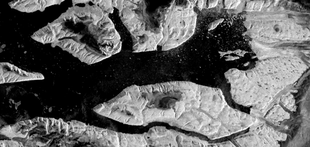
Man the #Sentinel1 images of NW #Greenland look *cool*
(Sentinel 1 is an #ESA radar satellite - so it can see through clouds, but the images are in black and white)
#SciArt #EarthArt #EO #ESAClimate #EarthObservation #SatPic #Satellite #RemoteSensing
#RemoteSensing #satellite #satpic #earthobservation #esaclimate #eo #earthart #sciart #esa #Greenland #Sentinel1
Ruth Mottram · @Ruth_Mottram
6972 followers · 10066 posts · Server fediscience.orgQuick reminder, our group @dmidk in the national centre for climate research are hiring. A broad range of scientist and climate advisory roles available in fields covering #Africa #climateServices #RemoteSensing by #RadioOccultation and for #SeaIce
Check them out:
#climatejobs #fedijobs #seaice #radiooccultation #RemoteSensing #climateservices #africa

Copernicus EU · @CopernicusEU
2177 followers · 9336 posts · Server respublicae.eu
RT Pierre Markuse
🟠 Fires🔥 on Corfu, #Greece🇬🇷 - 25 July 2023 #Copernicus🇪🇺 #Sentinel-2🛰️ Full-size ▶️ https://flic.kr/p/2oRPiHy + https://flic.kr/p/2oRLkQG #RemoteSensing #OpenData #SciComm #fire #wildfire #Greecewildfires #Corfu #corfufire Images are about 25 kilometers wide
🐦🔗: https://n.respublicae.eu/Pierre_Markuse/status/1684136395181268994
#Greece #Copernicus #Sentinel #RemoteSensing #opendata #scicomm #fire #wildfire #greecewildfires #corfu #corfufire

Santiago Gassó · @SanGasso
340 followers · 229 posts · Server airpollution.science
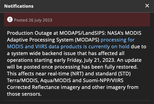
Hey those #remotesensing #EO #scientists out there
if you are user of NASA's Worldview https://worldview.earthdata.nasa.gov , it is currently not displaying MODIS and VIIRS images because a major hardware failure and they are working to bring it back online. It may take a few days.
Other imagery such as GOES and Level 2 data is still available.
#RemoteSensing #eo #scientists

Saberioon · @saberioon
2 followers · 7 posts · Server fediscience.org
We have compared the performance of Simple U-Net, Residual Attention U-Net, and Vgg16-U-Net for Inventory Inland Water Bodies based on Sentinel-2 data, and we found Vgg16-U-Net has better results in comparison to others; you can read our preprint here: https://dx.doi.org/10.2139/ssrn.4505885 #RemoteSensing #deepleaning
Saberioon · @saberioon
1 followers · 4 posts · Server fediscience.orgWe @GFZ have released Initial Sample of HYPERNETS Hyperspectral Surface Reflectance Measurements for Satellite Validation from the agricultural land at Demmin, Germany. You can download them from here : https://doi.org/10.5281/zenodo.8048348 #CalVal #remoteSensing

Niklas Jordan 🌳 🌋 🌍 🛰 · @niklas
451 followers · 1509 posts · Server niklas.social🟠 Forest fire in #Arctic circle, Russian Federation, affected about 200-300 km2 within the last two weeks.
🛰️ #Copernicus Sentinel-2, 19-07-2023
📷 Full-size: https://www.flickr.com/photos/191444271@N08/53060661632/in/dateposted-public/
Image is about 60 kilometers wide.
#wildfire #scicomm #opendata #RemoteSensing #Copernicus #Arctic

Michael Mommert · @mommermi
16 followers · 20 posts · Server mstdn.science
We will be introducing ben-ge, a truly multimodal dataset for Earth observation, tomorrow at #IGARSS2023 , session WE2.R10.3. Swing by if you're in Pasadena or check out https://github.com/HSG-AIML/ben-ge for more information.
#EarthObservation #RemoteSensing #deeplearning #multimodal #SelfSupervisedLearning
#igarss2023 #EarthObservation #RemoteSensing #deeplearning #multimodal #SelfSupervisedLearning

Dr. Flávia de Souza Mendes · @flaviamendes
147 followers · 30 posts · Server climatejustice.social
Get Ahead of the EU Deforestation Regulation - EUDR 🌳 🛰
Join us on Thursday, July 20th at 15:00 CEST for a live 45-minute webinar featuring experts from Planet and LiveEO, to find out about the essential steps for #compliance and how Earth Observation data and AI can help you get there.
Link to register 👇 https://lnkd.in/emsrt355
#eudr #supplychain #forest #deforestation #remotesensing #earthobservation
#compliance #eudr #supplychain #forest #deforestation #RemoteSensing #earthobservation
Pierre de Buyl · @pdebuyl
62 followers · 31 posts · Server fediscience.orgSo I guess I should also post job openings on mastodon 🙂
The Remote Sensing from Space team at the Royal Meteorological Institute of Belgium is hiring a project scientist!
Tasks: remote-sensing + radiative transfer. In context of
E-CONTRAIL project https://www.econtrail.com/ : detection and climate impact of contrails.
https://meteo.be/en/info/news-resume/scientific-assistant-for-the-remote-sensing-team-for-the-e-contrail-project
#RemoteSensing #Contrail
(apply before august 27 / duration about 20 months / Uccle, Belgium)
Copernicus EU · @CopernicusEU
2070 followers · 9199 posts · Server respublicae.eu
#EarthObservation fans in Africa - this one is for you! 📢
#RemoteSensing and EO provide valuable tools to monitor droughts - but how can you use #Copernicus data to do so? 🛰️
Join tomorrow’s online training session to find out: https://uni-bonn.zoom.us/meeting/register/u5MpcOCgpjkuEtf51RWGHdpxzJR0kGjNO8W4#/registration https://t.co/KmL4kqmn7C
🐦🔗: https://n.respublicae.eu/CopernicusEU/status/1676543671468957696
#EarthObservation #RemoteSensing #Copernicus
Christophe Neff · @cneff
249 followers · 1215 posts · Server social.sciences.rethe lab where i work since 18 years is now also on mastadon
#geography #geoecology #vegetation #remotesensing
#ecology
@geography
https://mastodon.social/@KIT_IfGG_Veg/110655082836293858
#Geography #geoecology #vegetation #RemoteSensing #ecology

Dr. John Barentine FRAS · @JohnBarentine
925 followers · 633 posts · Server astrodon.social#RemoteSensing data as a catalyst of #policy change: "[S]howing images of light pollution from supplemental LED lighting sources facilitated respondents to want more regulation with state government being the desired regulator."
#RemoteSensing #policy #lightpollution #greenhouses

Jose · @jgomezdans
173 followers · 570 posts · Server fediscience.orgFrom _JenniferAdams in twitter: Interested in #Thermal #RemoteSensing and want to connect with the #community? The Special Interest Group on Thermal EO has just been set up to help us connect and communicate!!
or check out our website https://thermal-rs.earsel.org #EOChat
#EOChat #Community #RemoteSensing #thermal
Copernicus EU · @CopernicusEU
2014 followers · 9087 posts · Server respublicae.eu
RT @Pierre_Markuse: 🟠 Ongoing West Kiskatinaw River #Wildfire🔥, British Columbia, #Canada🇨🇦 - 9 June 2023 #Copernicus🇪🇺 #Sentinel-2🛰️ Full-size ▶️ https://www.flickr.com/photos/pierre_markuse/52963768788/ #RemoteSensing #OpenData #SciComm #CanadaFires #CanadaWildfires Image is about 37 kilometers wide https://t.co/qv8OH67wnJ
🐦🔗: https://n.respublicae.eu/CopernicusEU/status/1667477135861112834
#wildfire #canada #Copernicus #Sentinel #RemoteSensing #opendata #scicomm #CanadaFires #CanadaWildfires