
Element 84 · @Element84
394 followers · 42 posts · Server fosstodon.org
🚨 We're excited to announce the release of #RasterVision 0.21! 🚨
With this update, Raster Vision can now:
- Consume imagery from #STAC APIs
- Work with temporal data
- Export and use models in #ONNX format
Learn more now on our blog: https://element84.com/machine-learning/introducing-raster-vision-v0-21/ #MachineLearning
#rastervision #STAC #onnx #machinelearning
Element 84 · @Element84
386 followers · 37 posts · Server fosstodon.orgWhat are you up to September 26-28? Come join us @ our Philly HQ for the 8th #STAC Sprint!
We're already counting down the days until we can reconvene with a community of collaborators to further develop the STAC ecosystem.
Learn more & register ⬇️
https://cloudnativegeo.org/blog/2023/07/stac-sprint-8
Element 84 · @Element84
361 followers · 28 posts · Server fosstodon.org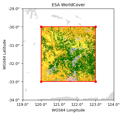
Our latest blog is for anyone hoping to create accurate raster footprints to use in their #STAC metadata.
We discuss:
- Some potential challenges folks may encounter when creating #rasterfootprints
- Options available to address those challenges
https://element84.com/blog/the-stactools-raster-footprint-utility
Element 84 · @Element84
362 followers · 23 posts · Server fosstodon.orgIf you haven't read our recent blog focused on the components of Microsoft's #PlanetaryComputer and how it connects with #STAC, what are you waiting for?
https://www.element84.com/blog/how-microsofts-planetary-computer-uses-stac
Element 84 · @Element84
355 followers · 15 posts · Server fosstodon.org
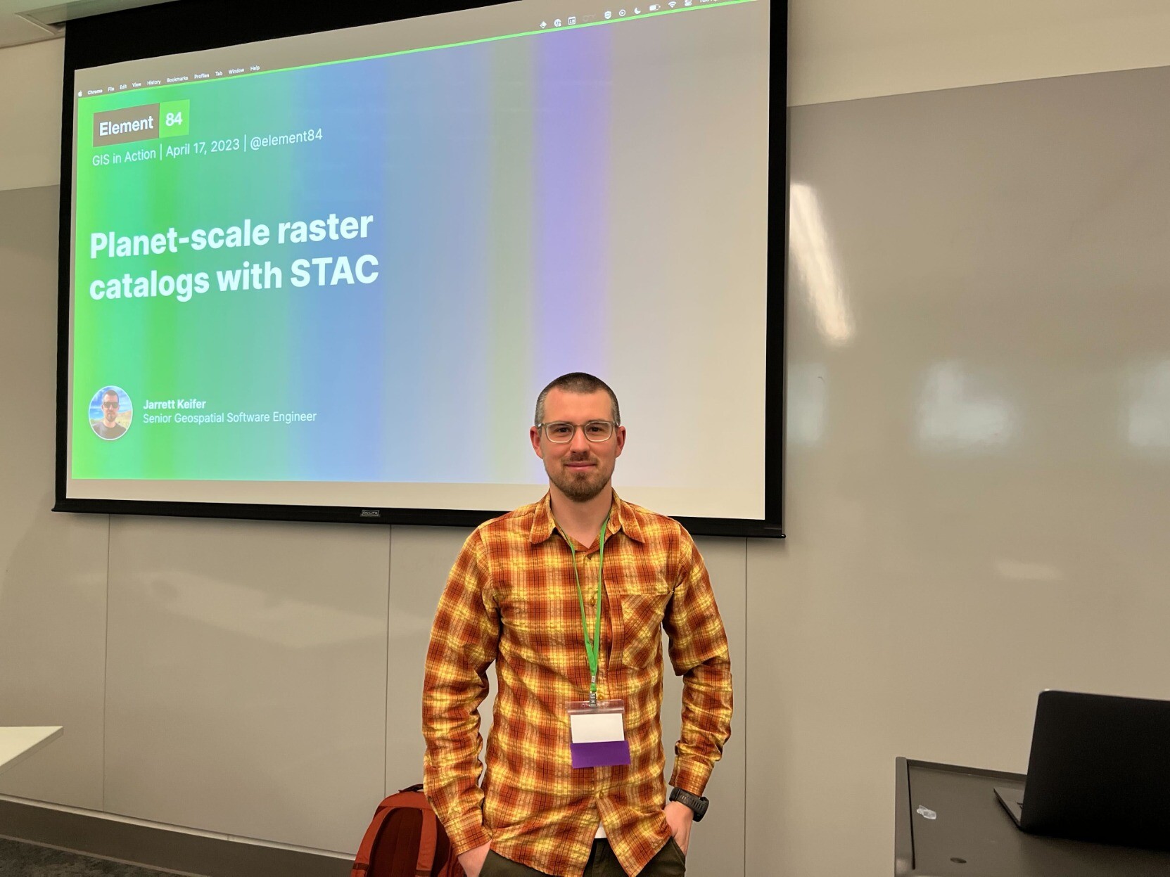
ICYMI: Earlier today Jarrett Keifer represented E84 and introduced #GISInAction attendees to #STAC!
Don't miss the rest of the GIS in Action programming; view the whole schedule here -> https://orurisa.org/GIS-in-Action-Schedule #2023GISInAction
#gisinaction #STAC #2023gisinaction

偉吉 · @weiji14
53 followers · 47 posts · Server mastodon.nz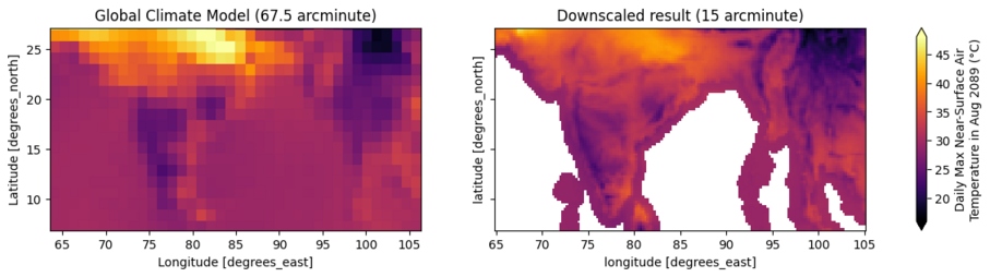
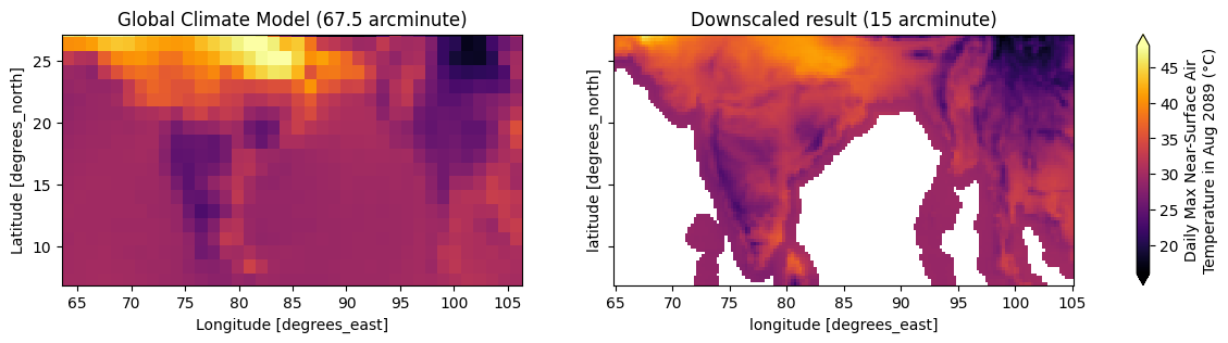
☯️ #zen3geo v0.6.0. Scale to new heights if you dare. Open 📂 STAC Assets backed by Zarr, NetCDF or CloudOptimizedGeoTIFF files using the new XpySTACAssetReader DataPipe. Attempt super-resolution 🔭 with the walkthrough on handling multi-resolution CMIP6 climate data from CarbonPlan over the Philippines 🇵🇭 at https://zen3geo.readthedocs.io/en/v0.6.0/multi-resolution.html. Clarity, seek it, give it 🥽
@zarr #STAC #NetCDF #CloudOptimizedGeoTIFF #xarray @pytorch #DataPipe #SuperResoluton #MultiResolution #CarbonPlan #CMIP6 #ClimateModel
#zen3geo #STAC #netcdf #cloudoptimizedgeotiff #xarray #DataPipe #superresoluton #multiresolution #carbonplan #cmip6 #ClimateModel
Element 84 · @Element84
348 followers · 7 posts · Server fosstodon.orgInterested in learning how #STAC
got started?
We’re launching a retrospective blog series by Matt Hanson covering the in’s & out’s of STAC history.
Check it out now: https://www.element84.com/blog/stac-a-retrospective-part-1

Sidney Schaberle Goveia · @geosapere
58 followers · 47 posts · Server mapstodon.space
Microsoft Planetary Computer
▪︎Acesso à imagens de satélite 🛰 abertas: #Landsat, #Sentinel, #MODIS, #ASTER, #ALOS (#STAC API);
▪︎Processamento distribuído ("nuvem" ☁️) usando aplicações: #Python, R #rstats, #PyTorch, #Tensorflow e #QGIS.
https://planetarycomputer.microsoft.com
#landsat #Sentinel #modis #aster #ALOS #STAC #python #RStats #pytorch #tensorflow #qgis

David Montero Loaiza · @dmlmont
72 followers · 14 posts · Server fosstodon.orgHey #RemoteSensing folks! I'm happy to announce the first release of #sen2nbar, a #Python package for converting #Sentinel2 SR to Nadir BRDF Adjusted Reflectance (#NBAR)! 🛰️😁
gh: http://github.com/ESDS-Leipzig/sen2nbar
docs: http://sen2nbar.readthedocs.io
You can use the package to convert #Sentinel2 images via:
✅ SAFE (Complete images)
✅ #stackstac (data cubes from #STAC)
✅ #cubo (mini EO data cubes)
#remotesensing #sen2nbar #python #sentinel2 #nbar #stackstac #STAC #cubo

Howard Butler · @hobu
480 followers · 30 posts · Server fosstodon.org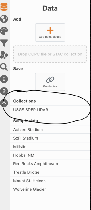
Visit http://viewer.copc.io and click the 🍔 icon and then "USGS 3DEP LiDAR" to bring in the STAC item collection and browse any of the 50 trillion points of USGS 3DEP data that's available. In your browser. #cesium #entwineio #copc #stac
#cesium #entwineio #copc #STAC

Marc Pfister · @marcpfister
18 followers · 12 posts · Server fosstodon.orgSome fantastic work building functionality on top of the Maxar Open Data collection https://github.com/giswqs/maxar-open-data
#STAC #COG
David Montero Loaiza · @dmlmont
72 followers · 14 posts · Server fosstodon.orgHey #RemoteSensing folks! I'm happy to announce the first release of #cubo, a lovely #Python package for easily creating EO mini cubes from #STAC 🛰️🧊
gh: https://github.com/davemlz/cubo
docs: https://cubo.readthedocs.io
The cool thing about #cubo is that you just need to introduce a pair of coordinates, the edge size of the cube, and the start and end dates. Then you can select the STAC collection you require (also the endpoint) and the spatial resolution!
#remotesensing #cubo #python #STAC #geospatial #geopython #dataviz #eochat #gischat
Marc Pfister · @marcpfister
15 followers · 7 posts · Server fosstodon.org#STAC for the first delivery of Maxar Open Data for #Turkey #Syria #earthquake can be viewed via https://radiantearth.github.io/stac-browser/#/external/maxar-opendata.s3.amazonaws.com/events%2FKahramanmaras-turkey-earthquake-23%2Fard%2Forder_collections%2F6115996073164321381_root_collection.json
#STAC #turkey #syria #earthquake
Marc Pfister · @marcpfister
15 followers · 4 posts · Server fosstodon.orgFirst collects for the Maxar Open Data imagery for #Turkey #Syria earthquake are now available, see https://www.maxar.com/open-data/turkey-earthquake-2023 or https://registry.opendata.aws/maxar-open-data/index.html for direct access #STAC #ARD #COG
#turkey #syria #STAC #ard #cog

Qiusheng Wu · @giswqs
172 followers · 28 posts · Server fosstodon.org#Leafmap v0.16.0 has been released. It supports searching and visualizing open #geospatial datasets interactively from public #STAC API endpoint (e.g., #AWS, #PlanetaryComputer). Search results can be returned as a GeoDataFrame, list, dict.
Notebook: https://leafmap.org/notebooks/64_stac_search
GitHub: https://github.com/giswqs/leafmap
#leafmap #geospatial #STAC #aws #PlanetaryComputer
Qiusheng Wu · @giswqs
170 followers · 26 posts · Server fosstodon.orgSearching and visualizing #PlanetaryComputer #geospatial datasets interactively with #leafmap. Image footprints with attribute data can be added to the map automatically and accessed through a GeoPandas GeoDataFrame
https://github.com/giswqs/leafmap/pull/347
#dataviz #geopython #opensource #stac
#PlanetaryComputer #geospatial #leafmap #dataviz #geopython #opensource #STAC
Qiusheng Wu · @giswqs
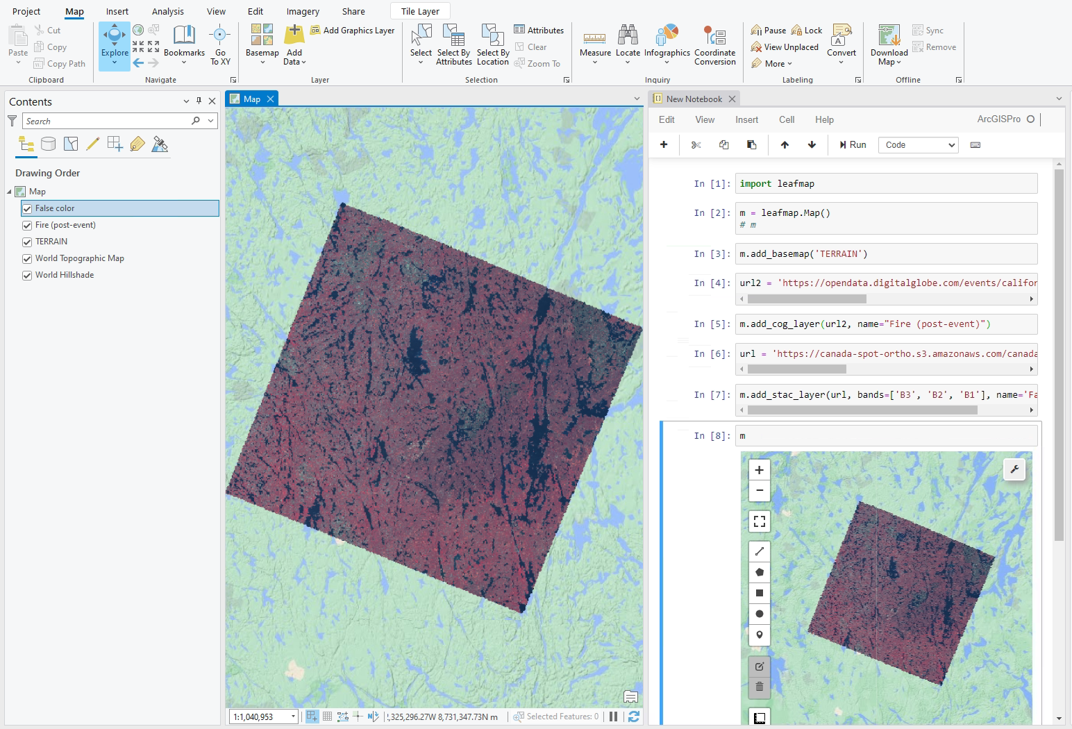
110 followers · 11 posts · Server fosstodon.org
#Leafmap now supports #ArcGIS Pro. Visualizing #COG #STAC in ArcGIS with one line of code.
Notebook: https://github.com/giswqs/leafmap/blob/master/examples/notebooks/63_arcgis.ipynb
Video: https://youtu.be/kWdL06Bc2VQ
#leafmap #arcgis #cog #STAC #geospatial #dataviz #arcgispro #gischat
伟吉 · @weiji14
20 followers · 18 posts · Server mastodon.nz
Slides for my ☯️ #zen3geo #Pangeo #ML talk on 🌏 #geospatial data pipelines are at https://hackmd.io/@weiji14/2022zen3geo. 📽️ Video will come once I get the recording!
- Walkthrough: https://zen3geo.readthedocs.io/en/v0.5.0/walkthrough.html
- Install: https://anaconda.org/conda-forge/zen3geo
- Discuss: https://github.com/weiji14/zen3geo/discussions
#gischat #DataScience #MachineLearning #STAC #CloudNativeGeoSpatial #EarthObservation #torchData #DataPipe #xarray #Python #FOSS #ML4EO
#zen3geo #pangeo #ml #geospatial #gischat #datascience #machinelearning #STAC #CloudNativeGeoSpatial #EarthObservation #torchdata #DataPipe #xarray #python #FOSS #ML4EO

Darren Wiens · @dkwiens
247 followers · 41 posts · Server fosstodon.orgAn older project, processing and storing spatial video (#fmv) in a standardized (#STAC metadata) way.
Blog post: https://sparkgeo.com/blog/foss-fmv-ftw-a-free-open-source-full-motion-video-workflow/
Metadata extension: https://github.com/stac-extensions/video

Niklas Jordan 🌳 🌋 🌍 🛰 · @niklas
114 followers · 1344 posts · Server niklas.socialRT @dkwiens@twitter.com
Learning lots about #STAC the last few days at #FOSS4G2021. Is there an appetite for a Jupyter-based search UI?