Dominique Derauw · @dderauw
33 followers · 27 posts · Server social.linux.pizza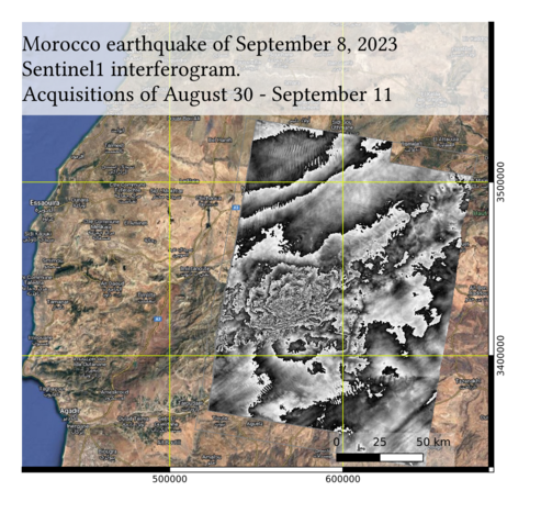
#ESA #Copernicus #Sentinel1 #InSAR interferogram of the postseismic displacements induced by the September 8 #Earthquake that occurred in #Morrocco between #Marakech and #Agadir.
If considering that movement is purely vertical and counting approx 5 fringes to the epicentre, it means a cumulated 15cm vertical displacement.
Processing made from #Sentinel1 SAR pair acquired on August 30 and September 11, 2023.
#MasTerEngine
#esa #copernicus #Sentinel1 #InSAR #earthquake #morrocco #marakech #agadir #MasTerEngine
Polar Remote Sensing, Bremen · @PolarBremen
40 followers · 15 posts · Server mas.to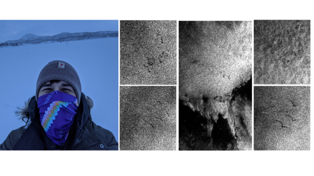
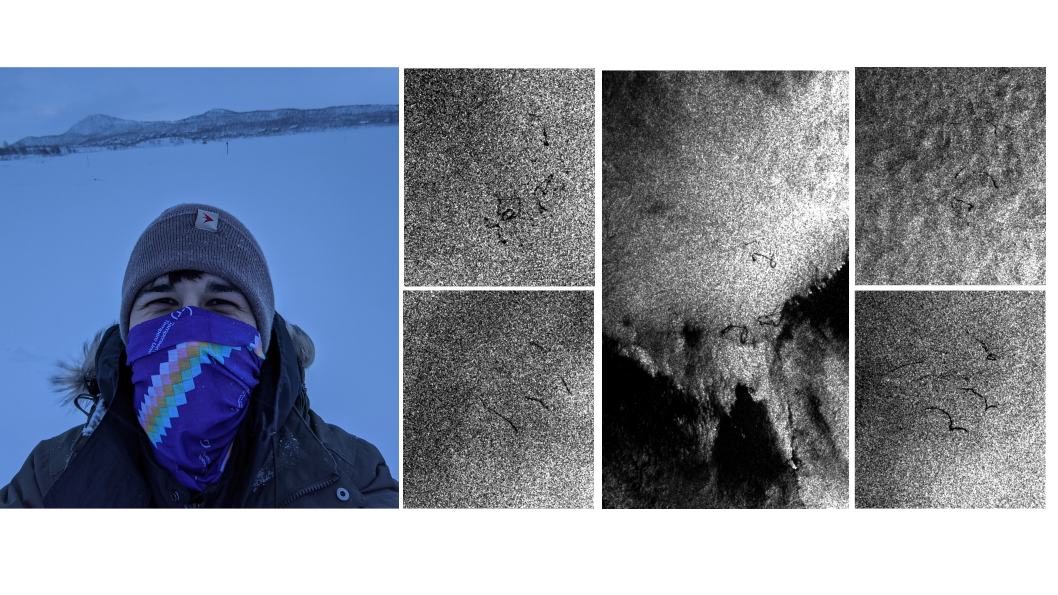
Introducing Maxi, a space sciences 🪐 master's student and our newest member! Currently exploring #Sentinel1 data to study oil seeps in the Arctic 🛰️ 🛢️ ❄️ Using #machinelearning in 🐍 to classify oilspills in #seaice conditions. In early stages, focused on data preprocessing. 🌊
#seaice #machinelearning #Sentinel1

HagollEO · @ohagolle
233 followers · 69 posts · Server fediscience.org
Les centres de traitement de données de #Télédétection de #THEIA vont bientôt disposer de capacités de traitement accrues, notamment avec #Sentinel1 et #Sentinel2.
https://labo.obs-mip.fr/multitemp/hesperides-le-jardin-des-donnees/
Nous pourrons mettre en service de nouvelles chaines de traitement ou ajouter des zones à traiter.
Le projet THEIA ouvre donc un appel à projet continu, dépouillé 4 fois par an, à destination des organismes publics Français. Première relève le 15 septembre 2023.
#Sentinel2 #Sentinel1 #theia #teledetection

EU Environment · @EU_ENV
872 followers · 3711 posts · Server respublicae.eu
RT 🇪🇺 DG DEFIS #StrongerTogether
#ImagesOfTheWeek
The beginning of August has been marked by numerous emergencies across Europe
#Copernicus is part of the 🇪🇺 response to the
↙️#Wildfires crisis in #Portugal 🇵🇹 (#Sentinel2 🇪🇺🛰️image)
↘️ Floods in #Slovenia 🇸🇮 (#Sentinel1 🇪🇺🛰️image)
#RescEU
🐦🔗: https://n.respublicae.eu/defis_eu/status/1689921691080704000
#StrongerTogether #ImagesOfTheWeek #Copernicus #wildfires #Portugal #Sentinel2 #Slovenia #Sentinel1 #rescEU

Copernicus EU · @CopernicusEU
2233 followers · 9429 posts · Server respublicae.eu
#Copernicus costs ~2 € per 🇪🇺 citizen per year
and as a result, the #EU owns 5 #Sentinel families of satellites orbiting the Earth which deliver valuable #OpenData 🌍
🛰️ #Sentinel1
🛰️ #Sentinel2
🛰️ #Sentinel3
🛰️ #Sentinel5P
🛰️ #Sentinel6
🐦🔗: https://n.respublicae.eu/CopernicusEU/status/1689219858255233024
#Copernicus #EU #Sentinel #opendata #Sentinel1 #Sentinel2 #Sentinel3 #Sentinel5P #Sentinel6

Evropska komisija · @EKvSloveniji
40 followers · 3274 posts · Server respublicae.eu
📡Ekipam @URS_ZR na terenu pomaga tudi @CopernicusEMS s satelitskimi posnetki poplavljenih območij in plazov. 👇
#EUCivilProtectionMechanism
<div class="rsshub-quote">
Copernicus EU: #ImageOfTheDay
#Slovenia is struggling with worst-ever floods on record
➡️The #EUCivilProtection Mechanism has been activated
➡️@CopernicusEMS is supporting with its #OpenData maps
⬇️The flooded areas south of Maribor are visible in this #Sentinel1 🇪🇺🛰️ radar image of 5 August
</div>
🐦🔗: https://n.respublicae.eu/EKvSloveniji/status/1688510314684317696
#EUCivilProtectionMechanism #ImageOfTheDay #Slovenia #EUcivilprotection #opendata #Sentinel1

Niklas Nienaß · @nnienass
36 followers · 903 posts · Server respublicae.eu
Hier sehen wir das Ausmaß der schlimmsten, jemals aufgezeichneten Flut in #Slowenien.
Durch die @COPERNICUS #Daten von #EMS können wir die Katastrophe erkennen und feststellen, wo Notfallmaßnahmen und gezielte Evakuierungs- und Rettungseinsätze erforderlich sind. (1/2)
<div class="rsshub-quote">
Copernicus EU: #ImageOfTheDay
#Slovenia is struggling with worst-ever floods on record
➡️The #EUCivilProtection Mechanism has been activated
➡️@CopernicusEMS is supporting with its #OpenData maps
⬇️The flooded areas south of Maribor are visible in this #Sentinel1 🇪🇺🛰️ radar image of 5 August
</div>
🐦🔗: https://n.respublicae.eu/nnienass/status/1688560989879357440
#Slowenien #daten #Ems #ImageOfTheDay #Slovenia #EUcivilprotection #opendata #Sentinel1
Dominique Derauw · @dderauw
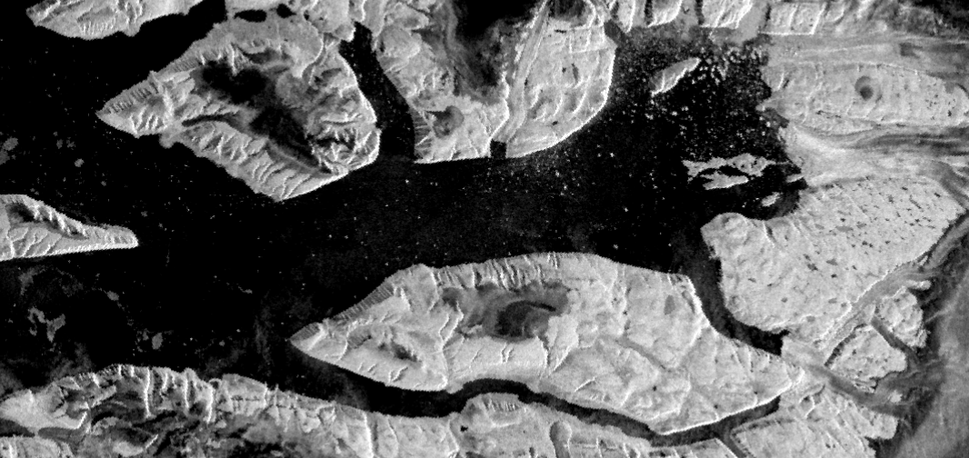
33 followers · 27 posts · Server social.linux.pizzaDo you remember the Brunt iceshelf that broke out in January 2023?
I checked where this 1500 km2 iceberg is for now.
I used #Copernicus #Sentinel1 images to follow it on its journey.
The last image on which it is visible is dated April 13. No other orbital track allow to observe it anymore with Sentinel1.
So, I checked for #SAOCOM data and found two additional images acquired in May 5 an 21.
But since then, it seems that A81 iceberg is out of sight from any #SAR satellite.
So... Good by A81
#copernicus #Sentinel1 #saocom #sar
Ruth Mottram · @Ruth_Mottram
7005 followers · 10125 posts · Server fediscience.org
Man the #Sentinel1 images of NW #Greenland look *cool*
(Sentinel 1 is an #ESA radar satellite - so it can see through clouds, but the images are in black and white)
#SciArt #EarthArt #EO #ESAClimate #EarthObservation #SatPic #Satellite #RemoteSensing
#RemoteSensing #satellite #satpic #earthobservation #esaclimate #eo #earthart #sciart #esa #Greenland #Sentinel1
Olivier Hagolle · @ohagolle
216 followers · 48 posts · Server fediscience.org
Le CNES prepare un nouveau centre de producion pour le compte du pole Theia avec une capacité de production decuplée, et de nouvelles lignes de produits basées sur #Sentinel1 et #Sentinel2.
Ce nouveau centre s'appelle Hesperides et entrera en phase operationnelle dans moins d'un an. https://labo.obs-mip.fr/multitemp/hesperides-the-data-garden/
Copernicus EU · @CopernicusEU
2034 followers · 9176 posts · Server respublicae.euRT 🛰🗺🌋❄️🌪🌊🔥👀
🇺🇳#Antartica
#A81 #iceberg back drift…
📸🛰#Sentinel1 2023.06.27 / 30
Footage: @CopernicusEU @HubSentinel https://n.respublicae.eu/ar_etsch/status/1674904812981239809 https://t.co/C3cuzdYS1S
<div class="rsshub-quote">
🛰🗺🌋❄️🌪🌊🔥👀: 🇺🇳#Antartica
#A81 #iceberg & the #Filchner Ice Shelf
📸🛰#Sentinel1 2023.06.30 & 3D in EO-Browser
Footage: @CopernicusEU @HubSentinel https://t.co/MB2gqCK6UJ
</div>
🐦🔗: https://n.respublicae.eu/ar_etsch/status/1675043068276252672
#Antartica #A81 #iceberg #Sentinel1 #Filchner

European Investment Bank · @EIB
161 followers · 2406 posts · Server respublicae.eu
RT Copernicus EU
Happy #AsteroidDay ☄️
DYK❓ The Earth is full of craters generated by asteroid impacts millions of years ago
One of the largest is Manicouagan Lake🇨🇦 which was formed 210+ million years ago & is 75 km in diameter
Radar data from #Sentinel1🇪🇺🛰️shows the crater on 26 June https://t.co/ik08WEOyot
🐦🔗: https://n.respublicae.eu/CopernicusEU/status/1674677379917127680

EuropeesParlementNL · @Europarl_NL
127 followers · 1231 posts · Server respublicae.eu
RT 🇪🇺 DG DEFIS #StrongerTogether
#ImageOfTheDay
Windpark Fryslân, located in the IJsselmeer Lake in the Netherlands 🇳🇱, is the world's largest offshore wind farm ever built in a body of fresh water
🌬️It supports the energy needs ⚡️of 500,000 households
⬇️#Sentinel1 🇪🇺🛰️ radar image of 4 June
#GlobalWindDay https://t.co/cB1ebqw66S
🐦🔗: https://n.respublicae.eu/defis_eu/status/1669249028289179649
#StrongerTogether #ImageOfTheDay #Sentinel1 #GlobalWindDay
Copernicus EU · @CopernicusEU
2014 followers · 9089 posts · Server respublicae.eu
One of @CopernicusLand's products is “Surface Soil Moisture”. It describes how wet or dry soil is in its topmost layer
We measure these values with satellite radar sensors such as the ones onboard #Sentinel1🇪🇺🛰️
⬇️ Daily surface soil moisture over Europe on 24 August 2018
🐦🔗: https://n.respublicae.eu/CopernicusEU/status/1667488807631958016
Copernicus EU · @CopernicusEU
2016 followers · 9073 posts · Server respublicae.eu
#DYK that the @CopernicusEMS Global Flood Monitoring Product is based on #Sentinel1 🇪🇺🛰️ data?
#Sentinel-1 uses #RADAR to monitor several phenomena on #OurPlanet, providing #OpenData and timely, all-weather, and day/night information to users worldwide
🐦🔗: https://n.respublicae.eu/CopernicusEU/status/1667121057981952003
#DYK #Sentinel1 #Sentinel #radar #OurPlanet #opendata
Copernicus EU · @CopernicusEU
2000 followers · 8972 posts · Server respublicae.eu
RT @CMEMS_EU: #GACopernicusMarine
The second session of the day provided insights on different ways to monitor #OurOcean
Our presenters explored:
🌊The importance of #Sentinel1 on wave observations
🐟How Argo is essential for observing the #Ocean's interior
🛰️#Sentinel6A data assimilation https://t.co/Ifu6HEGLpw
🐦🔗: https://n.respublicae.eu/CopernicusEU/status/1666036452637962240
#GACopernicusMarine #OurOcean #Sentinel1 #Ocean #Sentinel6A

UE in Italia · @europainitalia
24 followers · 1852 posts · Server respublicae.eu
.@CopernicusEU continua a monitorare le alluvioni in #EmiliaRomagna.
Ieri, 22 maggio, il radar di #Sentinel1 ha acquisito questa immagine.
Le aree alluvionate, una settimana dopo l'inizio delle piogge torrenziali del 16 maggio, sono visualizzate in rosso
RT @CopernicusEU: Copernicus for #flood monitoring
Yesterday, 22 May, the radar of our #Sentinel1🇪🇺🛰️ acquired this image over #EmiliaRomagna, in #Italy🇮🇹
Flooded areas, one week after the start of the torrent…
🐦🔗: https://n.respublicae.eu/europainitalia/status/1660935690568253443
#EmiliaRomagna #Sentinel1 #Flood #Italy
Copernicus EU · @CopernicusEU
1898 followers · 8783 posts · Server respublicae.eu
Copernicus for #flood monitoring
Yesterday, 22 May, the radar of our #Sentinel1🇪🇺🛰️ acquired this image over #EmiliaRomagna, in #Italy🇮🇹
Flooded areas, one week after the start of the torrential rains on 16 May, are visualised in red tones
🐦🔗: https://n.respublicae.eu/CopernicusEU/status/1660931524978409473
#Flood #Sentinel1 #EmiliaRomagna #Italy

EU EnvironmentAgency · @euenvironment
362 followers · 690 posts · Server respublicae.eu
RT @CopernicusEU: Copernicus for #flood monitoring
Yesterday, 22 May, the radar of our #Sentinel1🇪🇺🛰️ acquired this image over #EmiliaRomagna, in #Italy🇮🇹
Flooded areas, one week after the start of the torrential rains on 16 May, are visualised in red tones https://t.co/x3YS5ZOhCD
🐦🔗: https://n.respublicae.eu/EUEnvironment/status/1660959281510772739
#Flood #Sentinel1 #EmiliaRomagna #Italy
Copernicus EU · @CopernicusEU
1889 followers · 8724 posts · Server respublicae.eu
RT @CopernicusEU: On 23 January, an iceberg 5 times the size of Malta calved in #Antarctica🇦🇶
#Copernicus #Sentinel1🇪🇺🛰️ captured #A81 on 16 May after it travelled around 400 km across the #WeddellSea
The iceberg is now only 1.3 km away from the Filchner-Ronne Ice Shelf https://t.co/rBLqlOL9Aq
🐦🔗: https://n.respublicae.eu/CopernicusEU/status/1658848765992742916
#Antarctica #Copernicus #Sentinel1 #A81 #WeddellSea