
Chuixiang (Tree) Yi · @TreeYi
9 followers · 3835 posts · Server mastodon.world
RT @Wisconet
We're going to be doing our best to get weather stations spread across the state of Wisconsin, but you can help meteorologists, farmers, and your fellow Wisconsinites by joining @CoCoRaHS and collecting precipitation measurements every day! #WIwx https://twitter.com/NWSOwlieSkywarn/status/1648062022137925636

Drought Center · @droughtcenter
76 followers · 62 posts · Server mastodon.world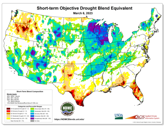
Another significant #winter #storm brought heavy snow to the #Midwest this past week, leaving the region extremely/exceptionally wet on the latest short-term #drought blends. On the other end of the spectrum, long-term dry conditions (of the extreme and exceptional variety) continue to plague the #GreatPlains and much of #Oregon.
Learn more at http://ndmcblends.unl.edu.
#winter #storm #Midwest #drought #GreatPlains #oregon #weather #climate #droughtmonitoring #orwx #mnwx #WIwx

Bob SomeAle · @bob_some_ale
144 followers · 229 posts · Server mastodon.world

Duncan da Husky · @duncandahusky
569 followers · 5349 posts · Server redwombat.social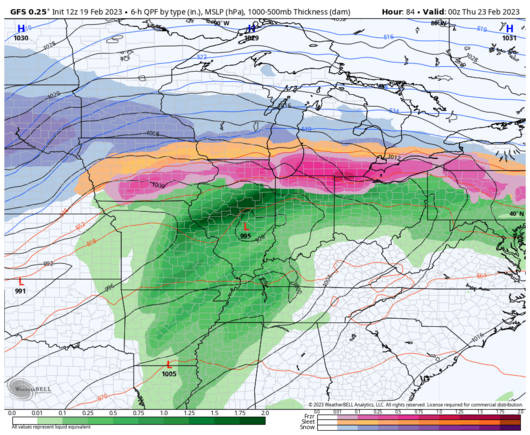
Well, this looks all kinds of fun this week.
https://twitter.com/TDSwx/status/1627381812396716032
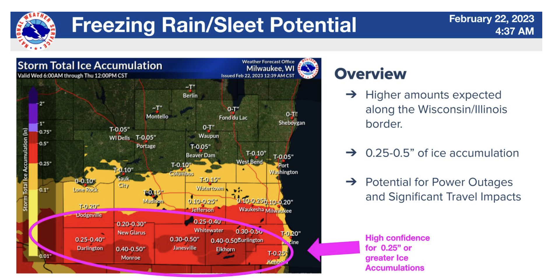
“While heavy snow is poss this week for the Upper Midwest, the poss of ice is also a concern. Models continue to suggest a freezing rain threat into portions of the northern OH Valley & southern Great Lakes Wed- Thu. We will continue to monitor this week! #ILwx #INwx #MIwx #WIwx”

Andrea Singletary · @BlingSing
25 followers · 9 posts · Server mastodon.worldJust saw on the Bird App that the folks at the NWS MKE/Sullivan office are planning to sleep there for the next several days to ride out this winter storm. Take from that what you will. #wiwx
Andrea Singletary · @BlingSing
29 followers · 32 posts · Server mastodon.worldJust saw on the Bird App that the folks at the NWS MKE/Sullivan office are planning to sleep there for the next several days to ride out this winter storm. Take from that what you will. #wiwx
Andrea Singletary · @BlingSing
25 followers · 6 posts · Server mastodon.worldNothing is falling from the sky yet. Excuse me, I was promised a blizzard? #WIwx
Andrea Singletary · @BlingSing
29 followers · 32 posts · Server mastodon.worldNothing is falling from the sky yet. Excuse me, I was promised a blizzard? #WIwx

Addie Chernow 🏳️⚧️ · @addie
37 followers · 498 posts · Server houseofcreativeweirdos.com
Ugh
RT @NWSTwinCities@twitter.com
This leaf says it all, we have officially reached 31.4° at the office.
It's been 154 days since we were last below 32° in Chanhassen (April 27, 2022). Today also marks the first time since 2014 in which we've seen a September freeze!
🐦🔗: https://twitter.com/NWSTwinCities/status/1575078509344886784
Addie Chernow 🏳️⚧️ · @addie
37 followers · 498 posts · Server houseofcreativeweirdos.comhttps://twitter.com/nwsduluth/status/1574811020974911497 https://t.co/LyxQlbklPS
RT @NWSduluth@twitter.com
We have confirmed that there were on and off snow showers falling this morning along the Gunflint Trail in Cook County! Nothing accumulated, but signs of things to come? 😉#mnwx #wiwx #winter
🐦🔗: https://twitter.com/NWSduluth/status/1574811020974911497
Addie Chernow 🏳️⚧️ · @addie
37 followers · 498 posts · Server houseofcreativeweirdos.com
WHAT DOES IT MEAN?!!?
RT @WxBrendan@twitter.com
DOUBLE RAINBOW 🌈 -- Amazing sight following that quick storm over Dane County. Our thanks to Dennis for sending this photo our way! #wiwx
🐦🔗: https://twitter.com/WxBrendan/status/1530985134488420354
Addie Chernow 🏳️⚧️ · @addie
37 followers · 498 posts · Server houseofcreativeweirdos.com
RT @MikeAugustyniak@twitter.com
I'd call our next 6 days of weather better but not great. Lots of clouds, 1/2"–2" of rain likely, and temps. that will still run below our normal highs in the low 60s. Join @WCCOShayla@twitter.com and me for the forecast; at noon on @WCCO@twitter.com, or streaming all day on @CBSNews@twitter.com #MNwx #WIwx
🐦🔗: https://twitter.com/MikeAugustyniak/status/1519347353672638465
Addie Chernow 🏳️⚧️ · @addie
37 followers · 498 posts · Server houseofcreativeweirdos.com
Tomorrow and Saturday are Next Alert days — stay with our @WCCO@twitter.com Next Weather team to keep you informed this weekend.
RT @NWSTwinCities@twitter.com
The afternoon update on the Day 2 SPC outlook for Friday showed a decrease in category for most of the area, with our best severe weather risk confined to far southwestern MN. The outlook for Saturday did not change compared to the previous update. #mnwx #wiwx
🐦🔗: https://twitter.com/NWSTwinCities/status/1517283851004907520
Addie Chernow 🏳️⚧️ · @addie
37 followers · 498 posts · Server houseofcreativeweirdos.com
RT @NWSTwinCities@twitter.com
Rain and snow will move into the area by this afternoon. Some minor snow accumulations are possible, but not expecting much to stick around as we head into Monday. We dry out briefly ahead of another system Tuesday-Thursday. #mnwx #wiwx
🐦🔗: https://twitter.com/NWSTwinCities/status/1510559769601318916
Addie Chernow 🏳️⚧️ · @addie
37 followers · 498 posts · Server houseofcreativeweirdos.com
RT @MikeAugustyniak@twitter.com
One storm controlled our weather all last week, and 1 storm will control our weather this coming week. Between, this wknd, we'll catch (and see) our breath 🌬 Wind chills the next 2 mornings will be more typical of February, with sunny & cold aft'ns. See you 8a @WCCO@twitter.com #MNwx #WIwx
🐦🔗: https://twitter.com/MikeAugustyniak/status/1507663931350863872
Duncan da Husky · @duncandahusky
206 followers · 4331 posts · Server redwombat.social
I shiver in antici…
RT @TDSwx@twitter.com
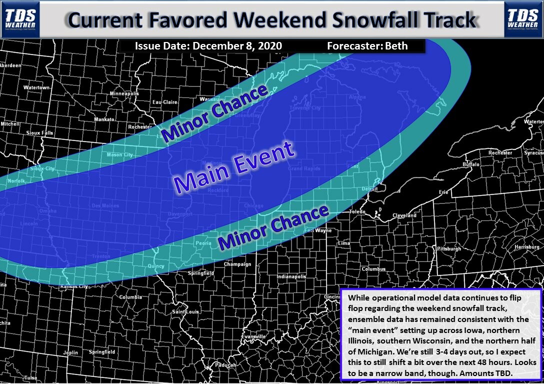
A lot of chatter out there regarding the late week/weekend *potential* snow storm. The favored track is currently across Iowa, N Illinois, S Wisconsin, and the northern half of Michigan. It's likely to be a narrow band of snow. Amounts TBD. #INwx #ILwx #MIwx #WIwx #IAwx #snow
#inwx #ilwx #miwx #WIwx #IAwx #snow
Duncan da Husky · @duncandahusky
206 followers · 4331 posts · Server redwombat.social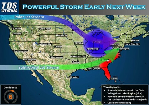
I am inordinately excited about this prospect! (Working from home probably helps, though...)
RT @B_Carp01@twitter.com
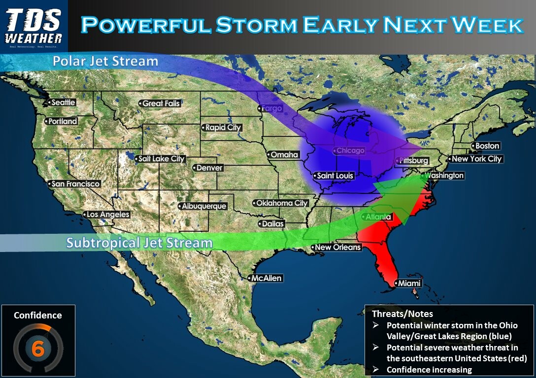
A powerful storm will develop early next week as the Polar & Subtropical Jet Streams come together. This significantly increases the threat for a winter storm in the Great Lakes/Ohio Valley, along w/ severe weather southeast! #INwx #ILwx #OHwx #MIwx #WIwx #FLwx #GAwx #SCwx #NCwx
#inwx #ilwx #OHwx #miwx #WIwx #flwx #GAwx #SCwx #NCwx
Duncan da Husky · @duncandahusky
206 followers · 4331 posts · Server redwombat.social
Duncan da Husky · @duncandahusky
206 followers · 4331 posts · Server redwombat.social
The next two weeks are forecasted to be cooler than normal, and that makes me so happy! I am SO DONE with summer.
RT @TDSwx@twitter.com
6 out of the last 7 Septembers have featured well above normal temps in the Midwest. The first *half* of September looks to feature widespread below normal temps, with today's European data trending even cooler. Out of the recent norm! #INwx #ILwx #OHwx #MIwx #WIwx #AGwx #Energy
#inwx #ilwx #OHwx #miwx #WIwx #AGwx #energy
Duncan da Husky · @duncandahusky
206 followers · 4331 posts · Server redwombat.social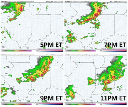
RT @TDSwx@twitter.com
Quick four-panel of the MCS/possible #derecho progression between 5pm-11pm this evening. Strongest winds will be across N IL and NW IN, where widespread gusts of 80-100mph are likely. System will gradually weaken over IN as it moves SE. #ILwx #INwx #MIwx #WIwx #AGwx
#derecho #ilwx #inwx #miwx #WIwx #AGwx