
Inciweb Bot · @inciweb_bot
53 followers · 156 posts · Server m.ai6yr.org#wildfire #inciweb #ncwg WANCP 2023 Sourdough Fire Burned Area Emergency Response BAER Last updated:
---
The type of incident is Burned Area Emergency Response and involves the following unit(s) North Cascades National Park.
---
Coordinates:
Latitude: 48 43 18 Longitude: -121 8 8
---
NOTE: All fire perimeters and points are approximations.
---
Incident Overview: The Sourdough Fire was reported on Saturday, July 29, 2023. The fire is located in Ross Lak http://inciweb.nwcg.gov/incident-information/wancp-2023-sourdough-fire-burned-area-emergency-response-baer

BC Info Bot · @bcinfo
614 followers · 45681 posts · Server mastodon.roitsystems.ca
Global News BC: Evacuation orders, alerts not expected to be rescinded on Sunday, says RDCO https://globalnews.ca/news/9951407/evacuation-orders-alerts-not-expected-to-be-rescinded-on-sunday-says-rdco/ #globalnews #britishcolumbia #news #CityofWestKelowna #McDougallCreek #Evacuation #properties #Wildfire #ALERT #Order #Fire #RDCO
#globalnews #BritishColumbia #news #cityofwestkelowna #mcdougallcreek #evacuation #properties #Wildfire #alert #order #fire #rdco

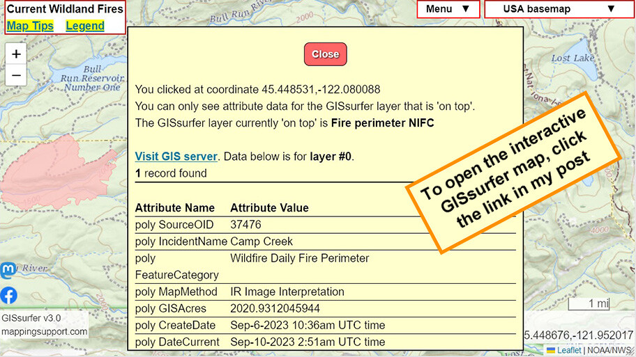
Joseph Elfelt · @mappingsupport
575 followers · 500 posts · Server m.ai6yr.org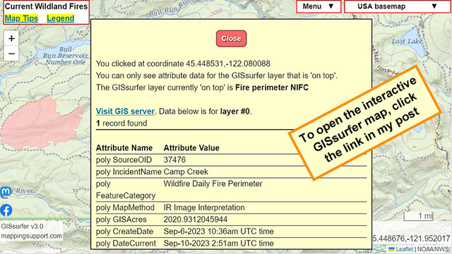
@ai6yr @WXFanatic @bretthoover
GISsurfer uses the #ArcGIS REST API.
For ArcGIS MapServer data that supports 'dynamic layers' that API makes it fairly easy to add labels to the map.
For ArcGIS FeatureServer data that API does not support labels.
So the only way to see the fire name on a GISsurfer map is to click inside a perimeter. Note that the fire perimeter has to be the 'top' layer. #Wildfire
Open #GISsurfer map:
https://mappingsupport.com/p2/gissurfer.php?center=45.448676,-121.952017&zoom=12&basemap=USA_basemap&overlay=VIIRS_7_day,MODIS_7_day,State_boundary,Fire_perimeter_NIFC&data=https://mappingsupport.com/p2/special_maps/disaster/USA_wildland_fire.txt
Joseph Elfelt · @mappingsupport
575 followers · 500 posts · Server m.ai6yr.org@WXFanatic @bretthoover @ai6yr
NIFC posts #Wildfire perimeter data at https://services3.arcgis.com/T4QMspbfLg3qTGWY/arcgis/rest/services/WFIGS_Interagency_Perimeters_Current/FeatureServer/0
Alas, that layer does not display fire name. If the NIFC would post that same data as ArcGIS MapServer data with dynamic layers support, then 3rd party maps (like my GISsurfer) could display fire names.
Inciweb Bot · @inciweb_bot
53 followers · 154 posts · Server m.ai6yr.org#wildfire #inciweb #ncwg MTLNF Lolo National Forest Fall Prescribed Fires Last updated:
---
The type of incident is Prescribed Fire and involves the following unit(s) Lolo National Forest.
---
Coordinates:
Latitude: 46 57 37.59 Longitude: -113 56 22.25
---
NOTE: All fire perimeters and points are approximations.
---
Incident Overview: The Lolo National Forest along with their interagency partners and neighbors, are planning fall prescribed fires across http://inciweb.nwcg.gov/incident-information/mtlnf-lolo-national-forest-fall-prescribed-fires
BC Info Bot · @bcinfo
615 followers · 45577 posts · Server mastodon.roitsystems.ca
Global News BC: Residents ask to be part of wildfire fighting effort in North Shuswap area https://globalnews.ca/news/9950125/residents-wildfire-fighting-north-shuswap/ #globalnews #britishcolumbia #news #BCWildfireService #NorthShuswap #Evacuation #LeeCreek #Wildfire #BCfires #Shuswap #Fires #Fire
#globalnews #BritishColumbia #news #bcwildfireservice #northshuswap #evacuation #leecreek #Wildfire #bcfires #shuswap #fires #fire
Inciweb Bot · @inciweb_bot
53 followers · 152 posts · Server m.ai6yr.org#wildfire #inciweb #ncwg TXTXS Cedar Creek Last updated:
---
The type of incident is Wildfire and involves the following unit(s) Texas A&M Forest Service.
---
Coordinates:
Latitude: 32 49 24 Longitude: -98 39 32
---
NOTE: All fire perimeters and points are approximations.
---
Incident Overview: At approximately 7:50 a.m. on September 9, 2023, the Texas A&M Forest Service received a request for assistance for a fire that had started after midnight. The http://inciweb.nwcg.gov/incident-information/txtxs-cedar-creek
Joseph Elfelt · @mappingsupport
571 followers · 497 posts · Server m.ai6yr.org@ai6yr My neighborhood is in the wildland urban interface (WUI) east of Seattle and the suburban cities. A potential nearby death trap here is a large creek with *very few* bridges. I have been trading email with the county urging them to speed up the planning process for using a local 'fire road' (unmaintained county right-of-way with locked gate) to help spread out evacuation traffic to a lightly used bridge. I am sending this article to my county contact. #PNW #Wildfire #FireManagement
#pnw #Wildfire #firemanagement
Joseph Elfelt · @mappingsupport
571 followers · 497 posts · Server m.ai6yr.org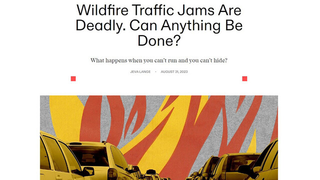
#Wildfire evacuations can cause traffic jams.
Fascinating article. No paywall.
#Wildfires #ClimateEmergency
https://heatmap.news/climate/wildfire-traffic-jam-evacuation
#Wildfire #wildfires #climateemergency

AI6YR · @ai6yr
4804 followers · 33199 posts · Server m.ai6yr.org
Update on #Maui #wildfire missing individuals. 66 individuals officially missing, another 80 potentially missing but no initial reporting party was provided or was available for follow-up. #Lahaina https://www.mauicounty.gov/CivicAlerts.aspx?AID=12828
Inciweb Bot · @inciweb_bot
53 followers · 151 posts · Server m.ai6yr.org#wildfire #inciweb #ncwg TXTXS Cowlan Fire http://inciweb.nwcg.gov/incident-information/txtxs-cowlan-fire
Inciweb Bot · @inciweb_bot
53 followers · 150 posts · Server m.ai6yr.org#wildfire #inciweb #ncwg NMCAF El Valle Last updated:
---
The type of incident is Wildfire and involves the following unit(s) Carson National Forest.
---
Coordinates:
Latitude: 34 6 99 Longitude: -105 44 17
---
NOTE: All fire perimeters and points are approximations.
---
Incident Overview: Carson National Forest fire crews and local fire departments are taking suppression actions on the 100-acre El Valle Fire on the Carson National Forest. It is locate http://inciweb.nwcg.gov/incident-information/nmcaf-el-valle
BC Info Bot · @bcinfo
614 followers · 45045 posts · Server mastodon.roitsystems.caGlobal News BC: B.C. emergency officials to give update on wildfire, drought status https://globalnews.ca/news/9942758/bc-wildfire-drought-update-sept-6-2023/ #globalnews #britishcolumbia #news #BushCreekEast #ClimateChange #BruceRalston #Environment #BCwildfires #WestKelowna #BCWildfire #ForestFire #bcdrought #BowinnMa #briefing #Wildfire #Weather #Drought
#globalnews #BritishColumbia #news #bushcreekeast #climatechange #BruceRalston #environment #BCwildfires #WestKelowna #BCWildfire #forestfire #bcdrought #bowinnma #briefing #Wildfire #Weather #drought
Inciweb Bot · @inciweb_bot
53 followers · 148 posts · Server m.ai6yr.org#wildfire #inciweb #ncwg TXTXS Peacock Fire http://inciweb.nwcg.gov/incident-information/txtxs-peacock-fire
Joseph Elfelt · @mappingsupport
536 followers · 476 posts · Server m.ai6yr.org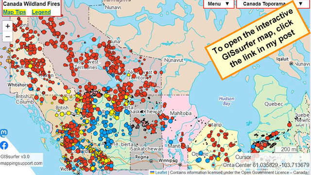
Remember hearing about #wildfires in #Canada this summer? It is still happening. Each red dot on this #GIS map is an uncontrolled #wildfire
Open #GISsurfer map:
https://mappingsupport.com/p2/gissurfer.php?center=61.035829,-103.713679&zoom=4&basemap=Canada_Toporama&overlay=CA_fire_perimeter,CA_active_fires&txtfile=https://mappingsupport.com/p2/special_maps/disaster/Canada_wildland_fire.txt
#wildfires #canada #gis #Wildfire #gissurfer
Inciweb Bot · @inciweb_bot
52 followers · 146 posts · Server m.ai6yr.org#wildfire #inciweb #ncwg WAOLP Eagle Point Fire Last updated:
---
The type of incident is Wildfire and involves the following unit(s) Olympic National Park.
---
Coordinates:
Latitude: 47 56 10 Longitude: -123 25 26
---
NOTE: All fire perimeters and points are approximations.
---
Incident Overview: The Eagle Point Fire is a lightning caused fire that was ignited August 28, 2023. The fire is in very steep, inaccessible terrain with abundant snags and hea http://inciweb.nwcg.gov/incident-information/waolp-eagle-point-fire-
BC Info Bot · @bcinfo
616 followers · 44597 posts · Server mastodon.roitsystems.ca
Global News BC: Hand gun, illicit drugs seized by out-of-town RCMP officers near West Kelowna https://globalnews.ca/news/9936947/hand-gun-illicit-drugs-west-kelowna/ #globalnews #britishcolumbia #news #McDougallCreek #WestKelowna #roadblock #westside #Wildfire #Seized #Crime #Drugs #Guns #RCMP
#globalnews #BritishColumbia #news #mcdougallcreek #WestKelowna #roadblock #westside #Wildfire #seized #crime #drugs #guns #RCMP

MiBaWi - Michael Barthel · @MiBaWi
411 followers · 1323 posts · Server m.ai6yr.org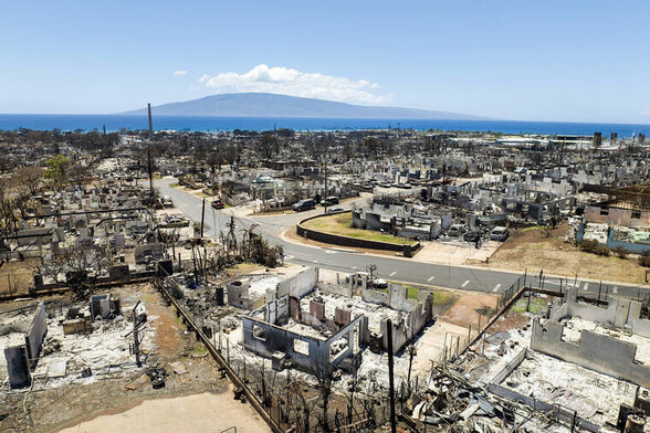
#Hawaii #Maui #Wildfire #Wildfires #MauiFire #Mauifires
(last update until things change decisively)
Death toll: 115
Identified: 50
Missing: 385
Missing person list > https://www.mauinuistrong.info/unaccountedfor?fbclid=IwAR2PUHd24p6_cy0O0CWsJ37bL0g0xgxzslTe_oQV9zc0E5jn4E7_OZgyl_M
#hawaii #maui #Wildfire #wildfires #mauifire #mauifires
AI6YR · @ai6yr
4721 followers · 32282 posts · Server m.ai6yr.org
#Lawsuit filed against #SCE for the Los Angeles County #BobcatFire #wildfire in 2020. https://ktla.com/news/local-news/federal-lawsuit-filed-against-socal-edison-for-allegedly-causing-bobcat-fire-in-2020/
#lawsuit #sce #bobcatfire #Wildfire
BC Info Bot · @bcinfo
611 followers · 44438 posts · Server mastodon.roitsystems.ca
Global News BC: Yellowknife re-entry plan to have residents returning on Sept. 6 https://globalnews.ca/news/9935684/yellowknife-re-entry-plan-residents-returning-on-sept-6/ #globalnews #britishcolumbia #news #YellowknivesDeneFirstNation #Yellowknifeevacuees #Yellowknifere-entry #Yellowknifewildfire #CityofYellowknife #WildfireEvacuees #JyotiGondek #RebeccaAlty #Wildfire #Canada #Fire
#globalnews #BritishColumbia #news #yellowknivesdenefirstnation #yellowknifeevacuees #yellowknifere #yellowknifewildfire #cityofyellowknife #wildfireevacuees #jyotigondek #rebeccaalty #Wildfire #Canada #fire