
Matthew Bandy · @inti
237 followers · 242 posts · Server archaeo.social
#archaeology #landscapes from #lidar 31
By the time of Spanish colonial arrival in #NewMexico (1590 CE) the #RioChama was mostly abandoned. The inhabitants of the large Classic period villages had moved on to other parts of the Pueblo world, in particular the Rio Grande valley and nearby areas such as the Galisteo Basin. They left behind a well-preserved landscape of villages, shrines, and fields.
Pictured are the Classic sites of Sapawe and Ponsipa'akeri.
#archaeology #landscapes #lidar #newmexico #riochama #archaeologylandscapevisualization
Matthew Bandy · @inti
216 followers · 229 posts · Server archaeo.social
#archaeology #landscapes from #lidar 30
The large Classic villages of the #RioChama were part of a larger phenomenon throughout the Pueblo world. Archaeologists refer to this period as Pueblo IV, and it was in this interval from about 1300 CE through the arrival of the Spaniards that the Pueblo societies we know today took shape in terms of settlement, religion, social structure, etc.
Pictured are the Classic sites of Tsama'ouinge and Te'ewi'ouinge.
#archaeology #landscapes #lidar #riochama #archaeologylandscapevisualization
Matthew Bandy · @inti
208 followers · 223 posts · Server archaeo.social
#archaeology #landscapes from #lidar 29
The #RioChama is a major tributary of the Rio Grande in Northern #NewMexico. Beginning around 1350 CE (the Classic Period) it experienced major population growth and saw the growth of large nucleated villages of 1000+ rooms. Much of this growth was from immigration. These villages were ancestral to the modern Tewa peoples.
The village of Poshu'ouinge is pictured.
https://en.wikipedia.org/wiki/Poshuouinge
#archaeology #landscapes #lidar #riochama #newmexico #archaeologylandscapevisualization

Matthew Bandy · @inti
200 followers · 217 posts · Server archaeo.social
#archaeology #landscapes from #lidar 28
Camp Ojo Caliente #NewMexico was established as an outpost of Fort Craig in 1859, and was quickly abandoned in 1861 at the beginning of the Civil War. It was reoccupied from 1879-1882 during the later Apache Wars. The first shots of Victorio's War were fired near here when a band of Apaches attacked the garrison and made off with their horses.
In the image, the camp is on the right and an older Pueblo is on the left.
#archaeology #landscapes #lidar #newmexico #archaeologylandscapevisualization

Matthew Bandy · @inti
198 followers · 210 posts · Server archaeo.social
#archaeology #landscapes from #lidar 27
Fort Craig #NewMexico was built in 1853 and by 1861 had become the largest fort in the Southwest, with a garrison of over 2,000. In 1862 the Confederate Army of New Mexico elected to bypass the fort on its march north to Santa Fe. Between 1863 and 1865 Fort Craig was the US Army headquarters during its prosecution of the Apache Wars. It was abandoned in 1885.
https://en.wikipedia.org/wiki/Fort_Craig
#archaeology #landscapes #lidar #newmexico #archaeologylandscapevisualization

Matthew Bandy · @inti
194 followers · 208 posts · Server archaeo.social
#archaeology #landscapes from #lidar 26
Fort Cummings, #NewMexico was established at Cooke's Pass to protect the Butterfield Overland stage route and the southern road to California. Between 1848 and 1861 the pass was dangerous for travelers, who were often ambushed and killed by the Apache. The Fort was built in 1863 near a stage stop. It was abandoned in 1873, but was sporadically used again from 1880-1886 during later conflicts with the Apache.
#archaeology #landscapes #lidar #newmexico #archaeologylandscapevisualization
Matthew Bandy · @inti
192 followers · 205 posts · Server archaeo.social
#archaeology #landscapes from #lidar 25
Fort Union, #NewMexico was built in 1851 to protect the Santa Fe Trail. The original fort (on the left in the image) was meant to provide protection from Indian raids and was built at the base of a bluff. When the Civil War broke out, it became obvious that this position was vulnerable to artillery, and the Fort was reconstructed on the open plains (right) and the star fort was constructed. It was abandoned in 1891.
#archaeology #landscapes #lidar #newmexico #archaeologylandscapevisualization
Matthew Bandy · @inti
181 followers · 201 posts · Server archaeo.social
#archaeology #landscapes from #lidar 24
Horse Camp Mill Pueblo, a large nucleated village in west-central #NewMexico. Like the nearby Techado Spring Pueblo featured yesterday, it was destroyed by violence in the early 14th century. The site seems to have been an important node in a regional road network, and was next to the Acoma Salt Trail.
https://www.archaeologysouthwest.org/pdf/arch-sw-v22-no1.pdf, pgs 10-11.
@PattMeeples I'll just keep tagging you on these Cibola sites.
#archaeology #landscapes #lidar #newmexico #archaeologylandscapevisualization
Matthew Bandy · @inti
182 followers · 196 posts · Server archaeo.social
#archaeology #landscapes from #lidar 23
This is Techado Spring Pueblo, a large nucleated village in central #NewMexico that was the site of a massacre probably in the early 14th century. Much of the pueblo is burned, and researchers found unburied human skeletal remains and evidence of violent trauma. It is possible that this reflects conflict with migrants fleeing drought further north around this time.
@PattMeeples would know more about this site.
#archaeology #landscapes #lidar #newmexico #archaeologylandscapevisualization
Matthew Bandy · @inti
179 followers · 193 posts · Server archaeo.social
#archaeology #landscapes from #lidar 22
Pueblo Blanco (aka Tabirá, aka LA 51), a large late prehistoric, early colonial period village in central #NewMexico. Note the shallow pits surrounding the village, similar to what we saw yesterday at the nearby Pueblo Colorado. Probably adobe borrow pits.
Tabirá was a Piro-speaking town, was the site of a Spanish mission, and was finally abandoned in the 1670s due to raiding by mobile Plains groups.
#archaeology #landscapes #lidar #newmexico #archaeologylandscapevisualization
Matthew Bandy · @inti
172 followers · 189 posts · Server archaeo.social
#archaeology #landscape #visualization from #lidar 21 - my 18th post on #ChacoanBeltRoads.
Here's a final example of a belt road-like feature from the very late prehistoric pueblo site of Pueblo Colorado (LA 476) in central #NewMexico. Aside from the belt road feature, there is a clear road running to the northeast. Also visible are numerous shallow pits surrounding the adobe architectural core. I interpret these as borrow pits for adobe production.
#archaeology #landscape #visualization #lidar #chacoanbeltroads #newmexico #archaeologylandscapevisualization
Matthew Bandy · @inti
172 followers · 179 posts · Server archaeo.social
#archaeology #landscape #visualization from #lidar 20 - my 17th post on #ChacoanBeltRoads.
Most known examples of belt roads in the American southwest are from the northern San Juan and seem to be associated with chacoan period sites. As noted, race tracks in other areas are linear. There are very few examples from elsewhere. Here are two from the later (post-1300 CE) sites of Tovakwa and Totaskwina in the #Jemez mountains of central #NewMexico.
#archaeology #landscape #visualization #lidar #chacoanbeltroads #jemez #newmexico #archaeologylandscapevisualization
Matthew Bandy · @inti
169 followers · 177 posts · Server archaeo.social
#archaeology #landscape #visualization from #lidar 19 - my 16th post on #ChacoanBeltRoads.
Apart from the belt roads I've show so far from #Coloado and #NewMexico, there are many in SE #Utah as well. Here is a selection.
#archaeology #landscape #visualization #lidar #chacoanbeltroads #coloado #newmexico #utah #archaeologylandscapevisualization
Matthew Bandy · @inti
161 followers · 160 posts · Server archaeo.social
#archaeology #landscape #visualization from #lidar 18 - my 15th post on #ChacoanBeltRoads.
This belt road is near the major site of Morris-41 in the La Plata valley of #NewMexico.
To me the most interesting explanation for these features is that they could represent ceremonial racetracks. Foot races were and are a part of the ritual calendar throughout the Pueblo world. Mostly, these are conducted on linear racetracks or informal courses. (see comments).
#archaeology #landscape #visualization #lidar #chacoanbeltroads #newmexico #archaeologylandscapevisualization
Matthew Bandy · @inti
157 followers · 152 posts · Server archaeo.social
#archaeology #landscape #visualization from #lidar - 17th in a series, and my 14th post on #ChacoanBeltRoads.
This belt road, like most of these features, is in SW #Colorado.
So if these features are not "roads," what are they? There seems to be a consensus that they serve some kind of "ritual" or "ceremonial" purpose. This purpose probably involved movement or travel of some kind - perhaps processions. The Nazca lines might be a decent example.
#archaeology #landscape #visualization #lidar #chacoanbeltroads #colorado #archaeologylandscapevisualization
Matthew Bandy · @inti
153 followers · 146 posts · Server archaeo.social
#archaeology #landscape #visualization from #lidar - 16th in a series, and my 13th post on #ChacoanBeltRoads.
Like the last one, this belt road is on #UteMountainUte tribal lands in #Colorado. This one is a little unusual because while it is located in the center of a large cluster of smaller sites, there is no single large site directly associated with the feature itself.
Second observation: these are probably not "roads" in any utilitarian sense.
#archaeology #landscape #visualization #lidar #chacoanbeltroads #utemountainute #colorado #archaeologylandscapevisualization
Matthew Bandy · @inti
148 followers · 137 posts · Server archaeo.social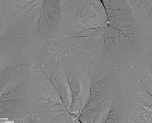
#archaeology #landscape #visualization from #lidar - 15th in a series, and my 12th post on #ChacoanBeltRoads.
This belt road is on #UteMountainUte tribal lands as as far as I know has never been documented.
We're approaching the end of this series on, so perhaps now it is time to ask the question - what are these things? The first observation we can make is that they are not pan-Chacoan. No belt roads have been found on sites in #ChacoCanyon itself
#archaeology #landscape #visualization #lidar #chacoanbeltroads #utemountainute #chacocanyon #archaeologylandscapevisualization