Jared Smith · @jaredwsmith
250 followers · 298 posts · Server mastodon.onlineJared Smith · @jaredwsmith
251 followers · 320 posts · Server mastodon.onlineJared Smith · @jaredwsmith
244 followers · 280 posts · Server mastodon.onlineChanges to GOES-16 satellite data distribution over NOAAPort/SBN today. I think I'm okay with losing true full-disk data in exchange for higher-resolution data in the Northern Hemisphere in AWIPS. https://cimss.ssec.wisc.edu/satellite-blog/archives/48952
#awips #wxmastodon #weather #weatherdata #goeseast #goes16 #goesr
#goesr #goes16 #goeseast #WeatherData #Weather #wxmastodon #awips
🇺🇸 Bewickwren 🇵🇹 · @Bewickwren
324 followers · 2408 posts · Server toot.communityAfter 1800 UTC on 01 December 2022, changes were made to Full Disk #GOES16 (GOES-East) #imagery that is broadcast via the #Satellite Broadcast Network (SBN) for #AWIPS users (see the bottom section of this TOWR-S Communications).
One change was the increase in spatial resolution of the “Clean” Infrared Window (10.3 µm) from 6 km to the native 2 km (at satellite nadir).
#goes16 #imagery #satellite #awips
Jared Smith · @jaredwsmith
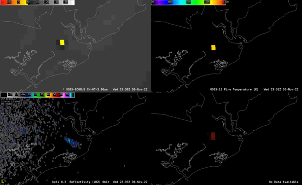
244 followers · 280 posts · Server mastodon.onlineThe fire was also hot enough for detection from the GOES-East satellite. Clockwise from top left: 3.9um shortwave infrared, Fire Temperature derived product, Fire Temp RGB, and radar reflectivity showing the smoke plume. The Fire Temp derived product detected temperatures as high as 1300°F. #wxmastodon #fire #remotesensing #goes16 #awips
#awips #goes16 #RemoteSensing #fire #wxmastodon
Jared Smith · @jaredwsmith
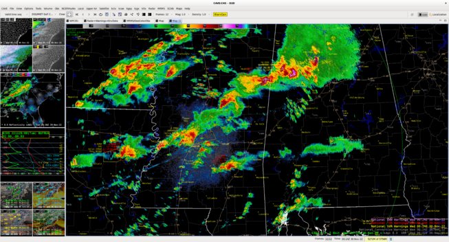
244 followers · 280 posts · Server mastodon.onlineAll is quiet in my neck of the woods, but not so much across LA, MS, and AL. Very busy radar image from KDGX (Jackson, MS) in AWIPS with numerous supercells capable of producing tornadoes this evening within a PDS Tornado Watch.
#wxmastodon #awips #alwx #mswx #lawx

