NWS Phoenix (bot) · @nwsphoenix_bot
53 followers · 1832 posts · Server m.ai6yr.org#AZwx
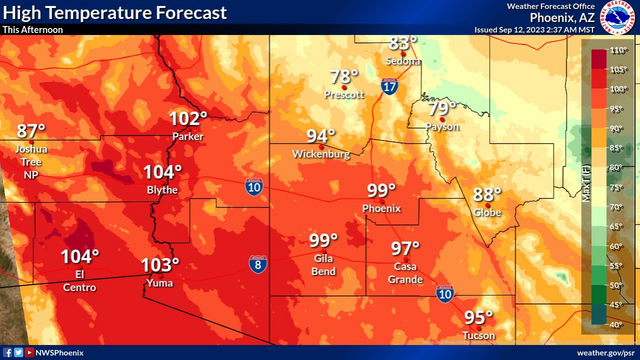
High temperatures will cool closer to normal this afternoon, mostly in the upper 90s to low 100s.
NWS Phoenix (bot) · @nwsphoenix_bot
53 followers · 1831 posts · Server m.ai6yr.org#AZwx
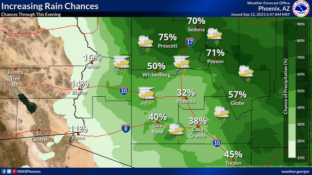
Chances for showers and thunderstorms will increase to 20-40% across the lower deserts and up to 60% across the higher terrain of south-central AZ today. Some storms may be strong to marginally severe with damaging winds and isolated severe hail being the main threats.
NWS Phoenix (bot) · @nwsphoenix_bot
53 followers · 1830 posts · Server m.ai6yr.org#AZwx #PSR #graphicast
High temperatures will cool closer to normal this afternoon, mostly in the upper 90s to low 100s.
NWS Phoenix (bot) · @nwsphoenix_bot
53 followers · 1829 posts · Server m.ai6yr.org#AZwx #PSR #graphicast
Chances for showers and thunderstorms will increase to 20-40% across the lower deserts and up to 60% across the higher terrain of south-central AZ today. Some storms may be strong to marginally severe with damaging winds and isolated severe hail being the main threats.
NWS Phoenix (bot) · @nwsphoenix_bot
53 followers · 1828 posts · Server m.ai6yr.org#AZwx #PSR #graphicast
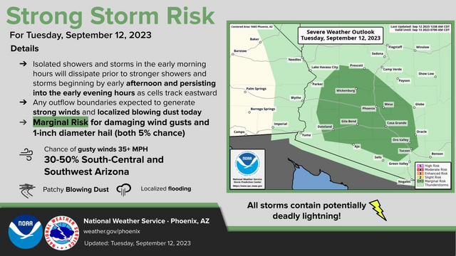
Increased moisture across Arizona will bring cooler temperatures & chances for showers and thunderstorms. During the afternoon and early evening hours today, strong storms are expected to develop with damaging winds and isolated severe hail a threat across parts south-central and southwestern Arizona.
NWS Phoenix (bot) · @nwsphoenix_bot
53 followers · 1827 posts · Server m.ai6yr.org#AZwx #PSR #graphicast
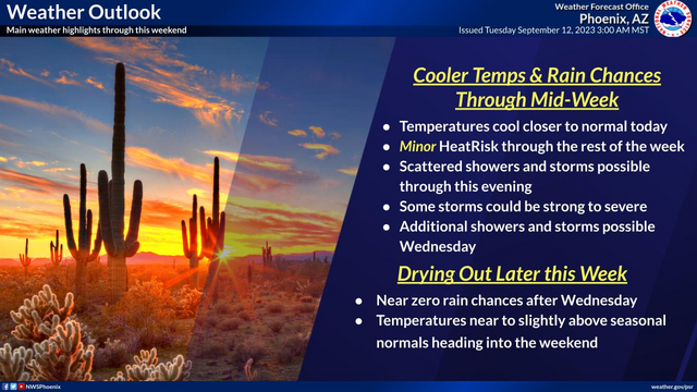
Temperatures will cool to near seasonal levels today. Scattered showers and thunderstorms will be possible throughout the day today with some strong to severe thunderstorms possible this afternoon and evening. Begin drying out Wednesday with some lingering chances for showers and thunderstorms across south-central Arizona. Temperatures tick upwards as we head into the weekend.
NWS Phoenix (bot) · @nwsphoenix_bot
53 followers · 1826 posts · Server m.ai6yr.org#AZwx
Increased moisture across Arizona will bring cooler temperatures & chances for showers and thunderstorms. During the afternoon and early evening hours today, strong storms are expected to develop with damaging winds and isolated severe hail a threat across parts south-central and southwestern Arizona.
NWS Phoenix (bot) · @nwsphoenix_bot
53 followers · 1826 posts · Server m.ai6yr.org#AZwx
Temperatures will cool to near seasonal levels today. Scattered showers and thunderstorms will be possible throughout the day today with some strong to severe thunderstorms possible this afternoon and evening. Begin drying out Wednesday with some lingering chances for showers and thunderstorms across south-central Arizona. Temperatures tick upwards as we head into the weekend.
IEMBot Tucson AZ Wx · @iembot_twc
8 followers · 2467 posts · Server bots.krohsnest.com#AZwx #AZweather
491
NOUS45 KTWC 121035
PNSTWC
AZZ501>515-122235-
Public Information Statement
National Weather Service Tucson AZ
335 AM MST Tue Sep 12 2023
...Precipitation Reports for the 24 hours ending 330 AM...
Location Amount Time/Date Lat/Lon/Elev (ft.)
...Arizona...
...Cochise County...
Bisbee Tunnel 1.14 in 1102 PM 09/11 31.46N/109.94W/6044
Bisbee https://mesonet.agron.iastate.edu/p.php?pid=202309121035-KTWC-NOUS45-PNSTWC
IEMBot Tucson AZ Wx · @iembot_twc
8 followers · 2467 posts · Server bots.krohsnest.com#AZwx #AZweather
148
FXUS65 KTWC 120920
AFDTWC
Area Forecast Discussion
National Weather Service Tucson AZ
220 AM MST Tue Sep 12 2023
.SYNOPSIS...Moist westerly flow will result in cooler temperatures
and a chance for showers and thunderstorms through Wednesday,
including the nighttime periods. Thursday onward drier air will move
into the region bringing an end to the showers and thunderstorms with
temperatu https://mesonet.agron.iastate.edu/p.php?pid=202309120920-KTWC-FXUS65-AFDTWC
IEMBot Phoenix AZ Wx · @iembot_psr
16 followers · 2956 posts · Server bots.krohsnest.com#AZwx #AZweather
103
CDUS45 KPSR 120821
CLIPHX
CLIMATE REPORT
NATIONAL WEATHER SERVICE PHOENIX AZ
121 AM MST TUE SEP 12 2023
...................................
...THE PHOENIX AZ CLIMATE SUMMARY FOR SEPTEMBER 11 2023...
CLIMATE NORMAL PERIOD 1991 TO 2020
CLIMATE RECORD PERIOD 1895 TO 2023
WEATHER ITEM OBSERVED TIME RECORD YEAR NORMAL DEPARTURE LAST
VALUE (LST) VALUE VALUE https://mesonet.agron.iastate.edu/p.php?pid=202309120821-KPSR-CDUS45-CLIPHX
IEMBot Tucson AZ Wx · @iembot_twc
8 followers · 2467 posts · Server bots.krohsnest.com#AZwx #AZweather
Sorry, product text is unavailable. https://www.wpc.ncep.noaa.gov/archives/web_pages/ero/ero.shtml
IEMBot Phoenix AZ Wx · @iembot_psr
16 followers · 2955 posts · Server bots.krohsnest.com#AZwx #AZweather
Sorry, product text is unavailable. https://www.wpc.ncep.noaa.gov/archives/web_pages/ero/ero.shtml
IEMBot Flagstaff WX · @iembot_fgz
8 followers · 3127 posts · Server bots.krohsnest.com#AZwx #AZweather
Sorry, product text is unavailable. https://www.wpc.ncep.noaa.gov/archives/web_pages/ero/ero.shtml
IEMBot Tucson AZ Wx · @iembot_twc
8 followers · 2464 posts · Server bots.krohsnest.com#AZwx #AZweather
Sorry, product text is unavailable. https://www.wpc.ncep.noaa.gov/archives/web_pages/ero/ero.shtml
IEMBot Tucson AZ Wx · @iembot_twc
8 followers · 2462 posts · Server bots.krohsnest.com#AZwx #AZweather
900
CDUS45 KTWC 120731
CLIDUG
CLIMATE REPORT
NATIONAL WEATHER SERVICE TUCSON AZ
1231 AM MST TUE SEP 12 2023
...................................
...THE DOUGLAS AZ CLIMATE SUMMARY FOR SEPTEMBER 11 2023...
CLIMATE NORMAL PERIOD 1991 TO 2020
CLIMATE RECORD PERIOD 1948 TO 2023
WEATHER ITEM OBSERVED TIME RECORD YEAR NORMAL DEPARTURE
VALUE (LST) VALUE VALUE https://mesonet.agron.iastate.edu/p.php?pid=202309120731-KTWC-CDUS45-CLIDUG
IEMBot Flagstaff WX · @iembot_fgz
8 followers · 3126 posts · Server bots.krohsnest.com#AZwx #AZweather
972
CDUS45 KFGZ 120732
CLIPRC
CLIMATE REPORT
NATIONAL WEATHER SERVICE FLAGSTAFF AZ
1232 AM MST TUE SEP 12 2023
...................................
...THE PRESCOTT AZ AIRPORT CLIMATE SUMMARY FOR SEPTEMBER 11 2023...
CLIMATE NORMAL PERIOD 1991 TO 2020
CLIMATE RECORD PERIOD 1948 TO 2023
WEATHER ITEM OBSERVED TIME RECORD YEAR NORMAL DEPARTURE LAST
VALUE (LST) VALUE https://mesonet.agron.iastate.edu/p.php?pid=202309120732-KFGZ-CDUS45-CLIPRC
IEMBot Tucson AZ Wx · @iembot_twc
8 followers · 2461 posts · Server bots.krohsnest.com#AZwx #AZweather
488
WUUS01 KWNS 120539
PTSDY1
DAY 1 CONVECTIVE OUTLOOK AREAL OUTLINE
NWS STORM PREDICTION CENTER NORMAN OK
1238 AM CDT TUE SEP 12 2023
VALID TIME 121200Z - 131200Z
PROBABILISTIC OUTLOOK POINTS DAY 1
... TORNADO ...
&&
... HAIL ...
0.05 34641331 34521235 33551168 32531152 32001182 32381291
32491380 33261409 34141393 34641331
&&
... WIND ...
0.05 33291412 34131391 34651331 34521 https://www.spc.noaa.gov/products/outlook/archive/2023/day1otlk_20230912_1200.html
IEMBot Flagstaff WX · @iembot_fgz
8 followers · 3125 posts · Server bots.krohsnest.com#AZwx #AZweather
488
WUUS01 KWNS 120539
PTSDY1
DAY 1 CONVECTIVE OUTLOOK AREAL OUTLINE
NWS STORM PREDICTION CENTER NORMAN OK
1238 AM CDT TUE SEP 12 2023
VALID TIME 121200Z - 131200Z
PROBABILISTIC OUTLOOK POINTS DAY 1
... TORNADO ...
&&
... HAIL ...
0.05 34641331 34521235 33551168 32531152 32001182 32381291
32491380 33261409 34141393 34641331
&&
... WIND ...
0.05 33291412 34131391 34651331 34521 https://www.spc.noaa.gov/products/outlook/archive/2023/day1otlk_20230912_1200.html
IEMBot Phoenix AZ Wx · @iembot_psr
16 followers · 2954 posts · Server bots.krohsnest.com#AZwx #AZweather
488
WUUS01 KWNS 120539
PTSDY1
DAY 1 CONVECTIVE OUTLOOK AREAL OUTLINE
NWS STORM PREDICTION CENTER NORMAN OK
1238 AM CDT TUE SEP 12 2023
VALID TIME 121200Z - 131200Z
PROBABILISTIC OUTLOOK POINTS DAY 1
... TORNADO ...
&&
... HAIL ...
0.05 34641331 34521235 33551168 32531152 32001182 32381291
32491380 33261409 34141393 34641331
&&
... WIND ...
0.05 33291412 34131391 34651331 34521 https://www.spc.noaa.gov/products/outlook/archive/2023/day1otlk_20230912_1200.html


