
Mapping Support · @mappingsupport
112 followers · 28 posts · Server m.ai6yr.org
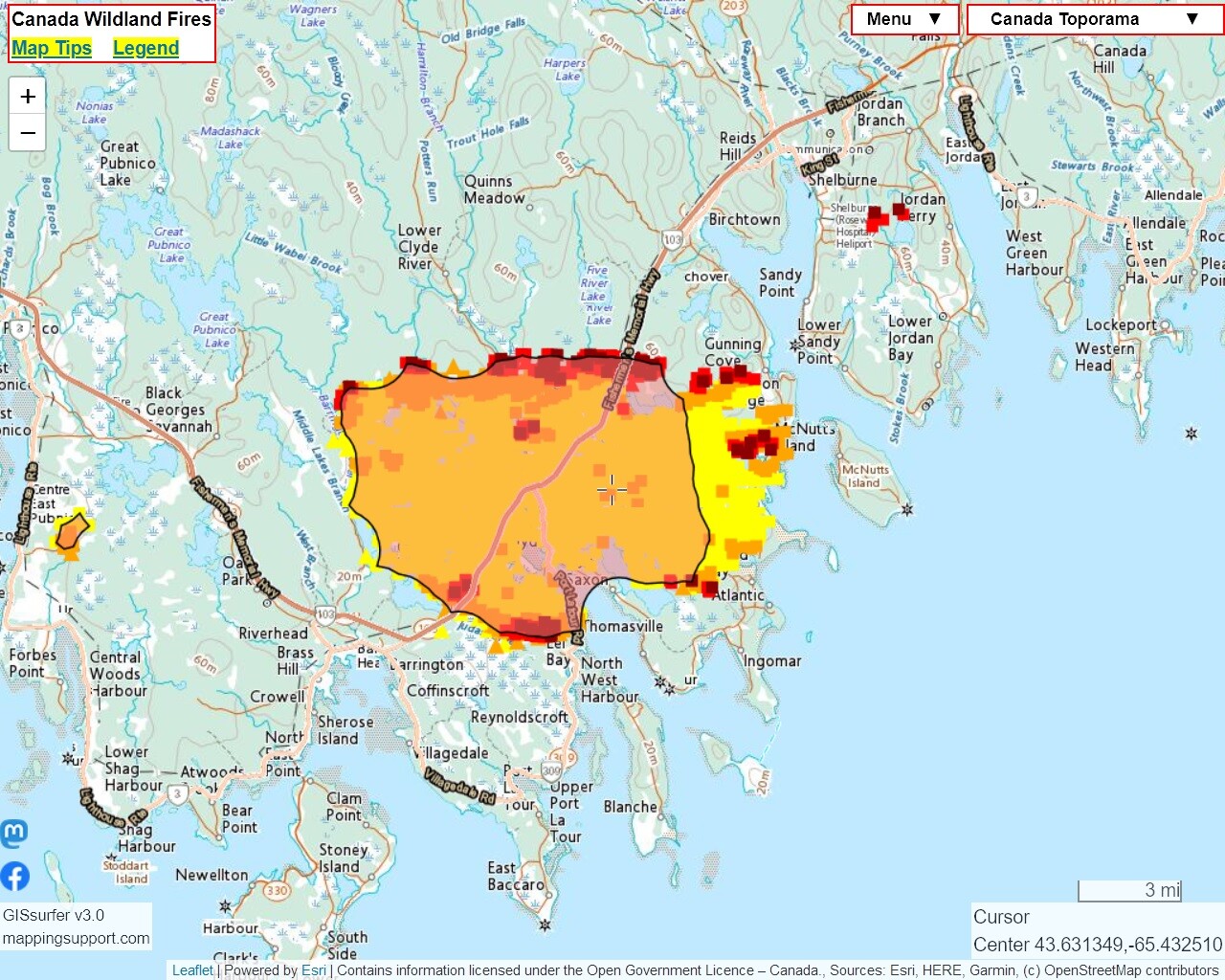
The #BarringtonLakeFire in #NovaScotia continues to burn. This MODIS/VIIRS satellite heat detection data also shows a fire has started SE of Shelburne.
Each time you open the map you will see the most recent data hosted on NASA’s server. That data is updated several times per day. #BarringtonLake #Shelburne
The 2 links in the upper left corner will help you get the most benefit from the map.
Open #GISsurfer map:
https://mappingsupport.com/p2/gissurfer.php?center=43.607062,-65.532074&zoom=11&basemap=Canada_Toporama&overlay=CA_fire_perimeter,MODIS_7_day,VIIRS_7_day,CA_M3_hotspots_last_24_hours,World_transportation&txtfile=https://mappingsupport.com/p2/special_maps/disaster/Canada_wildland_fire.txt
#barringtonlakefire #novascotia #barringtonlake #shelburne #gissurfer
Mapping Support · @mappingsupport
109 followers · 24 posts · Server m.ai6yr.org
Latest satellite heat detection data (dark red) shows #BarringtonLakeFire in #NovaScotia might be burning to water’s edge to the east in a couple of places.
#BarringtonLake #Barrington
Note also the heat detections to the west for a different fire.
If you zoom in then you can see heat detection symbols over water. Good reminder that (1) each heat detection symbol refers to an *area* and (2) sometimes the data is 'false positive'.
Open #GISsurfer map:
https://mappingsupport.com/p2/gissurfer.php?center=43.607062,-65.532074&zoom=11&basemap=Canada_Toporama&overlay=CA_fire_perimeter,MODIS_7_day,VIIRS_7_day,CA_M3_hotspots_last_24_hours,World_transportation&txtfile=https://mappingsupport.com/p2/special_maps/disaster/Canada_wildland_fire.txt
#barringtonlakefire #novascotia #barringtonlake #barrington #gissurfer
Mapping Support · @mappingsupport
104 followers · 16 posts · Server m.ai6yr.org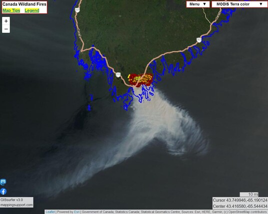
This map shows smoke pouring off the #BarringtonLakeFire in #NovaScotia. This view was captured by one of the MODIS satellites. #BarringtonLake #Barrington
Open #GISsurfer map:
https://mappingsupport.com/p2/gissurfer.php?center=43.376676,-65.618591&zoom=9&basemap=MODIS_Terra_color&overlay=CA_fire_perimeter,CA_province_boundary_blue,MODIS_7_day,VIIRS_7_day,CA_M3_hotspots_last_24_hours,World_transportation&txtfile=https://mappingsupport.com/p2/special_maps/disaster/Canada_wildland_fire.txt
#barringtonlakefire #novascotia #barringtonlake #barrington #gissurfer
Mapping Support · @mappingsupport
97 followers · 14 posts · Server m.ai6yr.org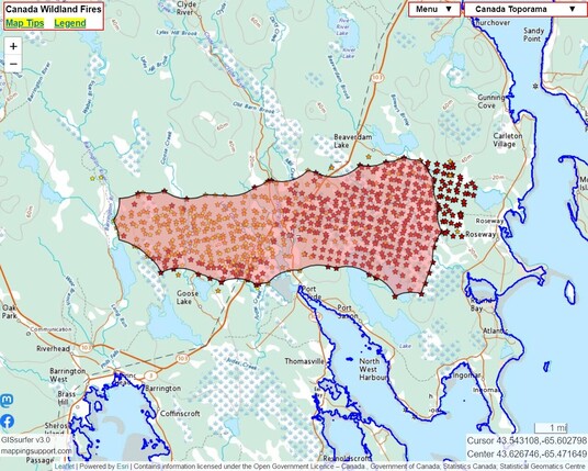
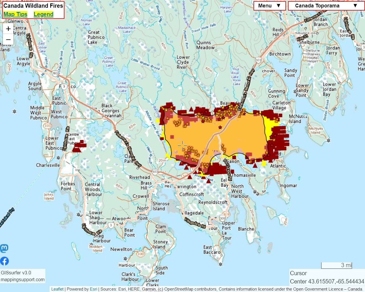
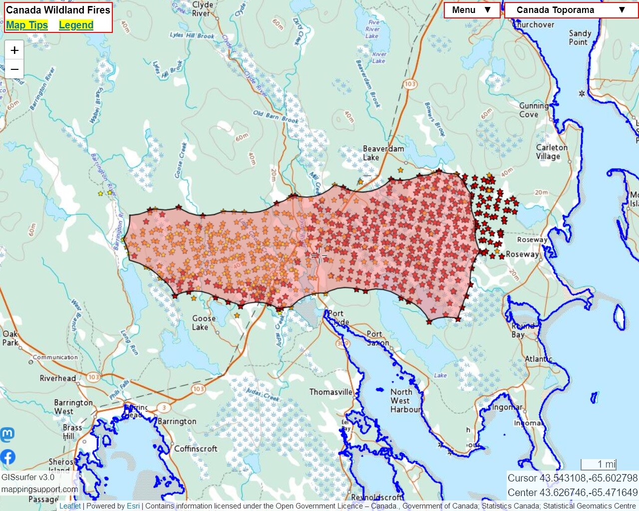
Here is a version of the Canada #wildfire map I produce that is centered at the #BarringtonLakeFire in #NovaScotia. The map displays the ‘M3’ hotspot data and perimeter.
The ‘GOES East’ basemap (zoom out) shows the wind is currently out of the north.
The map has other GIS overlay layers you can turn on including MODIS and VIIRS heat detections. For help, see the “Map tips” link in the upper left corner.
#Barrington #BarringtonLake
Open #GISsurfer map:
https://mappingsupport.com/p2/gissurfer.php?center=43.626746,-65.471649&zoom=12&basemap=Canada_Toporama&overlay=CA_M3_hotspots_last_24_hours,CA_fire_perimeter,CA_province_boundary_blue&txtfile=https://mappingsupport.com/p2/special_maps/disaster/Canada_wildland_fire.txt
#Wildfire #barringtonlakefire #novascotia #barrington #barringtonlake #gissurfer
Mapping Support · @mappingsupport
97 followers · 14 posts · Server m.ai6yr.org
Here is a version of the Canada #wildfire map I produce that is centered at the #BarringtonLakeFire in #NovaScotia.
The ‘GOES East’ basemap (zoom out) shows the wind out of the north.
The map has other GIS overlay layers you can turn on including MODIS and VIIRS heat detections. For help, see the “Map tips” link in the upper left corner.
#Barrington #BarringtonLake
Open #GISsurfer map:
https://mappingsupport.com/p2/gissurfer.php?center=43.626746,-65.471649&zoom=12&basemap=Canada_Toporama&overlay=CA_M3_hotspots_last_24_hours ,CA_fire_perimeter,CA_province_boundary_blue&txtfile=https://mappingsupport.com/p2/special_maps/disaster/Canada_wildland_fire.txt
#Wildfire #barringtonlakefire #novascotia #barrington #barringtonlake #gissurfer