
BakersRelay · @BakerRL75
673 followers · 21907 posts · Server m.ai6yr.org@nasa Promoting to #NovaScotia #HalifaxFire #ShelburneFire #BarringtonLakeFire
#novascotia #halifaxfire #shelburnefire #barringtonlakefire

Mapping Support · @mappingsupport
112 followers · 28 posts · Server m.ai6yr.org
The #BarringtonLakeFire in #NovaScotia continues to burn. This MODIS/VIIRS satellite heat detection data also shows a fire has started SE of Shelburne.
Each time you open the map you will see the most recent data hosted on NASA’s server. That data is updated several times per day. #BarringtonLake #Shelburne
The 2 links in the upper left corner will help you get the most benefit from the map.
Open #GISsurfer map:
https://mappingsupport.com/p2/gissurfer.php?center=43.607062,-65.532074&zoom=11&basemap=Canada_Toporama&overlay=CA_fire_perimeter,MODIS_7_day,VIIRS_7_day,CA_M3_hotspots_last_24_hours,World_transportation&txtfile=https://mappingsupport.com/p2/special_maps/disaster/Canada_wildland_fire.txt
#barringtonlakefire #novascotia #barringtonlake #shelburne #gissurfer
BakersRelay · @BakerRL75
672 followers · 21764 posts · Server m.ai6yr.orgFrom Los Angeles Times: “Unprecedented wildfire on Canada’s Atlantic coast still burning after four days”
#halifaxfire #barringtonlakefire #tantallonfire #novascotia

AI6YR · @ai6yr
3672 followers · 19674 posts · Server m.ai6yr.org
BakersRelay · @BakerRL75
671 followers · 21598 posts · Server m.ai6yr.orgBakersRelay signing off for the night. Be safe, be prepared, be weather aware. I’ll catch you tomorrow morning.
For those following the #HalifaxFire #TantallonFire in Nova Scotia - here are a few people to follow for information: @MiBaWi @mappingsupport @kichae @ingalls 1. Updated with hashtags: #HalifaxFire #TantallonFire #BarringtonLakeFire #ShelburneFire 2. Updated additional info source: @haligonia 3. Updated additional info source: @ai6yr 4. Updated w/website: https://www.halifax.ca/
#halifaxfire #tantallonfire #barringtonlakefire #shelburnefire
BakersRelay · @BakerRL75
671 followers · 21585 posts · Server m.ai6yr.org@zoom_earth Promoting to #BarringtonLakeFire #NovaScotia FYI @kichae @MiBaWi @ingalls
#barringtonlakefire #novascotia
Mapping Support · @mappingsupport
109 followers · 24 posts · Server m.ai6yr.org
Latest satellite heat detection data (dark red) shows #BarringtonLakeFire in #NovaScotia might be burning to water’s edge to the east in a couple of places.
#BarringtonLake #Barrington
Note also the heat detections to the west for a different fire.
If you zoom in then you can see heat detection symbols over water. Good reminder that (1) each heat detection symbol refers to an *area* and (2) sometimes the data is 'false positive'.
Open #GISsurfer map:
https://mappingsupport.com/p2/gissurfer.php?center=43.607062,-65.532074&zoom=11&basemap=Canada_Toporama&overlay=CA_fire_perimeter,MODIS_7_day,VIIRS_7_day,CA_M3_hotspots_last_24_hours,World_transportation&txtfile=https://mappingsupport.com/p2/special_maps/disaster/Canada_wildland_fire.txt
#barringtonlakefire #novascotia #barringtonlake #barrington #gissurfer
BakersRelay · @BakerRL75
671 followers · 21440 posts · Server m.ai6yr.orgFor those following the #HalifaxFire #TantallonFire in Nova Scotia - here are a few people to follow for information: @MiBaWi @mappingsupport @kichae @ingalls 1. Updated with hashtags: #HalifaxFire #TantallonFire #BarringtonLakeFire #ShelburneFire 2. Updated additional info source: @haligonia 3. Updated additional info source: @ai6yr
#halifaxfire #tantallonfire #barringtonlakefire #shelburnefire
BakersRelay · @BakerRL75
671 followers · 21426 posts · Server m.ai6yr.org
From Nova Scotia: “Update on Wildfires in Halifax Regional Municipality and Shelburne, Yarmouth Counties”
#tantallonfire #barringtonlakefire #halifaxfire #novascotia
AI6YR · @ai6yr
3668 followers · 19585 posts · Server m.ai6yr.org#BarringtonLakeFire #Halifax #NovaScotia: "Barrington Lake, Shelburne County, wildfire update:
fire is out of control, covering 10,000 hectares 50 DNRR firefighters, 40 volunteer firefighters, three DNRR helicopters and two water bombers from Newfoundland and Labrador on scene some structures have been destroyed and others are threatened, but there are no firm details on the numbers yet."
#barringtonlakefire #Halifax #novascotia
BakersRelay · @BakerRL75
672 followers · 21411 posts · Server m.ai6yr.orgFrom the Los Angeles Times: “Wildfires force thousands to flee, damage scores of homes in Canada’s Nova Scotia”
#tantallonfire #barringtonlakefire #halifaxfire #novascotia
AI6YR · @ai6yr
3669 followers · 19576 posts · Server m.ai6yr.org
#HalifaxFire: "Operational Update (10 a.m.): Halifax Regional Fire & Emergency (HRFE) crews remain on-scene and fighting the fires burning in multiple areas, with more than 788.3 hectares in the impacted area. The fire is ongoing and is not yet under control." #BarringtonLakeFire #TantallonFire #Halifax #Canada #Evacuations
#halifaxfire #barringtonlakefire #tantallonfire #Halifax #canada #evacuations
BakersRelay · @BakerRL75
672 followers · 21388 posts · Server m.ai6yr.orgBakersRelay off for the night. Be safe, be prepared, be weather aware. For those following the #HalifaxFire #TantallonFire #BarringtonLakeFire in Nova Scotia - here are a few people to follow for information: @MiBaWi @mappingsupport @kichae @ingalls 1. Updated with hashtags: #HalifaxFire #TantallonFire #BarringtonLakeFire 2. Updated additional info source: @haligonia
#halifaxfire #tantallonfire #barringtonlakefire
AI6YR · @ai6yr
3666 followers · 19543 posts · Server m.ai6yr.org
BakersRelay · @BakerRL75
672 followers · 21388 posts · Server m.ai6yr.org@pierre_markuse @wildfirescience Promoting to #BarringtonLakeFire #NovaScotia
#barringtonlakefire #novascotia
Mapping Support · @mappingsupport
104 followers · 16 posts · Server m.ai6yr.org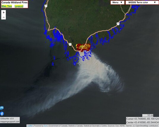
This map shows smoke pouring off the #BarringtonLakeFire in #NovaScotia. This view was captured by one of the MODIS satellites. #BarringtonLake #Barrington
Open #GISsurfer map:
https://mappingsupport.com/p2/gissurfer.php?center=43.376676,-65.618591&zoom=9&basemap=MODIS_Terra_color&overlay=CA_fire_perimeter,CA_province_boundary_blue,MODIS_7_day,VIIRS_7_day,CA_M3_hotspots_last_24_hours,World_transportation&txtfile=https://mappingsupport.com/p2/special_maps/disaster/Canada_wildland_fire.txt
#barringtonlakefire #novascotia #barringtonlake #barrington #gissurfer
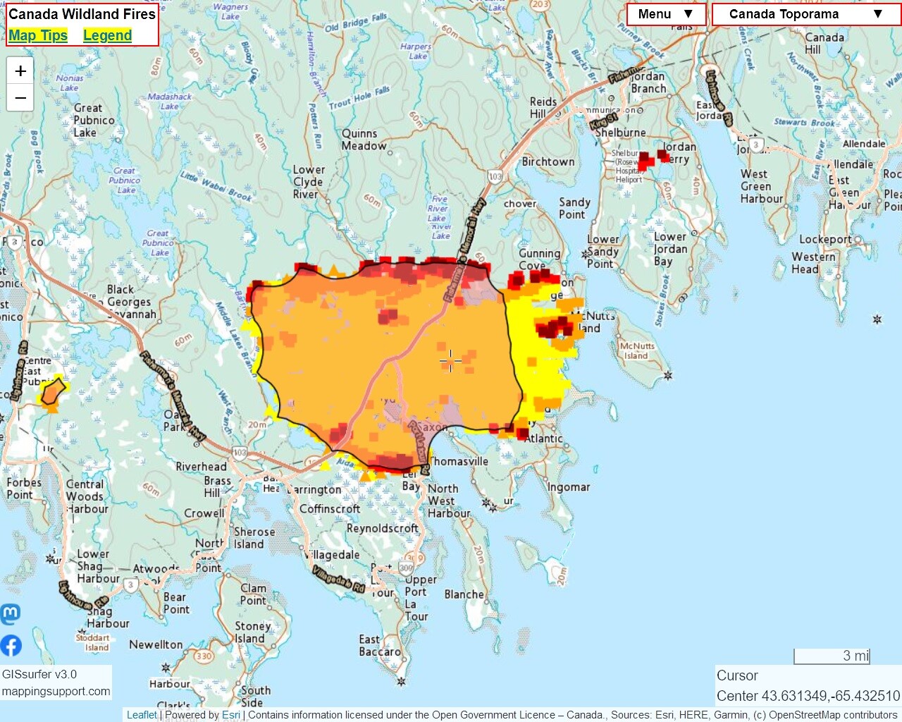
Mapping Support · @mappingsupport
100 followers · 15 posts · Server m.ai6yr.org
Tip for wildland fire maps. A uniform pattern of satellite heat detection data *might* indicate some of that data is ‘false positive’.
The screenshot below shows the #BarringtonLakeFire in #NovaScotia. Note the uniform pattern of the latest MODIS data. The “GOES East” basemap (zoom out) shows the wind is out of the north. If the fire is really ripping and the smoke has a lot of embers, that could result in ‘false positive’ hotspots downwind.
Open #GISsurfer map:
https://mappingsupport.com/p2/gissurfer.php?center=43.626746,-65.471649&zoom=12&basemap=Canada_Toporama&overlay=CA_fire_perimeter,CA_province_boundary_blue,MODIS_7_day,VIIRS_7_day,CA_M3_hotspots_last_24_hours&txtfile=https://mappingsupport.com/p2/special_maps/disaster/Canada_wildland_fire.txt
#barringtonlakefire #novascotia #gissurfer
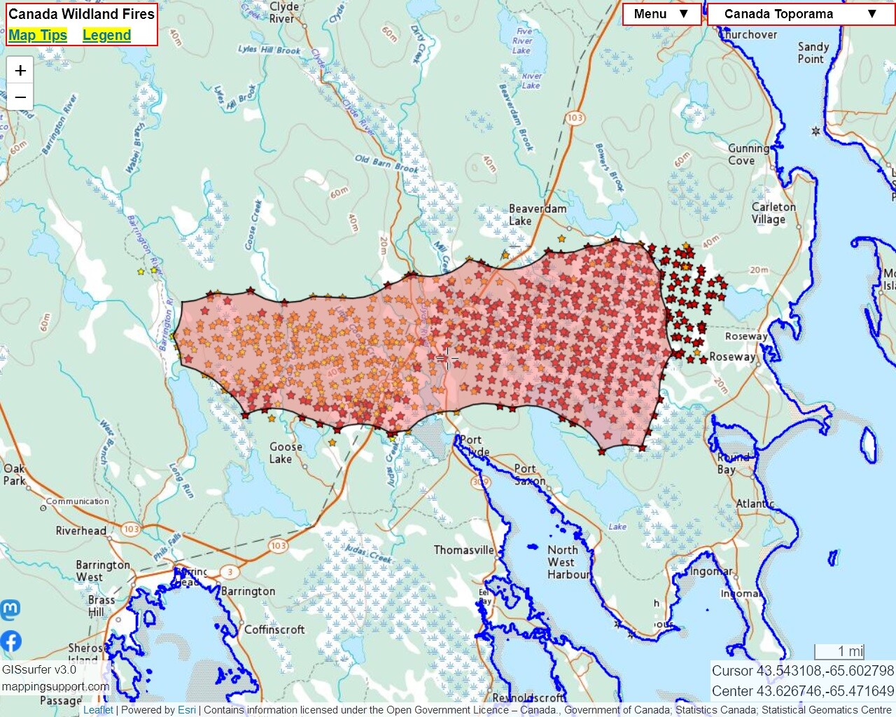
Mapping Support · @mappingsupport
97 followers · 14 posts · Server m.ai6yr.org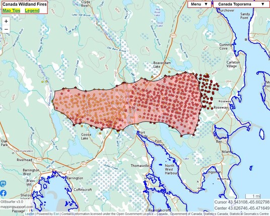
Here is a version of the Canada #wildfire map I produce that is centered at the #BarringtonLakeFire in #NovaScotia. The map displays the ‘M3’ hotspot data and perimeter.
The ‘GOES East’ basemap (zoom out) shows the wind is currently out of the north.
The map has other GIS overlay layers you can turn on including MODIS and VIIRS heat detections. For help, see the “Map tips” link in the upper left corner.
#Barrington #BarringtonLake
Open #GISsurfer map:
https://mappingsupport.com/p2/gissurfer.php?center=43.626746,-65.471649&zoom=12&basemap=Canada_Toporama&overlay=CA_M3_hotspots_last_24_hours,CA_fire_perimeter,CA_province_boundary_blue&txtfile=https://mappingsupport.com/p2/special_maps/disaster/Canada_wildland_fire.txt
#Wildfire #barringtonlakefire #novascotia #barrington #barringtonlake #gissurfer
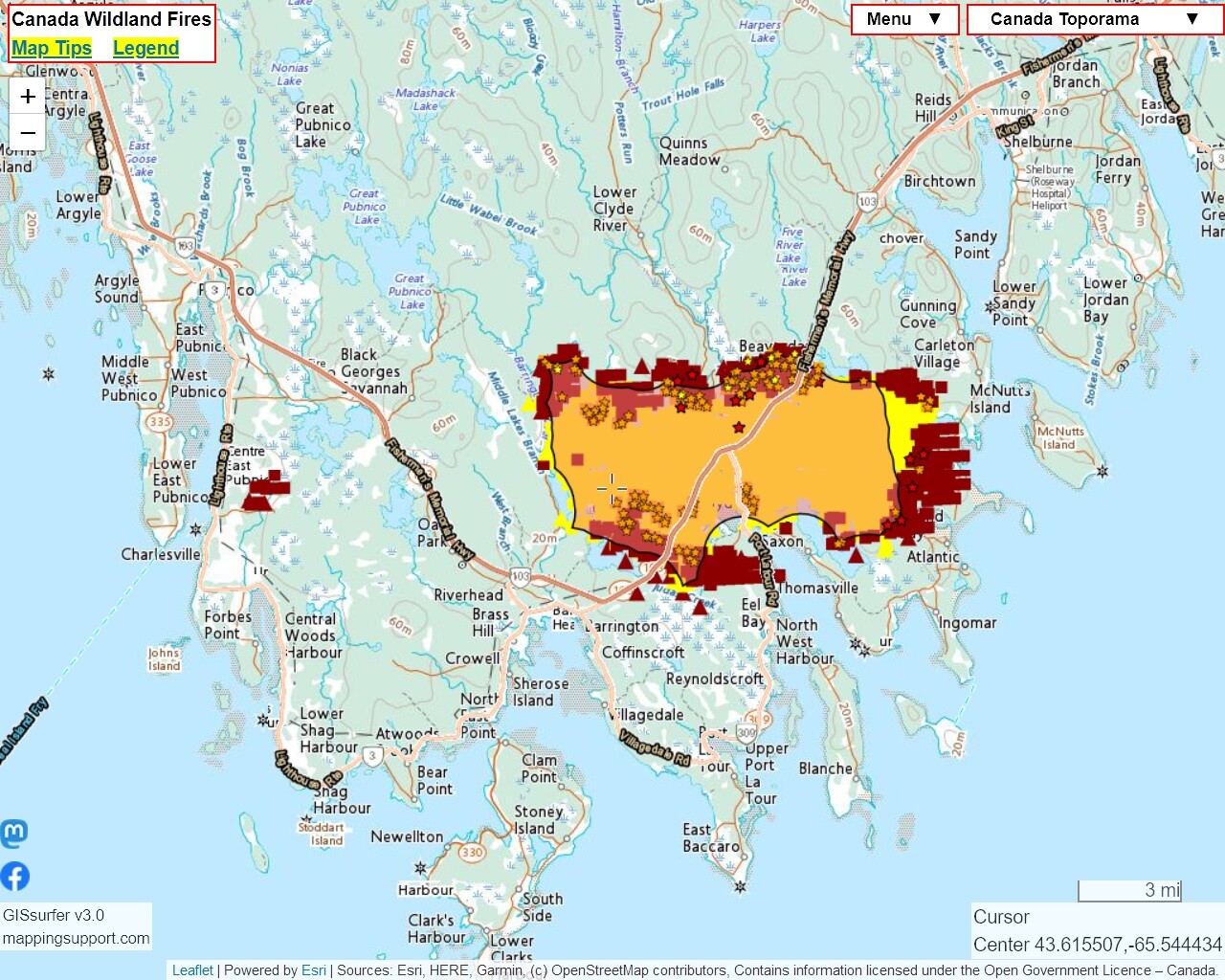
Mapping Support · @mappingsupport
97 followers · 14 posts · Server m.ai6yr.org
Here is a version of the Canada #wildfire map I produce that is centered at the #BarringtonLakeFire in #NovaScotia.
The ‘GOES East’ basemap (zoom out) shows the wind out of the north.
The map has other GIS overlay layers you can turn on including MODIS and VIIRS heat detections. For help, see the “Map tips” link in the upper left corner.
#Barrington #BarringtonLake
Open #GISsurfer map:
https://mappingsupport.com/p2/gissurfer.php?center=43.626746,-65.471649&zoom=12&basemap=Canada_Toporama&overlay=CA_M3_hotspots_last_24_hours ,CA_fire_perimeter,CA_province_boundary_blue&txtfile=https://mappingsupport.com/p2/special_maps/disaster/Canada_wildland_fire.txt
#Wildfire #barringtonlakefire #novascotia #barrington #barringtonlake #gissurfer