J9Cody :arcgis: :python: 🛰️ · @J9C
84 followers · 86 posts · Server mapstodon.spaceA new topobathymetric lidar dataset for the Potomac River from the #USGS 3D Elevation Program (3DEP) is available for download. Uses: estimating concentrations of contaminant plumes; engineering for bridges and roads; mapping aquatic habitats for biological assessments; and flood mapping.
https://www.usgs.gov/news/technical-announcement/new-usgs-national-map-data-reveals-potomac-rivers-submerged-topography
#ICPRB #potomacriver #3dep #lidar #gischat #bathymetry #TopographyTuesday
#USGS #icprb #potomacriver #3dep #lidar #gischat #bathymetry #topographytuesday
GregCocks · @GregCocks
608 followers · 551 posts · Server techhub.socialNew USGS National Map Data Reveals The Potomac River’s Submerged Topography
--
https://www.usgs.gov/news/technical-announcement/new-usgs-national-map-data-reveals-potomac-rivers-submerged-topography <-- shared technical article
--
#GIS #spatial #mapping #remotesensing #LiDAR #opendata #HarpersFerry #westvirginia #virginia #USA #potomac #river #water #hydrology #hydrospatial #TheNationalMap #USGS #ICPRB #bathymetry #topobathy #elevation #3dep #3dntm #inflationreductionact #riverflow #appliedscience #model #modeling #fateandtransport #waterquality #waterresources #waterresourcemanagement #engineering #infrastructure #transportation #usecase #ecosystems #environment
@usgs
#gis #spatial #mapping #remotesensing #lidar #opendata #harpersferry #westvirginia #virginia #USA #potomac #river #water #hydrology #hydrospatial #thenationalmap #usgs #icprb #bathymetry #topobathy #elevation #3dep #3dntm #inflationreductionact #riverflow #appliedscience #model #modeling #fateandtransport #waterquality #waterresources #waterresourcemanagement #engineering #infrastructure #transportation #usecase #ecosystems #Environment
· @gishubio
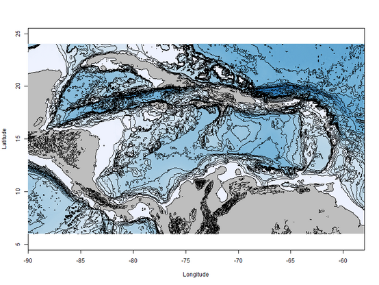
0 followers · 3 posts · Server fosstodon.orgWorking with bathymetry data in R, https://www.gishub.io/2023/08/26/working-with-bathymetry-data-in-r/
#rspatial #noaa #gis #bathymetry
Josh Carlson :qgis: · @jcarlson
441 followers · 845 posts · Server mapstodon.spaceLearned about this fun #GIS dataset on a regional IL GIS call recently.
https://www.sciencebase.gov/catalog/item/64419ae4d34ee8d4ade7c239
It's a #bathymetry point cloud of the #Chicago River and Ship Canal, and it's detailed enough to spot cars!
GregCocks · @GregCocks
544 followers · 488 posts · Server techhub.socialA New Approach To Satellite-Derived Bathymetry - An Exercise In Seabed 2030 Coastal Surveys
--
https://doi.org/10.3390/rs14184484 <-- shared paper
--
#GIS #spatial #mapping #satellitederivedbathymetry #SDB #nauticalcharting #machinelearning #IHOstandards #GEBCO #Seabed2030 #radiativetransferequation #RTE #remotesensing #satellite #model #modeling #hydrography #hydrospatial #marine #charts #navigation #nautical #gischat #bathymetry #topobathy #automation #ESA
#gis #spatial #mapping #satellitederivedbathymetry #sdb #nauticalcharting #machinelearning #ihostandards #gebco #seabed2030 #radiativetransferequation #rte #remotesensing #satellite #model #modeling #hydrography #hydrospatial #marine #charts #navigation #nautical #gischat #bathymetry #topobathy #automation #Esa
GregCocks · @GregCocks
508 followers · 473 posts · Server techhub.social7% 25% Of The Ocean Floor Mapped From 2017 (Seabed 2030)
--
https://seabed2030.org/ <-- @Seabed2030 web site
--
H/T Dennis Haines
“🗺 Did you know that in 2017, only 6% of the world’s seafloor had been mapped to modern standards? Considering the ocean spans some 70% of the Earth’s surface, that’s a significant gap!
But over the past five years since Seabed 2030 launched, we’ve been able to map almost 25% of the ocean floor.
By discovering more about the seabed, we gain a greater understanding of our environment and can ensure its protection. After all, we can’t protect what we don’t know…”
#seabed2030 #mappingthefuture #oceanscience #hydrospatial
#GIS #spatial #mapping #seabed2030 #mappingthefuture #oceanscience #hydrospatial #ocean #marine #bathymetry #topobathy #remotesensing #sonar #satellite #charts #navigation #oceanmapping #seafloor #Seabed2030 #oceanfloor #oceanconservation #environment #oceanography #marineenvironment #marineconservation #gischat
#seabed2030 #mappingthefuture #oceanscience #hydrospatial #gis #spatial #mapping #ocean #marine #bathymetry #topobathy #remotesensing #sonar #satellite #charts #navigation #oceanmapping #seafloor #oceanfloor #OceanConservation #Environment #oceanography #marineenvironment #marineconservation #gischat
GregCocks · @GregCocks
396 followers · 431 posts · Server techhub.socialSometimes it is extra nice to have fibre at the house...
2.3Gb down in < 5 minutes...
--
https://topotools.cr.usgs.gov/topobathy_viewer/?region=majuro
#GIS #spatial #mapping #CoNED #opendata #topobathy #hydrospatial #gischat #bathymetry #elevation #remotesensing #MajuroAtoll #MarshallIslands #WFH #homeoffice
@usgs
#gis #spatial #mapping #coned #opendata #topobathy #hydrospatial #gischat #bathymetry #elevation #remotesensing #majuroatoll #marshallislands #WFH #homeoffice
Anton van Tetering · @studiohaverstraat
100 followers · 69 posts · Server mapstodon.spaceMade a map of the sea depth around Greece (deepest point SW of Peloponnesos = around 5100 m deep). Curious about the origin of the structures west of Kefalonia.
Map data: emodnet bathymetry dtm #bathymetry #geology #greece #maps
#bathymetry #geology #greece #maps
Jonathan Reeve Price · @jonathanreeveprice
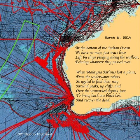
20 followers · 146 posts · Server newsie.socialHow little we know of the terrain at the bottom of the sea. #seafloor #bathymetry #soundings #submersible #titanic #sonar #geology #visualpoem #map #ocean
https://www.mdpi.com/2076-3263/8/2/63 museumzero.art
#seafloor #bathymetry #soundings #submersible #titanic #sonar #geology #visualpoem #map #ocean
Rafagas Links · @rafagaslinks
137 followers · 440 posts · Server en.osm.townThe increasing availability of high-resolution bathymetry data is facilitating the emergence of a new generation of seabed geological mapping in the UK #bathymetry
GregCocks · @GregCocks
281 followers · 366 posts · Server techhub.social3D Nation Study Hub Site Now Available! [NOAA + USGS]
--
https://nauticalcharts.noaa.gov/updates/3d-nation-study-hub-site-now-available/ <-- NOAA technical article / ‘press release’
--
https://iocm.noaa.gov/planning/3DNationStudy.html <-- NOAA 3D Nation Elevation Requirements and Benefits Study
--
#GIS #spatial #mapping #elevation #opendata #bathymetry #webportal #data #businesscase #offshore #benefits #benefitsstudy #3D #data #terrestrial #marine #offshore #hydrospatial #usecase #national #USA #datasets #datacollection #planning #3DNation #3DTNM #3DEP #topobathy #topographic #bathymetric #coast #coastal #businessuse #maps #CoNED #gischat #NOAA #USGS
@NOAA @USGS
#gis #spatial #mapping #elevation #opendata #bathymetry #webportal #data #businesscase #offshore #benefits #benefitsstudy #3d #terrestrial #marine #hydrospatial #usecase #national #USA #datasets #datacollection #planning #3dnation #3dtnm #3dep #topobathy #topographic #bathymetric #coast #coastal #businessuse #Maps #coned #gischat #noaa #usgs
· @stib
514 followers · 462 posts · Server aus.socialPro tip for anyone who happens to be looking for high resolution #bathymetry and #topography data. Nasa's publicly available images top out at 3.6k pixels wide, which might not be enough for say a detailed 3D model. But if you go to the web page where they're available e.g. https://neo.gsfc.nasa.gov/view.php?datasetId=GEBCO_BATHY and click one of the download links, it actually renders the data live. So if you hack the URL you can dial up any* resolution you want.
The URL for the bathymetry data for example ends with `&format=PNG&width=3600&height=1800`. If you want an image with say, 10 times the resolution, just add a zero to both dimensions.
*Not sure what the upper limit is, or what resolution the original data set is. Don't abuse it or it might get taken away.
#NoteForFutureSelf #blender3d #dataVis
#bathymetry #topography #noteforfutureself #blender3d #datavis
Rafagas Links · @rafagaslinks
128 followers · 400 posts · Server en.osm.townSatellite-derived bathymetry (SDB) with Sentinel-2A/B imagery retrieves depths down to 14 m with an average bias of 0.02 m and an average absolute error of 0.71 m compared to echosounder data multi beam #bathymetry
https://www.sciencedirect.com/science/article/pii/S1569843223001504
GregCocks · @GregCocks
233 followers · 291 posts · Server techhub.socialWhat Is A Digital Elevation Model (DEM)?- A Practical Guide
--
https://equatorstudios.com/what-is-a-digital-elevation-model-dem <-- shared tutorial
--
“A Digital Elevation Model (DEM) is a digital cartographic dataset that represents a continuous topographic elevation surface through a series of cells. Each cell represents the elevation (Z) of a feature at its location (X and Y). Digital Elevation Models are a “bare earth” representation because they only contain information about the elevation of geological (ground) features, such as valleys, mountains, and landslides, to name a few. They do not include any elevation data concerning non-ground features, such as vegetation or buildings...”
#GIS #spatial #mapping #elevation #spatialdata #spatialanalysis #data #digital #DEM #digitalelevationmodel #spatialanalysis #LiDAR #remotesensing #model #modeling #IFSAR #onlinelearning #onlinelessons #tutorial #landform #bathymetry #geomorphology #geology #landforms
#gis #spatial #mapping #elevation #spatialdata #spatialanalysis #data #digital #dem #digitalelevationmodel #lidar #remotesensing #model #modeling #ifsar #onlinelearning #onlinelessons #tutorial #landform #bathymetry #geomorphology #geology #landforms
Chuixiang (Tree) Yi · @TreeYi
9 followers · 3835 posts · Server mastodon.worldRT @geo_spatialist
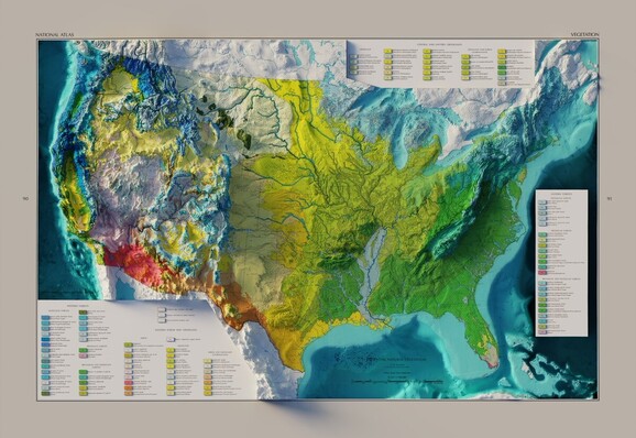
US Potential Natural Vegetation - USGS - National Atlas - 1966
3D render - with and without bathymetry
#arcgispro #b3d #GIS #geography #bathymetry #cartography
GregCocks · @GregCocks
196 followers · 250 posts · Server techhub.socialGodzilla Gets a Forever Home on the Ocean Floor
--
https://eos.org/articles/godzilla-gets-a-forever-home-on-the-ocean-floor <-- shared article
--
#GIS #spatial #mapping #bathymetry #hydrospatial #marine #godzilla #pacificocean #japan #nautical #charts #GodzillaMegamullionProvince #ocean #seafloor #seabed #megamullion #midoceanridges #geology #tectonics #GodzillaMegamullion #oceaniccorecomplex #structuralgeology #survey
#gis #spatial #mapping #bathymetry #hydrospatial #marine #godzilla #pacificocean #Japan #nautical #charts #godzillamegamullionprovince #ocean #seafloor #seabed #megamullion #midoceanridges #geology #tectonics #godzillamegamullion #oceaniccorecomplex #structuralgeology #survey
GregCocks · @GregCocks
177 followers · 213 posts · Server techhub.socialThe World in Relief on ETOPO [2022]
--
https://www.ncei.noaa.gov/news/world-relief-etopo <-- shared article
--
https://www.ncei.noaa.gov/products/etopo-global-relief-model <-- open data access
--
#GIS #spatial #mapping #remotesensing #opendata #openaccess #NCEI #ETOPO #topography #elevation #bedrock #icesurface #ice #hydrospatial #bathymetry #topobathy #ETOPO2022 #model #modeling #global #earth #wholeearth #gischat #noaa #NCEI
@NOAA @NCEI
#gis #spatial #mapping #remotesensing #opendata #openaccess #ncei #etopo #topography #elevation #Bedrock #icesurface #ice #hydrospatial #bathymetry #topobathy #etopo2022 #model #modeling #global #earth #wholeearth #gischat #noaa
GregCocks · @GregCocks
177 followers · 210 posts · Server techhub.socialImproving Coastal Resiliency With Digital Elevation Models [NOAA / NCEI]
--
https://www.ncei.noaa.gov/news/improving-coastal-resiliency-digital-elevation-models <-- shared article
--
https://www.ncei.noaa.gov/maps/bathymetry/ <-- NOAA NCEI Bathymetry Viewer
--
https://coast.noaa.gov/dataviewer/#/lidar/search/ <-- NOAA Office for Coastal Management’s Digital Coast: Data Access Viewer
--
#GIS #spatial #mapping #Oceans #Bathymetry #Maps #DataVisualization #Models #modeling #environmental #water #hydrology #hydrospatial #hydrography #bathymetry #topobathy #coast #coastal #climatechange #resiliency #mitigation #planning #prediction #elevation #DEM #flooding #sealevelrise #SLR #sealevel #NCEI #NOAA #USGS #CUDEMS #ETOPO #event #hazard #tsunami #remotesensing #extremeweather #hurricane #planning #spatialanalysis #coastalresilience #coastalcommunities #coastaldesign #stormsurge
#remotesensing #gis #spatial #mapping #oceans #bathymetry #Maps #datavisualization #models #modeling #environmental #water #hydrology #hydrospatial #hydrography #topobathy #coast #coastal #climatechange #resiliency #mitigation #planning #prediction #elevation #dem #flooding #sealevelrise #slr #sealevel #ncei #noaa #usgs #cudems #etopo #event #hazard #tsunami #extremeweather #hurricane #spatialanalysis #coastalresilience #coastalcommunities #coastaldesign #stormsurge
IBCSO · @ibcso
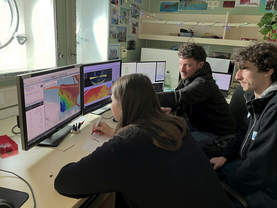
12 followers · 16 posts · Server masto.ai#Polarstern spent 4 days in Eltanin Bay conducting a geological survey and selecting core sites. This area is largely unmapped and therefore a great chance to collect new hi-res bathymetric data! A major interest is to understand the geomorphic structures created by the ice flow. #AWI
#geoscience #oceanography #ocean #antarctica #antarktis #bathymetry #science #earthscience #seafloor #southernocean #data #survey
#polarstern #awi #geoscience #oceanography #ocean #antarctica #antarktis #bathymetry #science #earthscience #seafloor #southernocean #data #survey
IBCSO · @ibcso
12 followers · 15 posts · Server masto.aiRonne Entrance is the southern entrance from Bellingshausen Sea to George VI Sound. Although it was discovered by Finn Ronne in 1940, only a few have mapped small sections in high resolution. #Polarstern contributes an area 5.5 times the size of #Bremen in unprecedented detail. #AWI
#geoscience #oceanography #ocean #antarctica #antarktis #bathymetry #science #earthscience #seafloor #southernocean #data #survey
#polarstern #bremen #awi #geoscience #oceanography #ocean #antarctica #antarktis #bathymetry #science #earthscience #seafloor #southernocean #data #survey


