
RustyLMehlberg · @RustyMehlberg
110 followers · 522 posts · Server newsie.social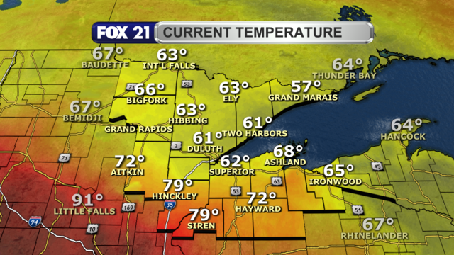
Happy #Tuesday #Northland!
Thanks to a #lake #breeze, most of us are enjoying a #cool day with some #drizzle and #fog in the #TwinPorts.
However, the #heat and #humidity is building in the southern region of #Pine and #Burnett counties, and eventually #Washburn and #Sawyer.
Heat #Advisory alerts are in place through Wednesday, where it could feel around 100°.
#tuesday #northland #lake #breeze #cool #drizzle #fog #twinports #heat #humidity #pine #burnett #washburn #sawyer #advisory #wxtooter #weather #mnwx #wiwx #upwx
RustyLMehlberg · @RustyMehlberg
102 followers · 473 posts · Server newsie.socialSEVERE THUNDERSTORM WARNING:
A new #Severe #Thunderstorm #Warning is in effect for southern #Burnett and southwest #Washburn counties until 4:45 p.m.
#Winds could gust up to 60 mph, and any #hail could be up to 1" in diameter.
Greatest threat remains for spots south of Highway 70.
#severe #thunderstorm #warning #burnett #washburn #winds #hail #wxtooter #weather #wiwx
RustyLMehlberg · @RustyMehlberg
102 followers · 471 posts · Server newsie.socialNothing like having to come in on your day off due to #severe #weather.
A severe #thunderstorms with #winds up to 80 mph is passing through southern #Pine County and southern #Burnett County through 4:30 p.m.
Anyone south of Highway 70 should seek a safe place.
Meanwhile, a severe thunderstorm #watch remains in effect for Pine, Burnett, #Washburn, and #Sawyer counties until 10 p.m. for possible #hail and high winds.
#severe #weather #thunderstorms #winds #pine #burnett #watch #washburn #sawyer #hail #wxtooter #mnwx #wiwx

EAS Watcher · @easwatch
328 followers · 9264 posts · Server m.ai6yr.org
#EAS for Pine, #MN; #Burnett, #WI: National Weather Service: SEVERE THUNDERSTORM WARNING in effect for this area until 4:15 PM CDT for DESTRUCTIVE 80 mph winds. Take shelter in a sturdy building, away from windows. Flying debris may be deadly to those caught without shelter. Source: NWS Duluth MN** DO NOT RELY ON THIS FEED FOR LIFE SAFETY, SEEK OUT OFFICIAL SOURCES ***

» P I E T . L U « · @PietLu
160 followers · 725 posts · Server nrw.socialDiese Körperklauswürfe von #Burnett sind der Hammer. Man fragt sich, wie er mit diesem Antiwurfstil überhaupt das Board trifft.

EAS Watcher · @easwatch
96 followers · 854 posts · Server m.ai6yr.org#EAS for Pine, ##MN; ##Burnett, ##WI: National Weather Service: Snow Squall Warning until 5:15 PM CST. Slow down or delay travel! Be ready for a sudden drop to near zero visibility and icy roads in heavy snow. ***EXPERIMENTAL***EXPERIMENTAL*** DO NOT RELY ON THIS FEED FOR LIFE SAFETY, SEEK OUT OFFICIAL SOURCES *EXPERIMENTAL*
EAS Watcher · @easwatch
96 followers · 853 posts · Server m.ai6yr.org
EAS Watcher · @easwatch
96 followers · 852 posts · Server m.ai6yr.org#EAS for #Pine, ##MN; ##Burnett, ##WI: National Weather Service: Snow Squall Warning until 5:15 PM CST. Slow down or delay travel! Be ready for a sudden drop to near zero visibility and icy roads in heavy snow. ***EXPERIMENTAL***EXPERIMENTAL*** DO NOT RELY ON THIS FEED FOR LIFE SAFETY, SEEK OUT OFFICIAL SOURCES *EXPERIMENTAL*