
HumToTable · @HumToTable
334 followers · 5641 posts · Server sfba.social

Cecilia Mjausson Huster · @mjausson
249 followers · 5281 posts · Server mastodon.design@sarahstierch Red flag warning for hilly parts of #NapaCounty and #SonomaCounty starts tonight at 11 pm and ends at 8 pm on Wednesday.
See @sarahstierch post above for more detail and a map.
#napacounty #SonomaCounty #napa #sonoma #CAwx #cafire #bayarea
Cecilia Mjausson Huster · @mjausson
246 followers · 5231 posts · Server mastodon.designBay Area weather forecast: Increasingly hot and windy until Wednesday, but not fire weather yet.
Rapid cooldown Thursday-Friday. Slight chance of showers on the weekend.
https://bots.krohsnest.com/@iembot_mtr/110968646025918023 #BayArea #BayAreaWeather #caFire #cawx
#bayarea #bayareaweather #cafire #CAwx
Cecilia Mjausson Huster · @mjausson
246 followers · 5224 posts · Server mastodon.design
Santa Cruz fire at Pogonip Open Space Preserve.
Details on Watch Duty.
https://app.watchduty.org/incident/11669 #SantaCruz #cawx #caFire #pogonip
#santacruz #CAwx #cafire #pogonip
Cecilia Mjausson Huster · @mjausson
246 followers · 5211 posts · Server mastodon.design
Wildfire along Hwy 101 south of #Willits in #Mendocino County. Impacting traffic on 101.
Details on Watch Duty
https://app.watchduty.org/incident/11617
Traffic
https://www.google.com/maps/place/Willits,+CA+95490/@39.3526758,-123.3544321,10391m/data=!3m1!1e3!4m6!3m5!1s0x80818b0b29921bb3:0xc85d711b54770f0a!8m2!3d39.4096079!4d-123.3555656!16zL20vMHIxcm4!5m1!1e1?entry=ttu
#caFire #cawx #california
#willits #mendocino #cafire #CAwx #california
Cecilia Mjausson Huster · @mjausson
243 followers · 5157 posts · Server mastodon.design
HumToTable · @HumToTable
330 followers · 5462 posts · Server sfba.social
Kym Kemp does a good breakdown on the current state of the Smith River Complex fire.
#SmithRiverComplex
#SRFSmithRiverComplex
#CAfire
#DelNorteCounty
#Humboldt
#JosephineCounty
https://kymkemp.com/2023/08/24/smith-river-complex-firefighters-battle-red-flag-warnings-and-shifting-conditions/
#smithrivercomplex #srfsmithrivercomplex #cafire #delnortecounty #Humboldt #josephinecounty

Joseph Elfelt · @mappingsupport
504 followers · 433 posts · Server m.ai6yr.org
#RedFlagWarning includes *west* slopes of Cascade Mountains.
For details - including timing - open the map, zoom in, click your area of interest, follow the link.
Click “Map tips” upper left corner for more info.
#PNW #WAfire #WAwx #ORfire #ORwx #CAfire #CAwx #Wildfire #GIS
Open #GISsurfer map:
https://mappingsupport.com/p2/gissurfer.php?center=44.237006,-122.563477&zoom=6&basemap=USA_basemap&overlay=State_boundary,Weather_watch_warning&data=https://mappingsupport.com/p2/special_maps/disaster/USA_weather.txt
#redflagwarning #pnw #wafire #wawx #orfire #orwx #cafire #cawx #Wildfire #gis #gissurfer
Cecilia Mjausson Huster · @mjausson
242 followers · 5122 posts · Server mastodon.design
Fire by 880 through Oakland at the 66th Ave exit. It's on the Bay side near Oakport Ave.
Firefighters already have a line around it, so it doesn't pose a risk. No obvious impact to traffic in the area.
Deets on Watch Duty https://app.watchduty.org/incident/11350 #cawx #caFire #wildfire #EastBay #Oakland #BayArea
#CAwx #cafire #wildfire #eastbay #oakland #bayarea
Cecilia Mjausson Huster · @mjausson
240 followers · 5008 posts · Server mastodon.design
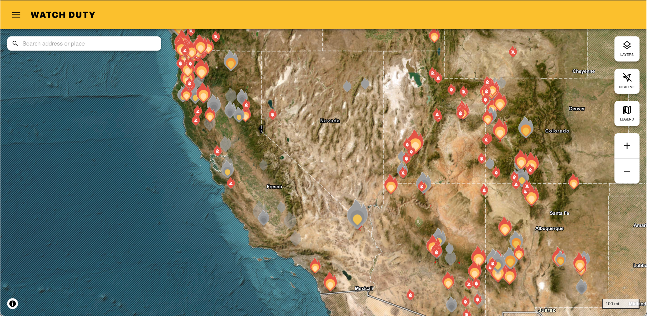
Right now almost all the fires in California are in the north-west corner of the state.
Screenshot from Watch Duty, https://app.watchduty.org/ #cafire #cawx
Cecilia Mjausson Huster · @mjausson
240 followers · 4994 posts · Server mastodon.designLearning from disaster: The Northern California town of Paradise has installed sirens. Paradise was were the Camp Fire killed 84 people 5 years ago.
The sirens are one of several measures that returning residents said were required to make them feel safe again. They will be tested on a monthly basis and can be triggered remotely. They also have solar backup power, in addition to hardwired mains power. #caFire #cawx #campfire
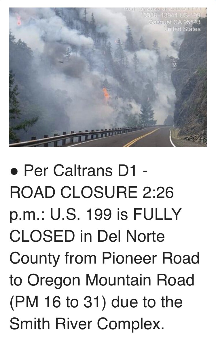
HumToTable · @HumToTable
323 followers · 5266 posts · Server sfba.social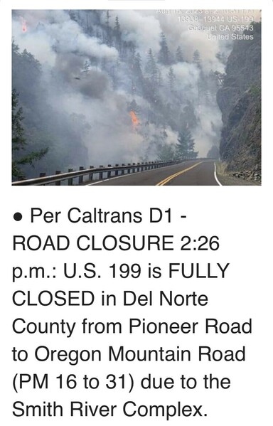
I really need to stop doomscrolling for the day. The fire closest to us seems to be holding. Just about cried seeing this, so time for a break. Travelled 199 not that long ago, and the whole Smith river area is so lovely. Hate to see it in flames. 😥
#wildfire
#SRFSmithRiverComplex
#CAfire
#wildfire #srfsmithrivercomplex #cafire
Cecilia Mjausson Huster · @mjausson
240 followers · 4979 posts · Server mastodon.design
New fire East of Hwy 101 North of Morgan Hill. Potential to spread up to 10 acres. Reported shortly after 5 pm. Smoke may impact evening commute. It's called the #CochraneFire.
Follow updates on WatchDuty https://app.watchduty.org/incident/10660
#cochranefire #cafire #CAwx #bayarea #southbay
HumToTable · @HumToTable
323 followers · 5266 posts · Server sfba.socialSo many fires. AQI not too bad here. Bit of ash on the cars. CalFire planes went late yesterday and were at it again at first light. Just saw a helicopter hauling a bucket head out from the airport. They're not messing around. It's all hands on deck. Thankfully not much wind at the moment but this afternoon will be a different story.
#CAfire
Cecilia Mjausson Huster · @mjausson
241 followers · 4963 posts · Server mastodon.design
Worrying fire in Siskiyou County, north of Klamath National Forest on Highway 96. It's currently 3,000 acres and 0% containment.
Evacuation orders and warnings are in effect. The name of the fire is #HeadFire.
Follow updates on WatchDuty at https://app.watchduty.org/i/10530 #caFire #cawx

Geewhizpat · @Geewhizpat
893 followers · 2716 posts · Server newsie.social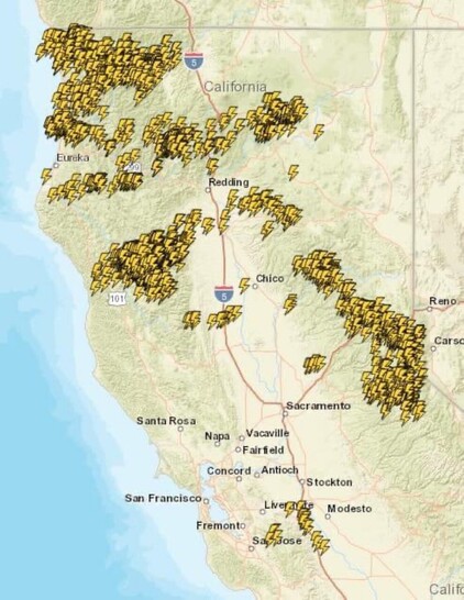
Via hotshot Wakeup: NorCal: 3,800 strikes in 24 hours.
#cali #cafire #california #weather #wildfire
#cali #cafire #california #weather #wildfire
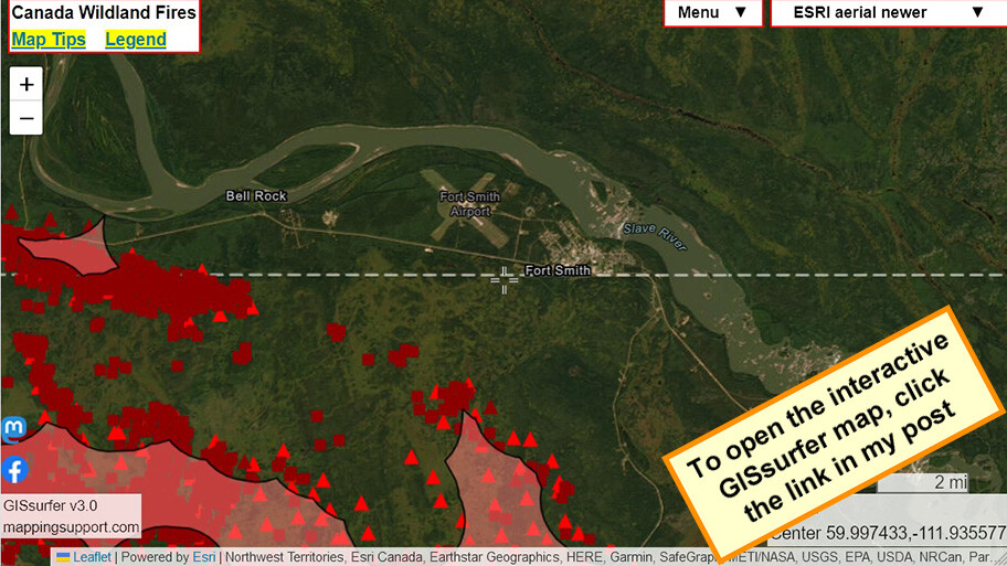
Joseph Elfelt · @mappingsupport
464 followers · 383 posts · Server m.ai6yr.org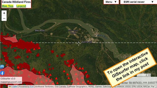
Interactive #GIS map showing MODIS and VIIRS satellite *heat* detections for wildfire near #FortSmith Northwest Territories, Canada. The town has been ordered to evacuate,
#NWT #NorthwestTerritories #NWTfire #CAfire
Open #GISsurfer map:
https://mappingsupport.com/p2/gissurfer.php?center=59.997433,-111.935577&zoom=11&basemap=ESRI_aerial_newer&overlay=MODIS_7_day,VIIRS_7_day,CA_fire_perimeter&txtfile=https://mappingsupport.com/p2/special_maps/disaster/Canada_wildland_fire.txt
#gis #fortsmith #nwt #northwestterritories #nwtfire #cafire #gissurfer
Cecilia Mjausson Huster · @mjausson
236 followers · 4894 posts · Server mastodon.designIf you lived through a deadly wildfire and feel awful reading about #Lahaina, reading this article from the POV of Camp fire survivors may help you feel a little better.
Maui fire: ‘This whole town of Paradise knows exactly what they’re feeling.’ Survivors of California’s deadliest wildfire reliving trauma through scenes of devastation in Hawaii. #wildfire #caFire #cawx #trauma
#lahaina #wildfire #cafire #CAwx #trauma
Cecilia Mjausson Huster · @mjausson
233 followers · 4828 posts · Server mastodon.design
Fire in San Benito County potentially visible from I-5 or 101. It's located on the East side of CA-25, i.e. not inside Pinnacles National Park. #caFire #cawx #wildfires
Cecilia Huster · @mjausson
221 followers · 4657 posts · Server mastodon.design
Prescribed burn south of Briones Reservoir near Orinda in Contra Costa County today through Friday.
#bayarea #cafire #orinda #eastbay