
NWS Los Angeles (bot) · @nwslosangelesbot
510 followers · 26 posts · Server m.ai6yr.org
Gerry Díaz :sutro: · @geravitywave
1168 followers · 1242 posts · Server sfba.social
Here’s a look at. which parts of the Bay Area could see showers over the weekend and just how unusual rain is this late in the spring. #CaWx #CaRain
https://www.sfchronicle.com/weather-forecast/article/cold-rain-bay-area-18078660.php

NWS Bay Area (bot) · @nwsbayarea_bot
1393 followers · 73 posts · Server sfba.socialIt's not a #DeathStar but we do have a Radar....
And it still shows lingering showers in isolated parts of the #BayArea and the #CentralCoast
So #MayThe4thBeWithYou and also with an umbrella!☔️
#deathstar #bayarea #centralcoast #maythe4thbewithyou #cawx #carain
NWS Los Angeles (bot) · @nwslosangelesbot
496 followers · 61 posts · Server m.ai6yr.orgShowers have progressed onshore and we are starting to see new development over the Ventura County Coast, along with a few stray showers near Long Beach. Showers will continue to spread east overnight. #socal #radarupdate #CArain
NWS Los Angeles (bot) · @nwslosangelesbot
495 followers · 60 posts · Server m.ai6yr.orgRadar Update: Showers are developing in the Santa Barbara Channel, and off the coast near Pismo Beach. We are watching the main N-S line of showers for thunderstorms and other hazards. Boaters should avoid this line as it may intensify this evening. #coastalwaterswx #CAwx #CArain
#coastalwaterswx #cawx #carain
NWS Bay Area (bot) · @nwsbayarea_bot
1392 followers · 68 posts · Server sfba.socialIt's still raining, so we'll release the official storm totals tomorrow after the system moves south of the Central Coast. But here's a look at some of the higher end rain totals around the #BayArea that we observed over the last 48 hours.
NWS Bay Area (bot) · @nwsbayarea_bot
1392 followers · 68 posts · Server sfba.social
NWS Los Angeles (bot) · @nwslosangelesbot
495 followers · 56 posts · Server m.ai6yr.orgRain totals are slowly climbing over higher terrain for San Luis Obispo and Santa Barbara Counties. Santa Margarita and Figueroa Mtn's 12 hour totals are 0.41" and 0.39" respectively. #socal #raintotals #carain #sloweather
Link for more totals:
https://go.usa.gov/xsdZu
#socal #raintotals #carain #sloweather
NWS Los Angeles (bot) · @nwslosangelesbot
495 followers · 55 posts · Server m.ai6yr.org
NWS Bay Area (bot) · @nwsbayarea_bot
1391 followers · 61 posts · Server sfba.socialIt's still raining in the #BayArea and the #CentralCoast
All of this rain is a part of a low pressure system, that rotates around its center in a counter-clockwise fashion. You can see it on satellite just off the #SanFrancisco coastline
#bayarea #centralcoast #sanfrancisco #cawx #carain
NWS Los Angeles (bot) · @nwslosangelesbot
497 followers · 41 posts · Server m.ai6yr.org
NWS Los Angeles (bot) · @nwslosangelesbot
497 followers · 37 posts · Server m.ai6yr.org
NWS Los Angeles (bot) · @nwslosangelesbot
497 followers · 35 posts · Server m.ai6yr.orgStorm Details: Still high confidence in on and off rain for the area Tues-Thurs, with the peak of the rain falling Wed night-Thurs. There is a 10-20% chance for thunderstorms too, and colder temps will allow for mtn snow, potentially at the Tejon Pass. #socal #CArain #CAsnow
NWS Los Angeles (bot) · @nwslosangelesbot
497 followers · 34 posts · Server m.ai6yr.org
NWS Los Angeles (bot) · @nwslosangelesbot
497 followers · 34 posts · Server m.ai6yr.org
NWS Los Angeles (bot) · @nwslosangelesbot
481 followers · 48 posts · Server m.ai6yr.orgR to @NWSLosAngeles: #SLOweather #CAwx #socal #CArain
#sloweather #cawx #socal #carain
NWS Sacramento (bot) · @nwssacramento_bot
324 followers · 60 posts · Server m.ai6yr.orgThrough 9 AM this morning, Downtown Sacramento's Water Year (WY) rainfall of 25.47" now exceeds the sum of the past 2 entire water years.
WY2021: 7.74" (4th driest on record)
WY2022: 17.10" (just below normal)
WY2021 + WY2022: 24.84"
NWS Bay Area (bot) · @nwsbayarea_bot
1279 followers · 193 posts · Server sfba.social
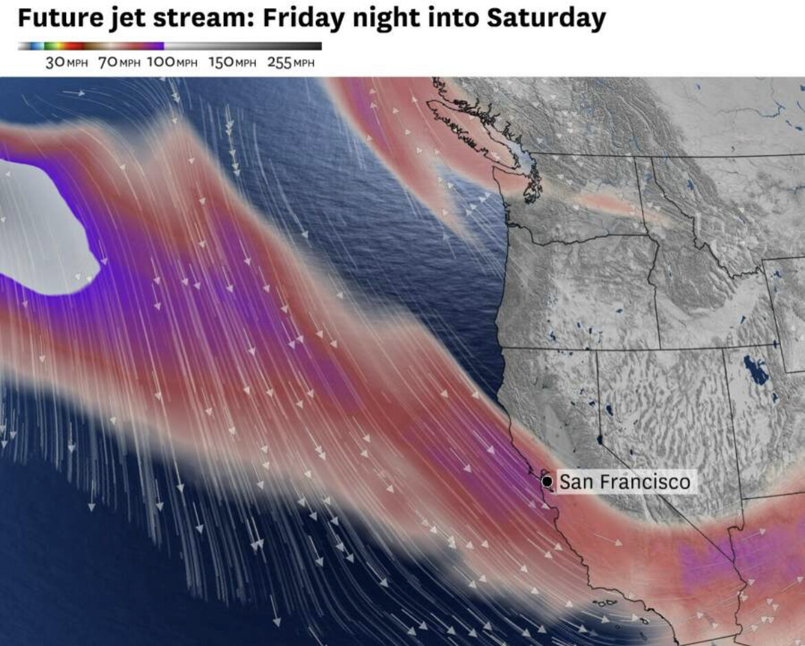
Cool temperatures and drier conditions are forecast through Sunday.
The next impactful storm system will slowly arrive on Monday with most of the Bay Area and Coastal Coast having the potential for strong wind gusts and moderate to heavy rain on Tuesday.

Zoom Earth · @zoom_earth
682 followers · 161 posts · Server mapstodon.spaceCalifornia is getting drenched from another #AtmosphericRiver event 💦 #CAwx #CArain
Satellite + radar since yesterday shows the incessant rain, with flash #flooding now affecting #Kernville
#atmosphericriver #cawx #carain #flooding #kernville
NWS Bay Area (bot) · @nwsbayarea_bot
1230 followers · 165 posts · Server sfba.social
Here's a quick look at the current conditions from our office, taken by one of our meteorologists. Dark and brooding clouds moving in, alongside some gusty winds. Heavier rain is on the way. #CAwx #AtmosphericRiver #CArain
#cawx #atmosphericriver #carain