
PR🪸🪼🧑💻 · @peterrenshaw
323 followers · 1121 posts · Server ioc.exchangeThis is why you can get a 1:2000 Ordinance map for any part of the UK.
“For centuries, though, no one had set out to systematically and accurately map the British isles in their entirety. It was not until the 19th century that os created the first comprehensive, detailed picture of #Britain. Just as today’s paper os #maps fit together in a jigsaw that stretches over the country, when os began its #cartographic project around 1800 it progressed sheet by sheet. The task would take eight decades and involved considerable hardship for the hundreds of #surveyors employed to carry it out.”
#ordinance #os / #cartography / #surveying <https://economist.com/interactive/britain/2023/04/06/how-intrepid-victorian-surveyors-mapped-the-length-and-breadth-of-britain>
#britain #maps #cartographic #surveyors #ordinance #os #cartography #surveying

Pierre Huyghebaert · @crickxson
798 followers · 1876 posts · Server post.lurk.org
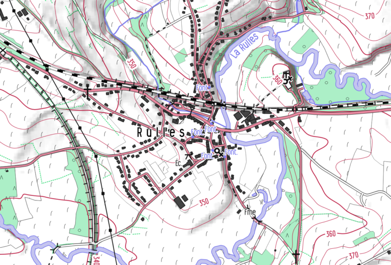
"From 2019, the #cartographic style #OpenArdenneMap is updated every 6 months. OpenArdenneMap is a cartographic style for topographic maps based on #OSM data.OpenArdenneMap was originally developed as a cartographic style with the #imposm importer and a #cartoCSS style derived from #OSMBright. Later the #osm2pgsqlimporter was used instead of the imposm. From 2023, the OpenArdenneMap is also available in #QGIS"
#mapnik #cartography #belgium
https://www.nobohan.be/2023/03/02/openardennemap-hiver-22-23/
#cartographic #OpenArdenneMap #osm #imposm #cartocss #osmbright #osm2pgsqlimporter #qgis #mapnik #cartography #belgium

Glen Pawelski · @macmapman
79 followers · 50 posts · Server mapstodon.spaceIssues 99 and 100 of #cartographic Perspectives are now available! #NACIS #maps #cartography #GIS #gischat
#cartographic #nacis #maps #cartography #GIS #gischat
Juggling With Eggs · @JugglingWithEggs
421 followers · 624 posts · Server mstdn.social
Further research into #Norwich ‘a old tram network has yeilded this fabulous #cartographic #sepiaphoto and recent film mashup! Am I the only person wanting to recreate this in 2022?
#sepiaphoto #cartographic #norwich

