
Poetry News · @haikubot
949 followers · 10291 posts · Server mastodon.cloudMichael Bobbitt of Cedar Key
Stood firm against Idalia's spree
His home still intact
Though damage was a fact
His community will rebuild with glee
#hurricaneidalia #cedarkey #rebuilding #florida #limerick #poetry
#hurricaneidalia #cedarkey #rebuilding #florida #limerick #poetry

karen · @geekaren
1031 followers · 658 posts · Server mstdn.social

La Chaîne Météo · @lachainemeteo
12 followers · 327 posts · Server techhub.socialL'ouragan #Idalia provoque une surcote allant jusqu'à 3 mètres. Ici, la ville de #CedarKey est complètement inondée ce mercredi matin. L'ouragan désormais en catégorie 3 remonte rapidement vers les Carolines qu'il touchera dans la nuit et ce jeudi.
https://twitter.com/JimCantore/status/1696844467829973031
🐦🔗 https://twitter.com/lachainemeteo/status/1696885834757050660
🕐 30/08 16:01

AI6YR · @ai6yr
4694 followers · 31944 posts · Server m.ai6yr.org
Cedar Key flooded, but surprised to not see much wind at all. Looks like it's still below most of the folks with pylons. #CedarKey #Idalia #hurricane #flooding
#cedarkey #idalia #hurricane #flooding
karen · @geekaren
1029 followers · 605 posts · Server mstdn.social

Athena Masson, PhD · @WeatherGoddess
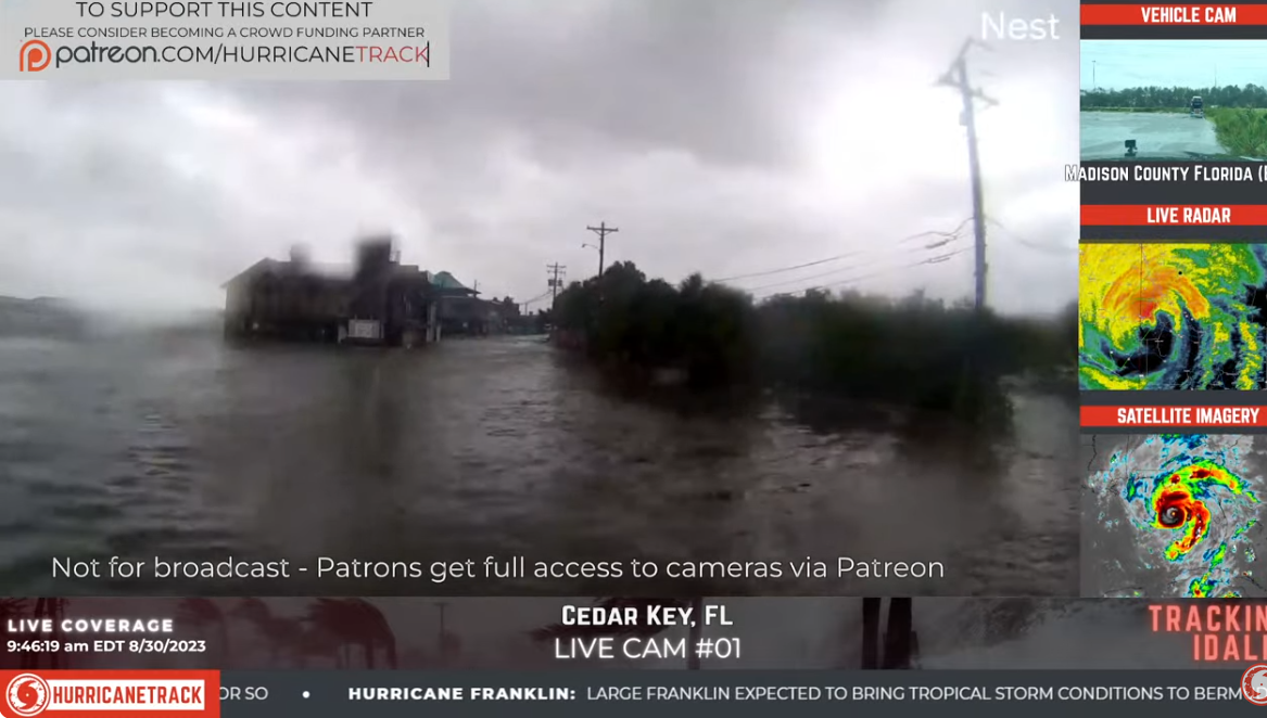
409 followers · 200 posts · Server journa.hostLive webcam at #CedarKey. Will look very different in the next few hours as the storm surge moves in as #Idalia passes and moves north of the area. #flwx. https://www.ipcamlive.com/cedarcoveresort

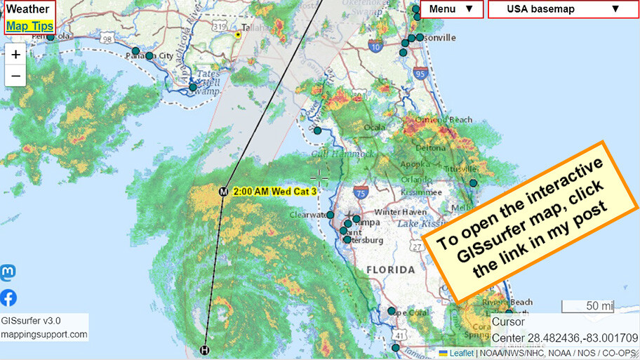
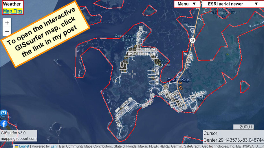
Joseph Elfelt · @mappingsupport
524 followers · 459 posts · Server m.ai6yr.org
For near real-time data on storm surge, open this interactive #GIS map, click any green dot and follow the link. Each dot is a coastal gage. The gage directly above the map center is at #CedarKey
Each time you open a gage data page you will see the latest data.
Each gage data page also has “Meteorlogical Obs” link with near real-time wind speed data.
#Idalia #HurricaneIdalia #Hurricane #Florida #FLwx #GAwx #Geospatial
#gis #cedarkey #idalia #hurricaneidalia #hurricane #florida #flwx #gawx #geospatial
Joseph Elfelt · @mappingsupport
521 followers · 457 posts · Server m.ai6yr.org
Got sea level rise?
If 10 foot sea level rise then areas shaded blue on this interactive #GIS map will be underwater. Sea level rise data is shown for all the USA coast.
Map opens at #CedarKey FL. Zoom in for detail.
Peak #StormSurge from #HurricaneIdalia at this location currently forecast at 10-15 feet.
#Idalia #Florida #Hurricane #FLwx #GAwx #SCwx #Geospatial
Open GISsurfer map:
https://mappingsupport.com/p2/gissurfer.php?center=29.143573,-83.048744&zoom=14&basemap=ESRI_aerial_newer&overlay=10ft_sea_level_rise,Country,USA_roads&data=https://mappingsupport.com/p2/special_maps/disaster/USA_weather.txt||overlay^name=10ft_sea_level_rise^url=https://www.coast.noaa.gov/arcgis/rest/services/dc_slr/conf_10ft/MapServer/tile/{z}/{y}/{x}^opacity=0.3
#gis #cedarkey #stormsurge #hurricaneidalia #idalia #florida #hurricane #flwx #gawx #scwx #geospatial
AI6YR · @ai6yr
4685 followers · 31658 posts · Server m.ai6yr.org@BakerRL75 @iembot_tbw #CedarKey #Yankeetown #FowlerBluff (yet... no official evac in that county yet 😬 )
#cedarkey #yankeetown #fowlerbluff

Shirley Eugest · @EugestShirley
91 followers · 677 posts · Server m.ai6yr.org
AI6YR · @ai6yr
4677 followers · 31515 posts · Server m.ai6yr.org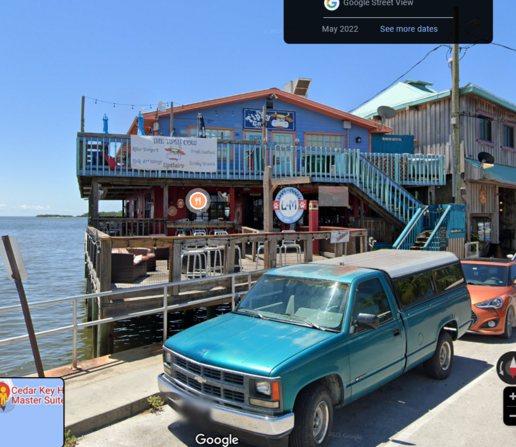
If those surge models pan out, that will be "The Floating Cow", not "The Tipsy Cow". We shall see. #CedarKey #FLwx #Idalia #TropicalStormIdalia #StormSurge
#cedarkey #flwx #idalia #tropicalstormidalia #stormsurge
AI6YR · @ai6yr
4677 followers · 31514 posts · Server m.ai6yr.org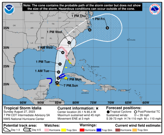
I dunno if anyone in #CedarKey #Florida is on the Fediverse, but I'd be hightailing it out of there right about now... just in case. Greater than 9 feet worth of storm surge currently forecast, and all routes to the mainland will be cut off. #FLwx (No official evac declared... yet)

Contrawhit · @contrawhit
193 followers · 95 posts · Server mastodon.worldThe graves were not the only shocking news the historical society found out about its cemetery. In a time when segregation was prominent in the South, the Cedar Key Cemetery was integrated.”
#history #cemetery #south #Florida #cedarkey #segregation #desegregation
#history #cemetery #south #florida #cedarkey #segregation #desegregation