
Matthew Bandy · @inti
172 followers · 189 posts · Server archaeo.social
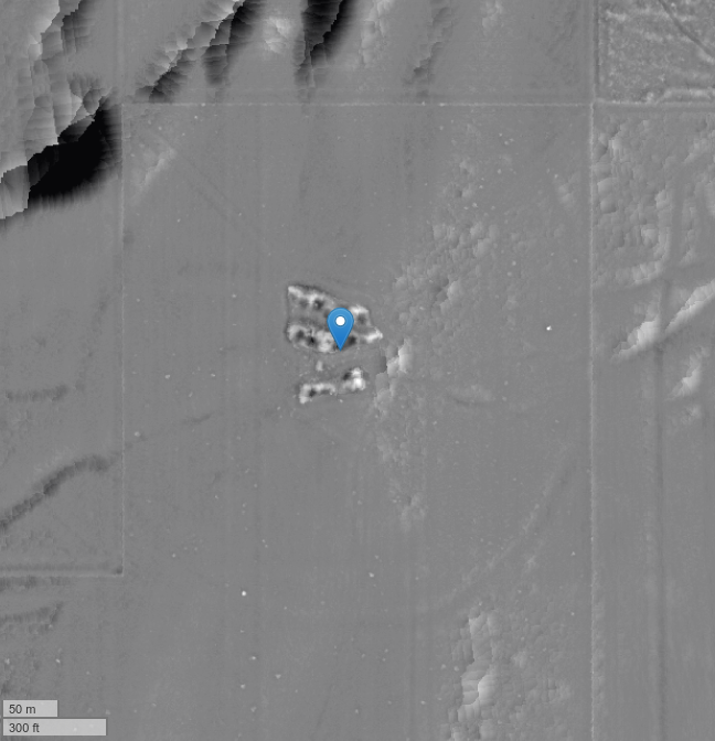
#archaeology #landscape #visualization from #lidar 21 - my 18th post on #ChacoanBeltRoads.
Here's a final example of a belt road-like feature from the very late prehistoric pueblo site of Pueblo Colorado (LA 476) in central #NewMexico. Aside from the belt road feature, there is a clear road running to the northeast. Also visible are numerous shallow pits surrounding the adobe architectural core. I interpret these as borrow pits for adobe production.
#archaeology #landscape #visualization #lidar #chacoanbeltroads #newmexico #archaeologylandscapevisualization
Matthew Bandy · @inti
172 followers · 179 posts · Server archaeo.social
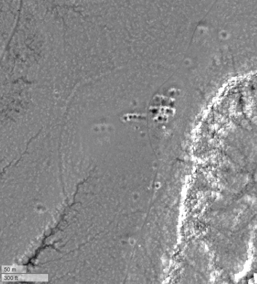
#archaeology #landscape #visualization from #lidar 20 - my 17th post on #ChacoanBeltRoads.
Most known examples of belt roads in the American southwest are from the northern San Juan and seem to be associated with chacoan period sites. As noted, race tracks in other areas are linear. There are very few examples from elsewhere. Here are two from the later (post-1300 CE) sites of Tovakwa and Totaskwina in the #Jemez mountains of central #NewMexico.
#archaeology #landscape #visualization #lidar #chacoanbeltroads #jemez #newmexico #archaeologylandscapevisualization
Matthew Bandy · @inti
169 followers · 178 posts · Server archaeo.social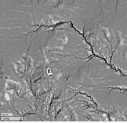
I like this one also, but apparently a post is limited to 4 images max.
Matthew Bandy · @inti
169 followers · 177 posts · Server archaeo.social
#archaeology #landscape #visualization from #lidar 19 - my 16th post on #ChacoanBeltRoads.
Apart from the belt roads I've show so far from #Coloado and #NewMexico, there are many in SE #Utah as well. Here is a selection.
#archaeology #landscape #visualization #lidar #chacoanbeltroads #coloado #newmexico #utah #archaeologylandscapevisualization
Matthew Bandy · @inti
161 followers · 160 posts · Server archaeo.social
#archaeology #landscape #visualization from #lidar 18 - my 15th post on #ChacoanBeltRoads.
This belt road is near the major site of Morris-41 in the La Plata valley of #NewMexico.
To me the most interesting explanation for these features is that they could represent ceremonial racetracks. Foot races were and are a part of the ritual calendar throughout the Pueblo world. Mostly, these are conducted on linear racetracks or informal courses. (see comments).
#archaeology #landscape #visualization #lidar #chacoanbeltroads #newmexico #archaeologylandscapevisualization

Ag Terrane · @agterrane
50 followers · 504 posts · Server qoto.org@inti Heh, we were just watching a documentary on theNazca lines. So when you asked that the #ChacoanBeltRoads were, that was my first thought. Then watching the #TimeTeam excavate a site with a defensive ring ditch, I wanted to go excavate a piece of ring to see if it were a barrier of some sort. Then.....😆
Matthew Bandy · @inti
157 followers · 152 posts · Server archaeo.social
#archaeology #landscape #visualization from #lidar - 17th in a series, and my 14th post on #ChacoanBeltRoads.
This belt road, like most of these features, is in SW #Colorado.
So if these features are not "roads," what are they? There seems to be a consensus that they serve some kind of "ritual" or "ceremonial" purpose. This purpose probably involved movement or travel of some kind - perhaps processions. The Nazca lines might be a decent example.
#archaeology #landscape #visualization #lidar #chacoanbeltroads #colorado #archaeologylandscapevisualization
Matthew Bandy · @inti
153 followers · 146 posts · Server archaeo.social
#archaeology #landscape #visualization from #lidar - 16th in a series, and my 13th post on #ChacoanBeltRoads.
Like the last one, this belt road is on #UteMountainUte tribal lands in #Colorado. This one is a little unusual because while it is located in the center of a large cluster of smaller sites, there is no single large site directly associated with the feature itself.
Second observation: these are probably not "roads" in any utilitarian sense.
#archaeology #landscape #visualization #lidar #chacoanbeltroads #utemountainute #colorado #archaeologylandscapevisualization
Matthew Bandy · @inti
148 followers · 138 posts · Server archaeo.social#ChacoanBeltRoads are only found on sites in extreme northwest #NewMexico, extreme southwest #Colorado, and extreme southeast #Utah. They are not found in #ChacoCanyon itself or in other chacoan areas like the Chuska Front, the Red Mesa Valley, El Malpais, or the Zuni area.
#chacoanbeltroads #newmexico #colorado #utah #chacocanyon
Matthew Bandy · @inti
148 followers · 137 posts · Server archaeo.social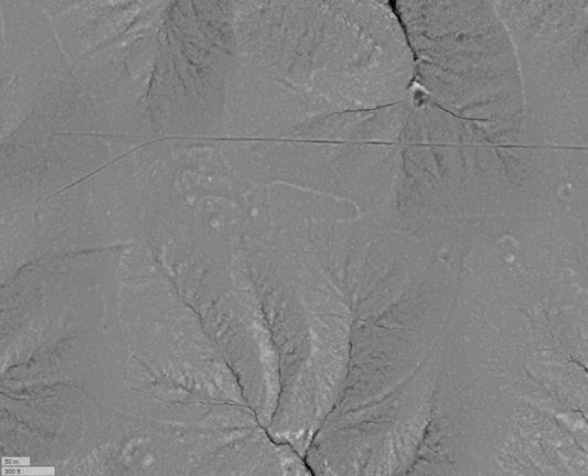
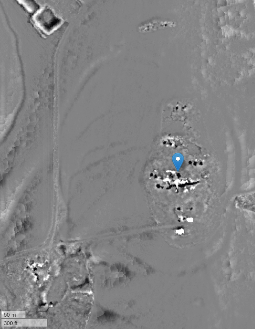
#archaeology #landscape #visualization from #lidar - 15th in a series, and my 12th post on #ChacoanBeltRoads.
This belt road is on #UteMountainUte tribal lands as as far as I know has never been documented.
We're approaching the end of this series on, so perhaps now it is time to ask the question - what are these things? The first observation we can make is that they are not pan-Chacoan. No belt roads have been found on sites in #ChacoCanyon itself
#archaeology #landscape #visualization #lidar #chacoanbeltroads #utemountainute #chacocanyon #archaeologylandscapevisualization
Matthew Bandy · @inti
147 followers · 136 posts · Server archaeo.social
#archaeology #landscape #visualization from #lidar - 14th in a series, and my 11th post on #ChacoanBeltRoads.
This is belt road is also on #MesaVerde but not on the National Park. It is on #UteMountainUte tribal lands. Note the road leading t the southeast from the architectural block at the center of the loop. The loop is mostly in pinyon/juniper woodland and is not visible at all in aerial imagery.
#archaeology #landscape #visualization #lidar #chacoanbeltroads #mesaverde #utemountainute
Matthew Bandy · @inti
146 followers · 125 posts · Server archaeo.social
#archaeology #landscape #visualization from #lidar - 13th in a series, and my 10th post on #ChacoanBeltRoads.
This is a belt road in the Badger House community on Weatherill Mesa in #MesaVerde #NationalPark in #Colorado. This one is rather faint but also quite large at 550x700 meters.
https://archive.org/details/badgerhousecommu00haye/page/2/mode/2up
#archaeology #landscape #visualization #lidar #chacoanbeltroads #mesaverde #nationalpark #colorado
Matthew Bandy · @inti
144 followers · 116 posts · Server archaeo.social
#archaeology #landscape #visualization from #lidar - 12th in a series, and my 9th post on #ChacoanBeltRoads.
Another site in SW #Colorado. This one is near Cottonwood Canyon on private land. The belt road has been highly disturbed by recent agriculture, and the site appears to be badly looted, likely with a backhoe.
#archaeology #landscape #visualization #lidar #chacoanbeltroads #colorado
Matthew Bandy · @inti
141 followers · 98 posts · Server archaeo.social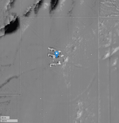
#archaeology #landscape #visualization from #lidar - 11th in a series, and my 8th post on #ChacoanBeltRoads.
Another site in SW #Colorado. Almost the last one. The road has been highly disturbed by recent agriculture, but is still mostly visible.
#archaeology #landscape #visualization #lidar #chacoanbeltroads #colorado
Matthew Bandy · @inti
140 followers · 91 posts · Server archaeo.social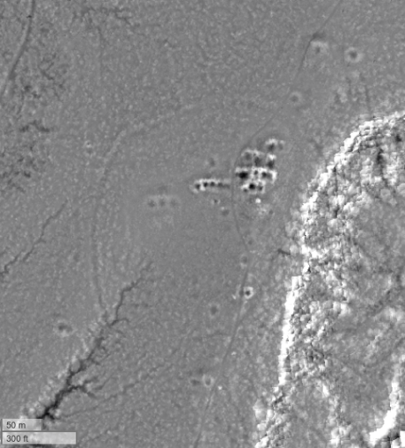
#archaeology #landscape #visualization from #lidar - 10th in a series, and my 7th post on #ChacoanBeltRoads.
Like the previous site, this is located near Woods Canyon in SW #Colorado. I haven't visited this site either. It's a little smaller than the previous one and the belt road is a little more faint. This one hasn't been disturbed by recent agriculture.
#archaeology #landscape #visualization #lidar #chacoanbeltroads #colorado
Matthew Bandy · @inti
137 followers · 84 posts · Server archaeo.social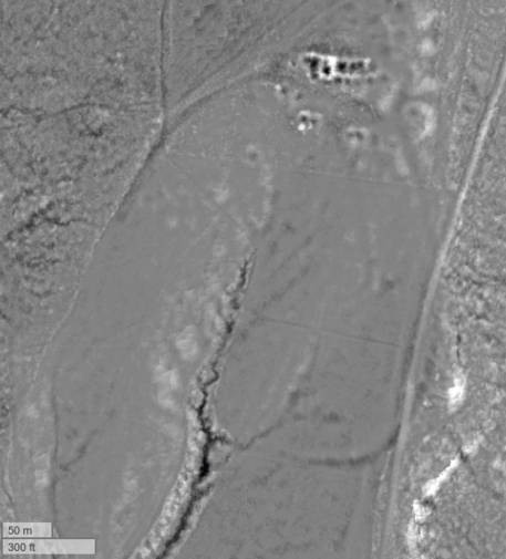
#archaeology #landscape #visualization from #lidar - 9th in a series, and my 6th post on #ChacoanBeltRoads.
This is a large site in the Great Sage Plain of SW #Colorado. I actually don't know the name of this site. As at Lowry Ruin, the principal architectural block is at the North end of the belt road. In this case the road has been affected by modern agriculture, but is still visible in the local relief visualization. See aerial imagery in comments.
#archaeology #landscape #visualization #lidar #chacoanbeltroads #colorado
Matthew Bandy · @inti
135 followers · 81 posts · Server archaeo.social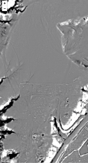
#archaeology #landscape #visualization from #lidar - 8th in a series, and my 5th post on #ChacoanBeltRoads.
This is the site of Morris 39 in the La Plata valley of NW #NewMexico. The site is poorly known and heavily impacted by a residential development. The belt road is clear, however, though it has been partially destroyed. In this case, it is somewhat to the North of the main ruins and the largest roomblocks.
#archaeology #landscape #visualization #lidar #chacoanbeltroads #newmexico
Matthew Bandy · @inti
132 followers · 77 posts · Server archaeo.social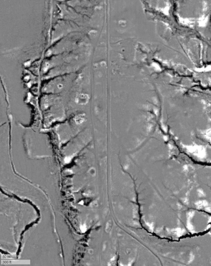
#archaeology #landscape #visualization from #lidar - 7th in a series, and my fourth post on #ChacoanBeltRoads. This is the Holmes Group in the La Plata valley of northwestern #NewMexico. This is the clearest and most perfectly round belt road I've seen.
https://www.archaeologicalconservancy.org/help-save-chaco-outlier-meet-holmes-group-site/
#archaeology #landscape #visualization #lidar #chacoanbeltroads #newmexico

Matthew Bandy · @inti
125 followers · 72 posts · Server archaeo.social
#archaeology #landscape #visualization from #lidar - sixth in a series, and my third post on #ChacoanBeltRoads. This is the Far View group in #MesaVerdeNationalPark in #Colorado. It has a clear belt road as well as a linear road leading south to the Spruce Tree House ruin, or which the very northern portion is visible here.
https://www.nps.gov/meve/learn/historyculture/mt_far_view_sites.htm
#archaeology #landscape #visualization #lidar #chacoanbeltroads #mesaverdenationalpark #colorado
Matthew Bandy · @inti
114 followers · 59 posts · Server archaeo.social
.. and here it is with the roads annotated