
· @Amor_plantonico
2 followers · 1181 posts · Server toot.communityRT @SatelliteSci
The slow advance of sand around Double Island Point (south-east Queensland), near the end of its multi-million-year journey northwards before disappearing into the abyss at the tip of K'gari / Fraser Island...
#DigitalEarthAU @CopernicusEU #Sentinel2 satellite data, 2015-2023

Alex Leith · @alexgleith
171 followers · 92 posts · Server mapstodon.spacePretty fantastic! Nice to see the @sentinel_hub cloudless model being applied here too, a sensible choice!
---
RT @GeoscienceAus
Press ▶️ and compare the pair!
📽️ #1 - noisy, cloudy Level 1C #Sentinel2 data over Seaham, NSW
VS
📽️ #2 - #DigitalEarthAU's #Sentinel2 ARD processing vastly improves accuracy and consistency over time
Explore the data yourself 👉 https://bit.ly/3ZdVyjG https://twitter.com/i/web/status/1641314671277002752
https://twitter.com/GeoscienceAus/status/1641314671277002752

Chuixiang (Tree) Yi · @TreeYi
9 followers · 3344 posts · Server mastodon.worldRT @SatelliteSci
Yesterday morning, the powers of @NASA_Landsat and @CopernicusEU #Sentinel2 combined to produce this incredible snapshot of flooding across Australia's Gulf of Carpentaria.🛰️📸
This false colour animation covers a distance of over 1000 km!
https://maps.dea.ga.gov.au/#share=s-dnb73Z7reghChXihb3J44jlyg4y #DigitalEarthAU

Robbi Bishop-Taylor · @SatelliteSci
554 followers · 43 posts · Server mapstodon.spaceVersion 2.0 of Geoscience Australia's #DEACoastlines coastal change dataset is available now!
This update includes lots of exciting new improvements:
🌊 Brand new annual shoreline data for 2021
🏝️ Extra coverage of remote islands and reefs
⚠️ Improved quality data flags for each individual shoreline and rates of change
🛰️ Now includes #Landsat9 satellite data and a new global tide model
More information and important links in the #DigitalEarthAU story here!
https://www.dea.ga.gov.au/news/dea-coastlines-2-now-available
#deacoastlines #landsat9 #digitalearthau
Chuixiang (Tree) Yi · @TreeYi
9 followers · 2424 posts · Server mastodon.world
RT @SatelliteSci
Couldn't be more excited about this major #DigitalEarthAU update: a brand new #Sentinel2 satellite data collection for Australia!
Too many improvements to fit in a single tweet - see the 🧵 below for some of the biggest highlights! https://twitter.com/GeoscienceAus/status/1620632976735494147
Robbi Bishop-Taylor · @SatelliteSci
535 followers · 42 posts · Server mapstodon.space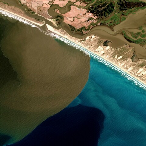
An incredible satellite view of the Murray River flood plume - thick turbid water pushing up against milky coastal and darker ocean waters offshore of the Murray Mouth in South Australia's Coorong region.
Some amazing flow dynamics along the lower river channel river as well!
@CopernicusEU #Sentinel2 imagery from 6th January 2023 processed by #DigitalEarthAU:
https://maps.dea.ga.gov.au/#share=s-A8KyZmwuWnCRrynmsTBbHJbSss1
Robbi Bishop-Taylor · @SatelliteSci
482 followers · 29 posts · Server mapstodon.spaceFinishing the year with some beautiful satellite imagery: three decades of spectacular subtidal dynamics at the southern tip of Moreton Island in south-east Queensland, driven by the slow drift of sand northward along Australia's east coast.
USGS/NASA #Landsat 5, 7 and 8 satellite data from the #DigitalEarthAU datacube :opendatacube:
Robbi Bishop-Taylor · @SatelliteSci
384 followers · 21 posts · Server mapstodon.space@Axman6 @bmedlyn Yep! We have our own #DigitalEarthAU Terria map that serves as a simpler version of National Map containing just our DEA satellite datasets and products 🙂
Robbi Bishop-Taylor · @SatelliteSci
284 followers · 1 posts · Server mapstodon.spaceA mind-blowing transformation from drought to flood across the Ramsar listed Macquarie Marshes and Macquarie-Barwon floodplain in south-eastern Australia over the past three years:
@CopernicusEU #Sentinel2 false colour imagery from Nov 19 2019 vs Nov 18 2022.
https://maps.dea.ga.gov.au/#share=s-t6eraPVsznm1M51uID9DE3fQA68 #DigitalEarthAU
Robbi Bishop-Taylor · @SatelliteSci
284 followers · 1 posts · Server mapstodon.spaceA mind-blowing transformation from drought to flood across the Ramsar-listed Macquarie Marshes and Macquarie-Barwon floodplain in south-eastern Australia over the past three years:
@CopernicusEU #Sentinel2 false colour imagery from Nov 19 2019 vs Nov 18 2022
https://maps.dea.ga.gov.au/#share=s-t6eraPVsznm1M51uID9DE3fQA68 #DigitalEarthAU