Sarah Dal · @sarahdalgulls
463 followers · 3042 posts · Server ecoevo.socialKeen to follow more folk who are involved with #DroneMapping #UAVMapping #Orthomosaics #UAVs
#dronemapping #uavmapping #orthomosaics #uavs
ClearSkyImaging · @uk_csi
116 followers · 268 posts · Server mstdn.social
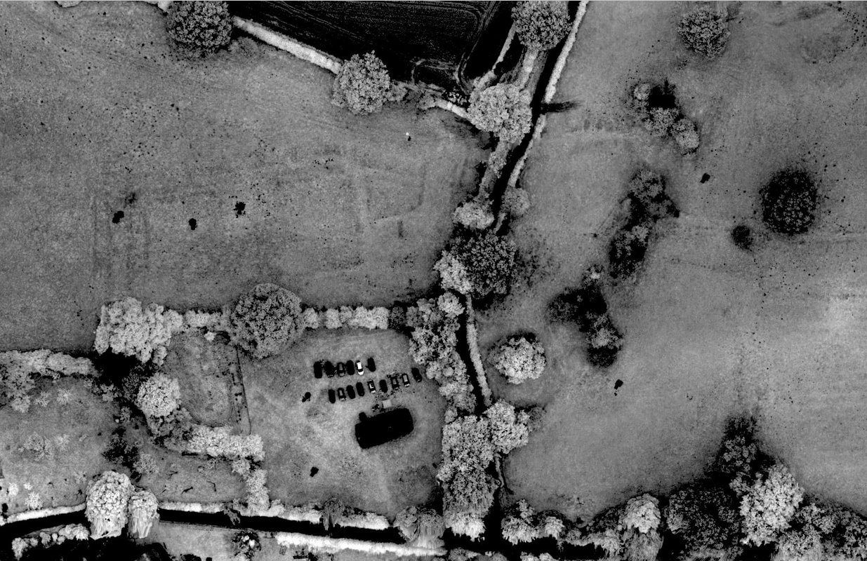
A Near Infra Red of part of the Medieval deserted village in Heath, Shropshire.
The 'black' building near the centre of the bottom of the image is the old chapel, the field above it shows the ditches from possibly an old manor house and moat.
This was from a licensed dig in 2021 the cars behind the church belonging to the volunteers.
#History #Medieval #DesertedVillage #Archeology #Shropshire #England #Drone #DroneImaging #AerialPhoto #Aerial #DroneMapping #NIR #History
#nir #dronemapping #aerial #aerialphoto #droneimaging #drone #england #shropshire #archeology #desertedvillage #medieval #History

𝑪𝒐𝒓𝒆𝒚 𝑺𝒏𝒊𝒑𝒆𝒔 🌤 · @coreysnipes
435 followers · 1453 posts · Server fosstodon.orgLooking forward to my fourth year at DroneCamp next week. This event is a joint effort by the Univ of California, CSU, and Monterey Bay DART. The presentations tend to focus on drone mapping for academics, agriculture, and conservation.
I'll be giving the workshop on ODM/WebODM and just generally helping out where I can.
#drone #drones #uav #OpenDroneMap #odm #WebODM #DroneMapping #monterey #DroneCamp #DroneCamp2023 #DroneCampCAP #DroneCampCA2023
#drone #drones #uav #opendronemap #odm #WebODM #dronemapping #monterey #dronecamp #dronecamp2023 #dronecampcap #dronecampca2023
𝑪𝒐𝒓𝒆𝒚 𝑺𝒏𝒊𝒑𝒆𝒔 🌱 · @coreysnipes
331 followers · 893 posts · Server fosstodon.orgA very nice experiment examining different overlap values for drone mapping flights, ranging from 95% to 35%.
https://www.youtube.com/watch?v=9WMTc3HH4uM
#drone #drones #dronemapping #photogrammetry #opendronemap #metashape #dronedeploy #pix4d
#drone #drones #dronemapping #photogrammetry #opendronemap #metashape #dronedeploy #pix4d

LB4FH · @lb4fh
61 followers · 46 posts · Server mastodon.radio
LB4FH · @lb4fh
60 followers · 45 posts · Server mastodon.radio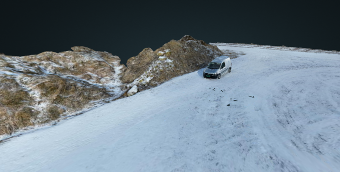
Having some fun with #dronemapping in #webODM with my DJI Mini 3 Pro drone. Fun little program
𝑪𝒐𝒓𝒆𝒚 𝑺𝒏𝒊𝒑𝒆𝒔 🌱 · @coreysnipes
305 followers · 716 posts · Server fosstodon.orgI'm selling two Emlid Reach RS single-band GNSS receivers (rover + base) on eBay if anyone is in the market for such things.
https://www.ebay.com/itm/325560657173
#gps #gnss #rtk #mapping #landsurvey #emlid #emlidreach #dronemapping
#gps #gnss #rtk #mapping #landsurvey #emlid #emlidreach #dronemapping

GregCocks · @GregCocks
135 followers · 153 posts · Server techhub.social
Good To Attend A Day At GeoWeek
--
https://www.geo-week.com/ <-- conference page
--
Excellent to attend GeoWeek for a day, interact in person with so many, see some amazing technology – and get to drive a Boston Dynamics ‘robot dog’!!
#GIS #spatial #mapping #Denver #Colorado #inperson #conference #snow #networking #3DEP #3DHP #opendata #geoweek #networking #technology #drones #dronemapping #LiDAR
#USGS #BostonDynamics
#gis #spatial #mapping #denver #colorado #inperson #conference #snow #networking #3dep #3dhp #opendata #geoweek #Technology #drones #dronemapping #lidar #usgs #bostondynamics
faine greenwood · @faineg
2456 followers · 437 posts · Server mstdn.socialSeeing a number of examples of small drones being used for search and rescue efforts in Syria and Turkey right now. Guessing drone mapping efforts of the destroyed areas will be coming next (or, I hope so).
#drone #dronemapping #syria #turkey #earthquake #disaster #humanitarianaid #humanitarian #mapping #gis
#gis #mapping #humanitarian #humanitarianaid #disaster #earthquake #turkey #Syria #dronemapping #drone
faine greenwood · @faineg
2479 followers · 474 posts · Server mstdn-social.social.shrimpcam.pwSeeing a number of examples of small drones being used for search and rescue efforts in Syria and Turkey right now. Guessing drone mapping efforts of the destroyed areas will be coming next (or, I hope so).
#drone #dronemapping #syria #turkey #earthquake #disaster #humanitarianaid #humanitarian #mapping #gis
#gis #mapping #humanitarian #humanitarianaid #disaster #earthquake #turkey #Syria #dronemapping #drone
𝑪𝒐𝒓𝒆𝒚 𝑺𝒏𝒊𝒑𝒆𝒔 🕯️❄️ · @coreysnipes
266 followers · 494 posts · Server fosstodon.org
Ran a quick #dronemapping flight of the pool rebuild project in our city park today. I'm always impressed with the level of detail available in the orthophoto and point cloud, from just 125 photos.
#opendronemap #odm #opensource #photogrammetry #sfm #dronedeploy #dji #phantom4
#dronemapping #opendronemap #odm #opensource #photogrammetry #sfm #dronedeploy #dji #phantom4

BPlanZ · @BPlanZ
124 followers · 309 posts · Server infosec.exchange
Anyone have information on drone boats that appear to be in use for mapping lakes? These boats have multiple antennas and appear to be at least semi-autonomous in operation.
We are seeing multiple craft like this one (see picture) on an East Tx lake. Multiple antennas on the back. Bright light that is on for night time operations. #drone #dronemapping #lakemapping
#drone #dronemapping #lakemapping
BPlanZ · @BPlanZ
125 followers · 323 posts · Server infosec.exchangeAnyone have information on drone boats that appear to be in use for mapping lakes? These boats have multiple antennas and appear to be at least semi-autonomous in operation.
We are seeing multiple craft like this one (see picture) on an East Tx lake. Multiple antennas on the back. Bright light that is on for night time operations. #drone #dronemapping #lakemapping
#drone #dronemapping #lakemapping
𝑪𝒐𝒓𝒆𝒚 𝑺𝒏𝒊𝒑𝒆𝒔 🕯️❄️ · @coreysnipes
224 followers · 364 posts · Server fosstodon.org
#DroneMapping and #ODM people! I made some #OpenDroneMap stickers. DM me your address and I will mail you a couple. All I ask is that you share a photo once you receive them.
International OK! I have mailed them to Tromsø Norway, Sao Paolo Brazil, Bangalore India, and Ghana.
(boosts appreciated)
#dronemapping #odm #opendronemap
ClearSkyImaging · @uk_csi
81 followers · 96 posts · Server mstdn.social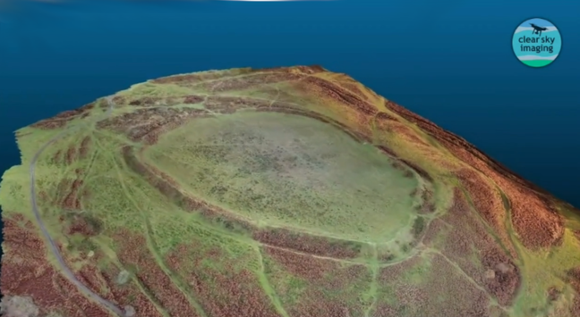
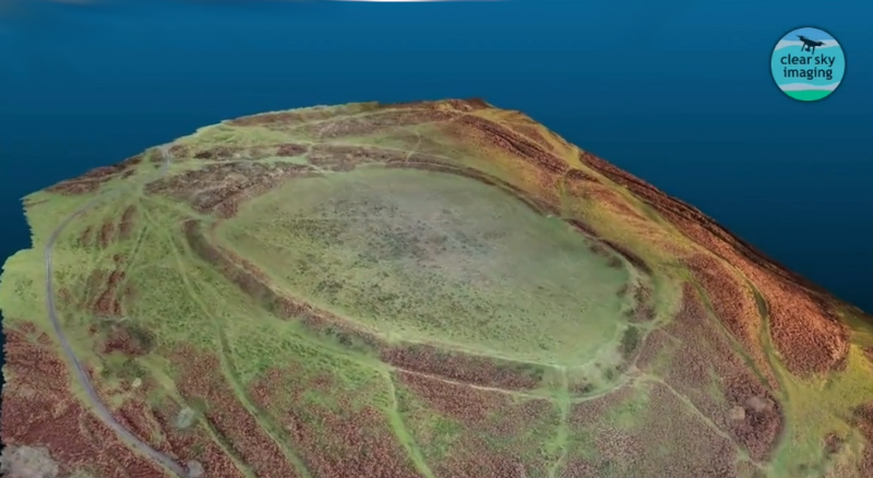
For those who were interested in our aerial image of Nordy Bank HillFort we recently shared.
We also made a '3d Model', again using OpenDroneMap, and from that, produced a 'flyby video'
#drone #DroneMapping #Photogrammetry ##AerialMapping #3dModel #HillFort #Shropshire #UK #IronAge #OpenDroneMap
#opendronemap #ironage #UK #shropshire #hillfort #3dmodel #aerialmapping #photogrammetry #dronemapping #drone
ClearSkyImaging · @uk_csi
90 followers · 141 posts · Server mstdn.socialFor those who were interested in our aerial image of Nordy Bank HillFort we recently shared.
We also made a '3d Model', again using OpenDroneMap, and from that, produced a 'flyby video'
#drone #DroneMapping #Photogrammetry ##AerialMapping #3dModel #HillFort #Shropshire #UK #IronAge #OpenDroneMap
#opendronemap #ironage #UK #shropshire #hillfort #3dmodel #aerialmapping #photogrammetry #dronemapping #drone
ClearSkyImaging · @uk_csi
75 followers · 95 posts · Server mstdn.social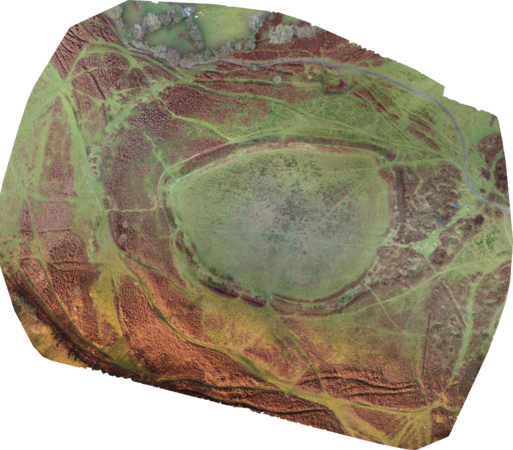
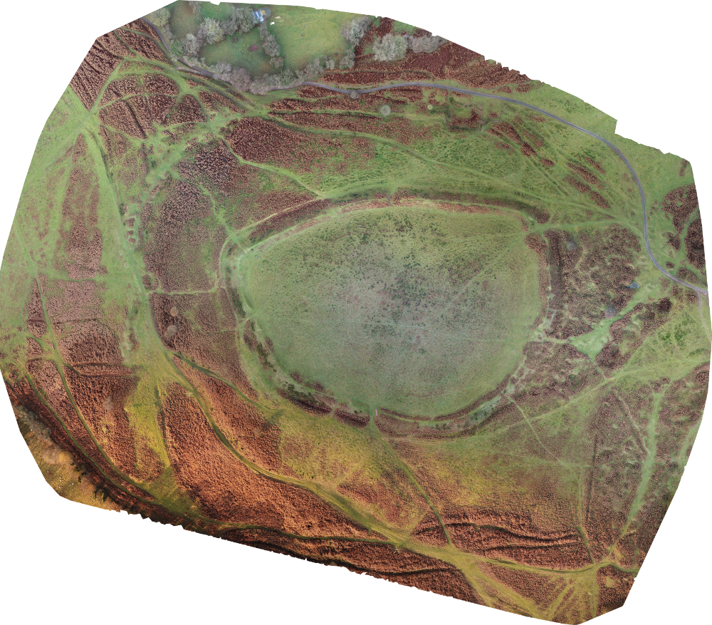
Nordy Bank is a univallate hillfort on the flanks of Brown Clee Hill, the highest hill in Shropshire.
Here's a composite of some 540+ drone photos, mostly from a P4Pro, but some from a Mavic Pro, all stitched together using OpenDroneMap of the hillfort and it's environs.
OpenDroneMap handled the 2 sets of images from 2 different drones effortlessly!
#HillFortWednesday #Shropshire #Drone #DroneMapping #uk #CleeHills #AerialMapping #DronePhotograhy #HillFort #OpenDroneMap
#opendronemap #hillfort #dronephotograhy #aerialmapping #cleehills #UK #dronemapping #drone #shropshire #hillfortwednesday
ClearSkyImaging · @uk_csi
90 followers · 141 posts · Server mstdn.socialNordy Bank is a univallate hillfort on the flanks of Brown Clee Hill, the highest hill in Shropshire.
Here's a composite of some 540+ drone photos, mostly from a P4Pro, but some from a Mavic Pro, all stitched together using OpenDroneMap of the hillfort and it's environs.
OpenDroneMap handled the 2 sets of images from 2 different drones effortlessly!
#HillFortWednesday #Shropshire #Drone #DroneMapping #uk #CleeHills #AerialMapping #DronePhotograhy #HillFort #OpenDroneMap
#opendronemap #hillfort #dronephotograhy #aerialmapping #cleehills #UK #dronemapping #drone #shropshire #hillfortwednesday
ClearSkyImaging · @uk_csi
64 followers · 72 posts · Server mstdn.social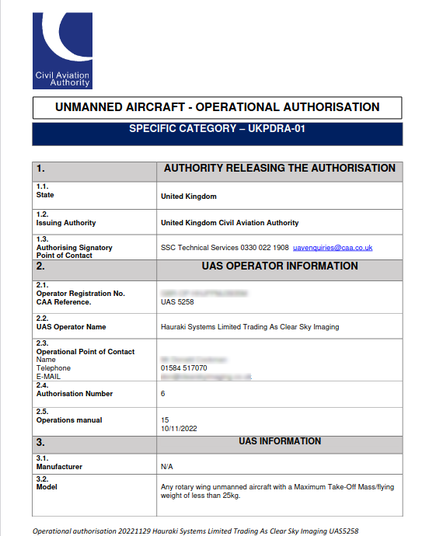
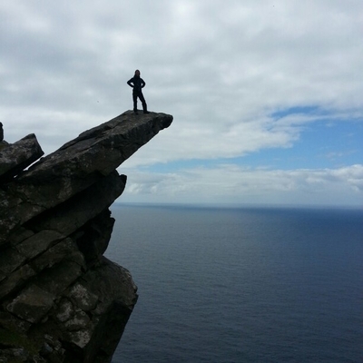
Nice to have our CAA Operational Authorisation renewed for another year. Looking forward to doing lots more aerial photos, videos and data collecting! (without breaking any any more bones... 😲 )
#drone #dronemapping #dronephotography #dronevideo
#dronevideo #dronephotography #dronemapping #drone
ClearSkyImaging · @uk_csi
90 followers · 141 posts · Server mstdn.socialNice to have our CAA Operational Authorisation renewed for another year. Looking forward to doing lots more aerial photos, videos and data collecting! (without breaking any more bones... 😲 )
#drone #dronemapping #dronephotography #dronevideo
#dronevideo #dronephotography #dronemapping #drone