
Theta · @theta
8 followers · 17 posts · Server fosstodon.org
Free downloads for iOS and Android are available through links at our website, https://theta.limited.
To get directly in touch with our developers, please email:
support@theta.limited
,with subject "Maui Wildfire Recovery". Support services provided gratis.
#mauifires #mauiwildfires #dronesforgood #publicsafety #disasterrecovery #gis #dronetechnology #dronephotography
#mauifires #mauiwildfires #dronesforgood #publicsafety #disasterrecovery #gis #dronetechnology #dronephotography
Theta · @theta
8 followers · 15 posts · Server fosstodon.orgTheta Informatics stands ready to assist with Maui Wildfire recovery efforts.
Our free software, #OpenAthena for Android, allows a precise ground location to be obtained from any point in an image taken by common #drones. This may be useful for quickly marking damaged buildings, structures, and infrastructure from aerial images taken by drones.
#Maui #mauifires #mauiwildfires #dronesforgood #publicsafety #disasterrecovery #gis #dronetechnology #dronephotography
#openathena #drones #maui #mauifires #mauiwildfires #dronesforgood #publicsafety #disasterrecovery #gis #dronetechnology #dronephotography

ClearSkyImaging · @uk_csi
98 followers · 177 posts · Server mstdn.social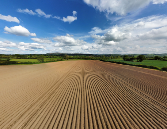
Hopefully not too long until the sun's out and it warms up a bit.
We potentially have a few agricultural trials to visit and document.
#Drone #DronesForAgriculture #DronesForGood #Agriculture #Farm #DronepPhoto #AerialPhotography #DronePhotography #Countryside #Landscape #Photography #Shropshire #England #UK #WelshMarches
#welshmarches #UK #england #shropshire #Photography #Landscape #countryside #dronephotography #aerialPhotography #dronepphoto #farm #agriculture #dronesforgood #dronesforagriculture #drone

GregCocks · @GregCocks
209 followers · 265 posts · Server techhub.social
First Responder UAS 3D Mapping Challenge (UAS 5.0)
--
https://www.challenge.gov/?challenge=uas5 challenge details
--
https://firstresponderuaschallenge.org/uas5/ <-- application page
--
[total cash prizes of ~ $1,000,000; note that I have ZERO involvement with this challenge]
#GIS #spatial #mapping #indoors #UAS #drones #drone #dronesforgood #dronesurvey #dronesurveying #emergencyresponse #firstresponders #firefighting #firefightingequipment #challenge #competition #gischat #infrastructure #design #people #safety #buildings #survey #response #3D #3dmodeling #3dscanning #3dmapping #aerialsurvey #buildinginspection
#gis #spatial #mapping #indoors #uas #drones #drone #dronesforgood #dronesurvey #dronesurveying #emergencyresponse #firstresponders #firefighting #firefightingequipment #challenge #competition #gischat #infrastructure #Design #people #safety #buildings #survey #response #3d #3dmodeling #3dscanning #3dmapping #aerialsurvey #buildinginspection

Lincsdrones · @Lincsdrones
0 followers · 1 posts · Server mastodon.lolTime to build new #network just incase the bluebird flies #buildingnetworkfriday
#lincsdrones #dronesUK #Lincolnshire #Dronesforgood #dronesar
#network #buildingnetworkfriday #lincsdrones #dronesuk #lincolnshire #dronesforgood #dronesar
Gary Mortimer · @GaryMortimer
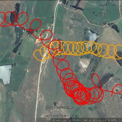
25 followers · 272 posts · Server mastodon.worldRT @LincsCOPter
Drone finds Missing Person in #Lincoln. The white spot in the centre of the thermal video is a Missing Person. Viewing daylight footage this person can’t be seen but the #drones #thermal detects body heat. @LincsPolice officers guided in. #dronesforgood Inc 248 13/11/22
#lincoln #drones #Thermal #dronesforgood

MapAm💜re · @MapAmore
523 followers · 1021 posts · Server en.osm.townRT @Tech4PR
Here is the link to the event. https://m.youtube.com/watch?feature=share&v=TwXSQnlOohs
You may visit https://pistangmapa.github.io/2020/
for more information.
#openstreetmap #PnM20 #foss4g #freeconference #opensource #drones #dronesforgood
#foss4g #OpenStreetMap #PnM20 #freeconference #opensource #drones #dronesforgood