
BC Info Bot · @bcinfo
557 followers · 40000 posts · Server mastodon.roitsystems.caGlobal News BC: Highway 3 closed near Osoyoos as planned ignitions for Eagle Bluff wildfire get underway https://globalnews.ca/news/9876150/highway-3-closed-near-osoyoos-as-planned-ignitions-for-eagle-bluff-wildfire-get-underway/ #globalnews #britishcolumbia #news #EagleBluffWildfire #OKANAGANWILDFIRES #highway3closure #EagleBluffFire #southokanagan #BCwildfires #Highway3 #Okanagan #drivebc #osoyoos #Fire
#globalnews #BritishColumbia #news #eaglebluffwildfire #okanaganwildfires #highway3closure #eagleblufffire #southokanagan #BCwildfires #Highway3 #okanagan #drivebc #osoyoos #fire
BC Info Bot · @bcinfo
548 followers · 39551 posts · Server mastodon.roitsystems.caGlobal News BC: As Osoyoos residents return home, attention remains on weather and winds https://globalnews.ca/news/9869631/bc-wildfire-tuesday-august-1/ #globalnews #britishcolumbia #news #BCWildfireweather #YearlingCreekfire #BCwildfirelatest #bcwildfirestatus #BCwildfirestoday #EagleBluffFire #Osoyoosfire #BCWildfire #Fire
#globalnews #BritishColumbia #news #bcwildfireweather #yearlingcreekfire #bcwildfirelatest #bcwildfirestatus #bcwildfirestoday #eagleblufffire #osoyoosfire #BCWildfire #fire

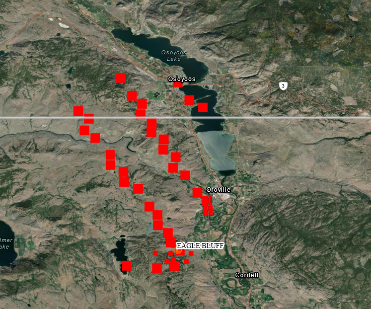
Joseph Elfelt · @mappingsupport
417 followers · 307 posts · Server m.ai6yr.org
July 31 morning. Interactive #GIS map shows MODIS and VIIRS satellite *heat* detection for #EagleBluffFire near #Oroville WA and #Osoyoos BC.
Apparently no infrared flight last night.
Pink area on USA side is clickable and at time of my post shows 9,743 acres as of Saturday evening.
#WAfire #WAwx #BCfire #wildfire #Geospatial #Maps #Mapping #Leaflet #ArcGIS #WebMap
Open #GISsurfer map: https://bit.ly/43OfN8X
#gis #eagleblufffire #oroville #osoyoos #wafire #wawx #bcfire #Wildfire #geospatial #maps #mapping #leaflet #arcgis #webmap #gissurfer
Joseph Elfelt · @mappingsupport
417 followers · 307 posts · Server m.ai6yr.org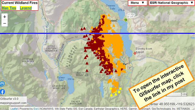
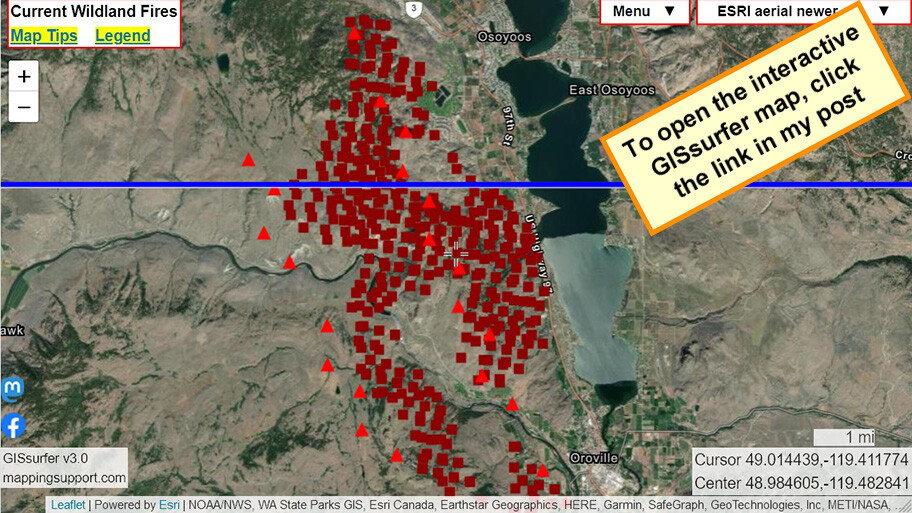
July 30 evening. Interactive #GIS map shows MODIS and VIIRS satellite *heat* detection for #EagleBluffFire near #Oroville WA and #Osoyoos BC.
If there is an infrared flight tonight then I will post a map with that data early tomorrow.
#WAfire #WAwx #BCfire #wildfire #Geospatial #Maps #Mapping #Leaflet #ArcGIS #WebMap
Open #GISsurfer map:
https://mappingsupport.com/p2/gissurfer.php?center=48.955199,-119.532623&zoom=11&basemap=ESRI_National_Geographic&overlay=VIIRS_7_day,MODIS_7_day,State_boundary,Wind_temperature_and_more...&data=https://mappingsupport.com/p2/special_maps/disaster/USA_wildland_fire.txt
#gis #eagleblufffire #oroville #osoyoos #wafire #wawx #bcfire #Wildfire #geospatial #maps #mapping #leaflet #arcgis #webmap #gissurfer

MiBaWi - Michael Barthel · @MiBaWi
351 followers · 1051 posts · Server m.ai6yr.org
No drones today, BUT ..... Seriously !??
Get your asses out of the lake !! You hinder the extinguishing work, and these are also life-threatening actions !!
📸Osoyoos Connect Facebook Page
#osoyoos #osoyooslake #eagleblufffire
MiBaWi - Michael Barthel · @MiBaWi
351 followers · 1050 posts · Server m.ai6yr.org
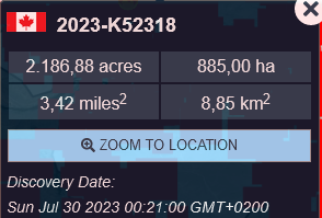
#EagleBluffFire has been mapped at 11,932 acres [4,828 ha]
9,745 acres in the United States 2,187 acres in Canada
(07/30/2023 - 11:21am)
MiBaWi - Michael Barthel · @MiBaWi
350 followers · 1049 posts · Server m.ai6yr.org
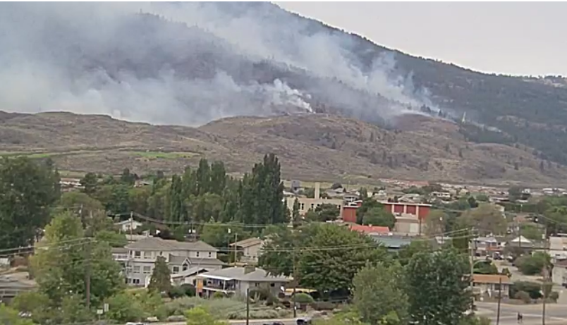
#EagleBluffFire view via the Holiday Inn #Osoyoos live cam >
https://globalnews.ca/okanagan/live-cameras/scenic/holiday-inn-osoyoos/
Joseph Elfelt · @mappingsupport
413 followers · 301 posts · Server m.ai6yr.org
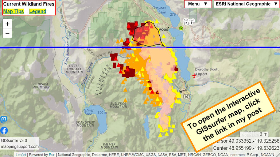
July 30 morning. Interactive #GIS map shows MODIS and VIIRS satellite *heat* detection for #EagleBluffFire near #Oroville WA and #Osoyoos BC.
Detection data is not real time, locations only approximate and sometimes ‘false positive’. To learn more, click “Map tips” in upper left corner and read about MODIS/VIIRS.
#WAfire #WAwx #BCfire #wildfire #Geospatial #Maps #Mapping #Leaflet #ArcGIS #WebMap
Open #GISsurfer map:
https://mappingsupport.com/p2/gissurfer.php?center=48.984605,-119.482841&zoom=12&basemap=ESRI_aerial_newer&overlay=VIIRS_7_day,MODIS_7_day,State_boundary&data=https://mappingsupport.com/p2/special_maps/disaster/USA_wildland_fire.txt
#gis #eagleblufffire #oroville #osoyoos #wafire #wawx #bcfire #Wildfire #geospatial #maps #mapping #leaflet #arcgis #webmap #gissurfer
MiBaWi - Michael Barthel · @MiBaWi
350 followers · 1049 posts · Server m.ai6yr.org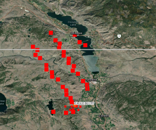
#EagleBluffFire #Oroville / #Osoyoos
FIRMS US/CANADA Wildfire Map > https://firms.modaps.eosdis.nasa.gov/usfs/map/#d:24hrs;@-119.4,49.0,12z
#eagleblufffire #oroville #osoyoos
MiBaWi - Michael Barthel · @MiBaWi
351 followers · 1045 posts · Server m.ai6yr.org#EagleBluffFire #Oroville #OkanoganCounty #Washington - Evacuation Center / Shelter
Red Cross Shelter:
Oroville High School, 1016 Ironwood St, Oroville, WA 98844, Call 206-450-8564
Animal Shelter:
Tonasket Rodeo Grounds, 12 Rodeo Rd, Tonasket, WA 98855
#eagleblufffire #oroville #okanogancounty #washington
MiBaWi - Michael Barthel · @MiBaWi
351 followers · 1045 posts · Server m.ai6yr.orgThe #LonePineCreekFire ( #Canada ) has been re-named to #EagleBluffFire ( #UnitedStates ) in coordination with US Forest Services
An ESS Reception Centre for evacuees on the Canadian side of the border has been opened at the Oliver Community Centre:
> 6359 Park Dr., #Oliver, #BritishColumbia, #Canada
Please visit the reception if you require supports.
#lonepinecreekfire #canada #eagleblufffire #unitedstates #oliver #BritishColumbia
MiBaWi - Michael Barthel · @MiBaWi
351 followers · 1045 posts · Server m.ai6yr.org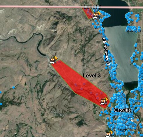
The #LonePineCreekFire ( #Canada ) aka the #EagleBluffFire ( #UnitedStates ) has forced evacuations on both sides of the border.
#lonepinecreekfire #canada #eagleblufffire #unitedstates
MiBaWi - Michael Barthel · @MiBaWi
350 followers · 1042 posts · Server m.ai6yr.org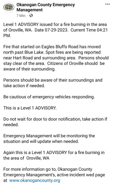
#EagleBluffFire > 239 Eagles Bluff Rd, #Oroville, #OkanoganCounty / #Washington
Level 1 > If you feel unsafe, do not wait for evacuation orders .
Evacuation updates
https://www.facebook.com/Okanogan.County.Emergency.Management
Cam
https://www.alertwildfire.org/region/oregon/?camera=Axis-Aeneas
Watch Duty
https://app.watchduty.org/i/8613#allow-back
#eagleblufffire #oroville #okanogancounty #washington