
Fiona Gregory · @fionag11
46 followers · 165 posts · Server mapstodon.space5/5 And here's my script that does those three things - find all Sentinel-2 images that completely cover an AOI without clouds, and export them in batch #EarthEngine
https://code.earthengine.google.com/29d73d3ef57735514ebaceb5aeae0b75
(It also pages through the thumbnails so you can inspect them visually!)
Fiona Gregory · @fionag11
46 followers · 164 posts · Server mapstodon.space4/5 3) How to export an image collection in batch (Thanks Rodrigo Principe author of geetools)! https://gis.stackexchange.com/questions/248216/exporting-each-image-from-collection-in-google-earth-engine/248230#248230
#EarthEngine
Fiona Gregory · @fionag11
46 followers · 163 posts · Server mapstodon.space3/5 2) How to find which images are cloudfree over your area of interest, rather than the entire image (Thanks Blue101black!) https://gis.stackexchange.com/questions/375261/how-can-filter-low-cloud-coverange-in-a-region-with-sentinel-2-l2a-in-gee/376759#376759
#EarthEngine
Fiona Gregory · @fionag11
46 followers · 161 posts · Server mapstodon.spaceSpeaking for myself, there is no coding without StackExchange, and this especially goes for javascript for #EarthEngine!

Marten Winter · @sMarten_Winter
431 followers · 302 posts · Server ecoevo.social
Using building density 👇 for refining analyses of drivers of urban biodiversity seems to be meaningful approach
---
RT @spatialthoughts
Built a script today to create a building density map for anywhere in the world using Google #EarthEngine and the @Microsoft Global ML Building Footprints dataset from the GEE Community Catalog. Try out the script on your own region of interest https://code.earthengine.google.co.in/2c60034b74ad74cb…
https://twitter.com/spatialthoughts/status/1642862571849142272
Fiona Gregory · @fionag11
41 followers · 134 posts · Server mapstodon.space#EarthEngine users, do you know about this book https://www.eefabook.org/ and video series? https://www.eefabook.org/videos.html
Highly recommend. #eefabook

Samapriya Roy · @samapriya
36 followers · 7 posts · Server mapstodon.spaceGreat news for the @google Earth Engine community catalog with updated CMIP6 North America dataset from @adaptwest v7.3 now with 20 and 30-year ensemble models & Shoreline datasets from @GeoscienceAus and @DEarthAfrica
Share & like the GitHub project for more updates
https://github.com/samapriya/awesome-gee-community-datasets
Amazing users support open communities. Sponsor, share, and spread the project
https://gee-community-catalog.org/
#opensource #opendata #EarthEngine #GEE #ClimateChange #climate #ocean #geospatial
#opensource #opendata #earthengine #GEE #ClimateChange #Climate #ocean #geospatial
Fiona Gregory · @fionag11
36 followers · 65 posts · Server mapstodon.spaceImportant: If you are or are planning to use Sentinel-3 data on Google Earth Engine you should be aware of the data issues flagged here https://issuetracker.google.com/issues/257249154?pli=1 #EarthEngine #Sentinel3
Fiona Gregory · @fionag11
32 followers · 51 posts · Server mapstodon.space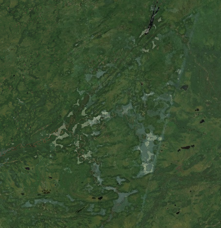
Our analysis has confirmed the importance of using the S2_HARMONIZED or S2_SR_HARMONIZED collections if you are working with imagery before and after Jan 2022. If you do not, you WILL have artifacts in your imagery/analysis.
Please spread the word, this has been underreported. #EarthEngine #Sentinel2

Frederik Kratzert · @kratzert
202 followers · 86 posts · Server sigmoid.socialAll forcing data and attributes in Caravan were derived on #Google #EarthEngine, making it feasible for everyone to add new basins to Caravan, with the only requirement to have the basin polygon(s) and stream record(s). All other data is derived in the cloud and brought into a consistent format with the code that is provided as part of the paper https://github.com/kratzert/Caravan/
First community extension was already added and hopefully more to come.

Greg Fiske · @g_fiske
512 followers · 36 posts · Server mapstodon.spaceIt only takes a few lines of code in #EarthEngine to dig up some GFS data and watch the cold plow through New England. 🥶 #wx
https://code.earthengine.google.com/ec009fb8db16f2ac0f3a6a58609209ea
Samapriya Roy · @samapriya
35 followers · 6 posts · Server mapstodon.spaceJoin me this week for a step-by-step setup guide on connecting personal Google Cloud projects to university accounts and demystifying common concepts related to Google Cloud projects and Google Earth Engine.
#GoogleCloudProjects #EarthEngine #Technology #tutorials #guide #university
#googlecloudprojects #earthengine #technology #tutorials #guide #university
Samapriya Roy · @samapriya
30 followers · 5 posts · Server mapstodon.spaceJust added the Global Long-term Microwave Vegetation Optical Depth Climate Archive (VODCA) to the #Google #EarthEngine community catalog, ensuring readiness for use in Google #EarthEngine.
Additionally, thanks to the RADD team, continuously updated RADD forest disturbance alerts are now available in the community catalog.
Changelog
https://bit.ly/awesome-gee-changelog
Sponsor, support, star & share⭐ the project
https://github.com/samapriya/awesome-gee-community-datasets
#geospatial #remotesensing #opensource #opendata #openaccess #forest
#google #earthengine #geospatial #remotesensing #opensource #opendata #openaccess #forest

Jerry Lee · @yesonline
27 followers · 9774 posts · Server mastodon.socialRT @giswqs: How to search and visualize #EarthEngine datasets using #geemap with just a few clicks?
Docs: https://t.co/7XbnSm2zbE
GitHub: https://t.co/IPq3pQgnCU
#geospatial #dataviz #geopython #opensource https://t.co/RMwl6DYzz0
#earthengine #geemap #geospatial #dataviz #GeoPython #opensource
Samapriya Roy · @samapriya
28 followers · 4 posts · Server mapstodon.spaceI recently made a useful addition to my #GEE code which allows me to see when it was last run in local time while ingesting data in the community catalog
You can try it yourself. I am channeling @Keiko_geo #EarthEngine tips series 😀
https://code.earthengine.google.com/79a474f67640936683b47f1989cf3ece
#GEE #earthengine #GoogleEarthEngine #gischat

Justin Stewart · @thecrobe
739 followers · 478 posts · Server ecoevo.socialRT @giswqs@twitter.com
#Leafmap new feature - Searching and visualizing open #geospatial datasets (#STAC) interactively without coding. It will support #AWS Open Data, #EarthEngine, #PlanetaryComputer, NASA CMR, STAC Index.
Leafmap: https://github.com/giswqs/leafmap/pull/340
Data catalogs: https://github.com/giswqs/geospatial-data-catalogs
#leafmap #geospatial #stac #aws #earthengine #PlanetaryComputer

Ingmar Nitze · @i_nitze
117 followers · 139 posts · Server mapstodon.space@samapriya Welcome. Looking forward to all the progress in your #Earthengine community catalog 😁.

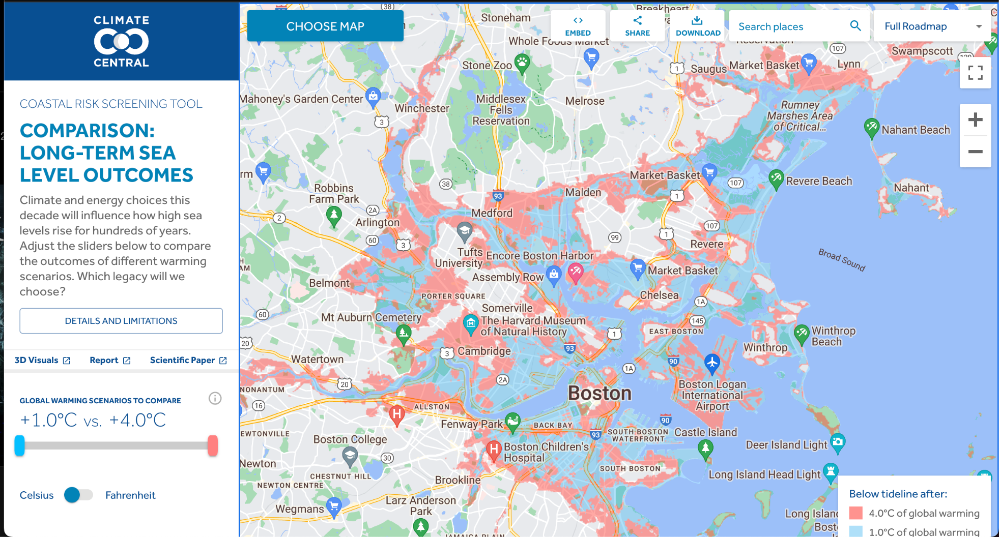
alex yuletide · @yuletide
177 followers · 284 posts · Server mastodon.social
Maps like this make me really want to dig into #earthengine.
Great work from Climate Central team, they've built a whole set of visualizations to communicate climate impacts broadly and locally
#earthengine #climatechange #maps #gischat
Justin Stewart · @thecrobe
722 followers · 364 posts · Server ecoevo.social
RT @ZZMitch@twitter.com
Wow, just came across this dataset on #EarthEngine, seems like a game changer for historic land change monitoring?
Google Global Landsat-based #CCDC Segments
https://developers.google.com/earth-engine/datasets/catalog/GOOGLE_GLOBAL_CCDC_V1
From 1999-2020 for now... will need to explore!

Jorge Cornejo :lah: :zac: · @xchido
4 followers · 5 posts · Server ataricafe.com#FOSS #Geospatial emojis added
#ArcGIS :arcgis:
#cog :cog:
#gdal :gdal:
#GoogleEarth :gearth:
#EarthEngine :gearth_engine:
#geopandas :geopandas:
#GRASSGIS :grassgis:
#NumPy :numpy:
#osgeo :osgeo:
#OpenStreetMap :osm:
#pandas :pandas:
#PostGIS :postgis:
#Postgres :postgres:
#QGIS :qgis:
#RStats :rstat:
#SAGAGIS :saga:
#arcgis #cog #gdal #googleearth #earthengine #geopandas #grassgis #numpy #osgeo #openstreetmap #pandas #postgis #postgres #qgis #rstats #foss #geospatial #sagagis