
GregCocks · @GregCocks
682 followers · 566 posts · Server techhub.social
Coastal Storm Modeling System (CoSMoS) [USGS]
--
https://www.usgs.gov/centers/pcmsc/science/coastal-storm-modeling-system-cosmos <-- project web page
--
H/T @Anthro #GIS #spatial #mapping #coastal #storm #modeling #CoSMoS #model #spatialanalysis #extremeweather #spatialanalysis #spatiotemporal #prediction #hindcast #mitigation #planning #climate #climatechange #naturalhazard #emergencyresponse #emergencypreparedness #emergencymanagement #risk #hazard #publicsafety #stormdamage #stormsurge #stormpreparedness #flood #flooding #coastalflooding #remotesensing #hydrospatial #water #hydrology #hydrography #topobathy #SLR #sealevelrise #urbanplanning
#gis #spatial #mapping #coastal #storm #modeling #cosmos #model #spatialanalysis #extremeweather #spatiotemporal #prediction #hindcast #mitigation #planning #climate #climatechange #naturalhazard #emergencyresponse #emergencypreparedness #emergencymanagement #risk #hazard #publicsafety #stormdamage #stormsurge #stormpreparedness #flood #flooding #coastalflooding #remotesensing #hydrospatial #water #hydrology #hydrography #topobathy #slr #sealevelrise #urbanplanning
GregCocks · @GregCocks
575 followers · 510 posts · Server techhub.social
Hawaii Fire - Maps And Before And After Images Reveal Maui Devastation
--
https://www.bbc.com/news/world-us-canada-66465570 <-- shared media article
--
#GIS #spatial #mapping #maps #imagery #satellite #remotesensing #hawaii #hawaiian #wildfires #wildfire #bushfire #naturalhazard #emergencyresponse #emergencymanagement #wildfiresafety #HawaiiWildfires #HawaiiWildfire #wildfireupdate #Lahaina #LahainaFires #LahainaHawaii #naturaldisasters #maui #mauifires #mauiwildfires #publicsafety #publichealth #communitysafety #gischat
#gis #spatial #mapping #Maps #imagery #satellite #remotesensing #hawaii #hawaiian #wildfires #wildfire #bushfire #naturalhazard #emergencyresponse #emergencymanagement #wildfiresafety #hawaiiwildfires #hawaiiwildfire #wildfireupdate #lahaina #lahainafires #lahainahawaii #naturaldisasters #maui #mauifires #mauiwildfires #gischat #publicsafety #publichealth #communitysafety

PlaneFenceCMH · @PlaneFenceCMH
8 followers · 8292 posts · Server airwaves.social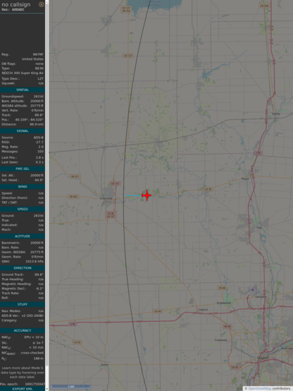
#PlaneAlert ICAO: #A8DADC Tail: #N67RF
Owner: #NOAA
Aircraft: #B350ER Super King Air
2023/08/11 07:56:58
#B350 #WeatherRecon #EmergencyResponse #StormChaser https://youtu.be/pllRW9wETzw
https://globe.adsbexchange.com/?icao=A8DADC&showTrace=2023-08-11&zoom=7&lat=40.10852&lon=-84.55334×tamp=1691755018
#planealert #a8dadc #n67rf #noaa #b350er #b350 #weatherrecon #emergencyresponse #stormchaser
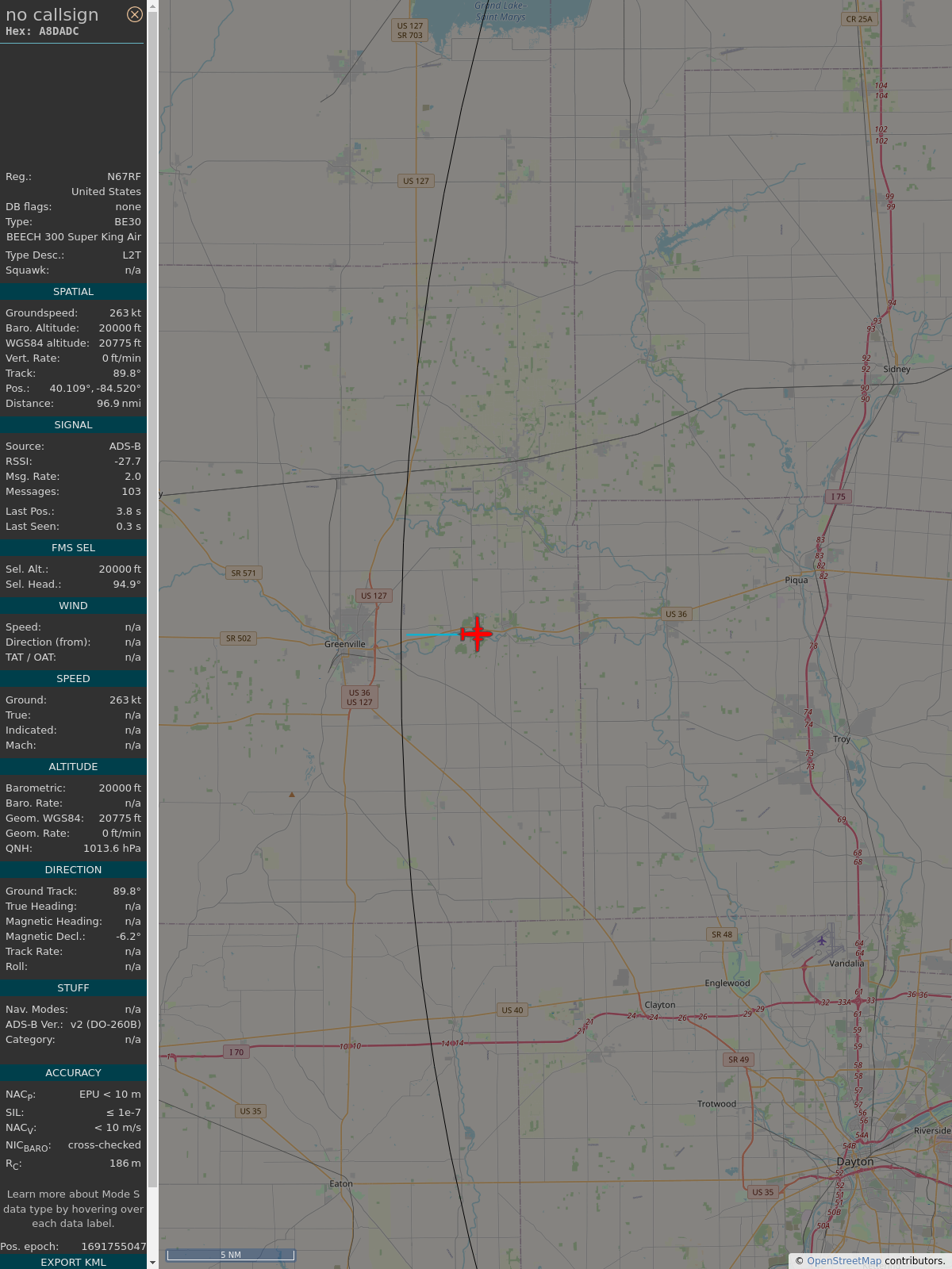
PlaneFenceCMH · @PlaneFenceCMH
8 followers · 8209 posts · Server airwaves.social
#PlaneAlert ICAO: #A8DADC Tail: #N67RF
Owner: #NOAA
Aircraft: #B350ER Super King Air
2023/08/10 08:13:34
#B350 #WeatherRecon #EmergencyResponse #StormChaser https://youtu.be/pllRW9wETzw
https://globe.adsbexchange.com/?icao=A8DADC&showTrace=2023-08-10&zoom=7&lat=42.23894&lon=-83.42653×tamp=1691669614
#planealert #a8dadc #n67rf #noaa #b350er #b350 #weatherrecon #emergencyresponse #stormchaser

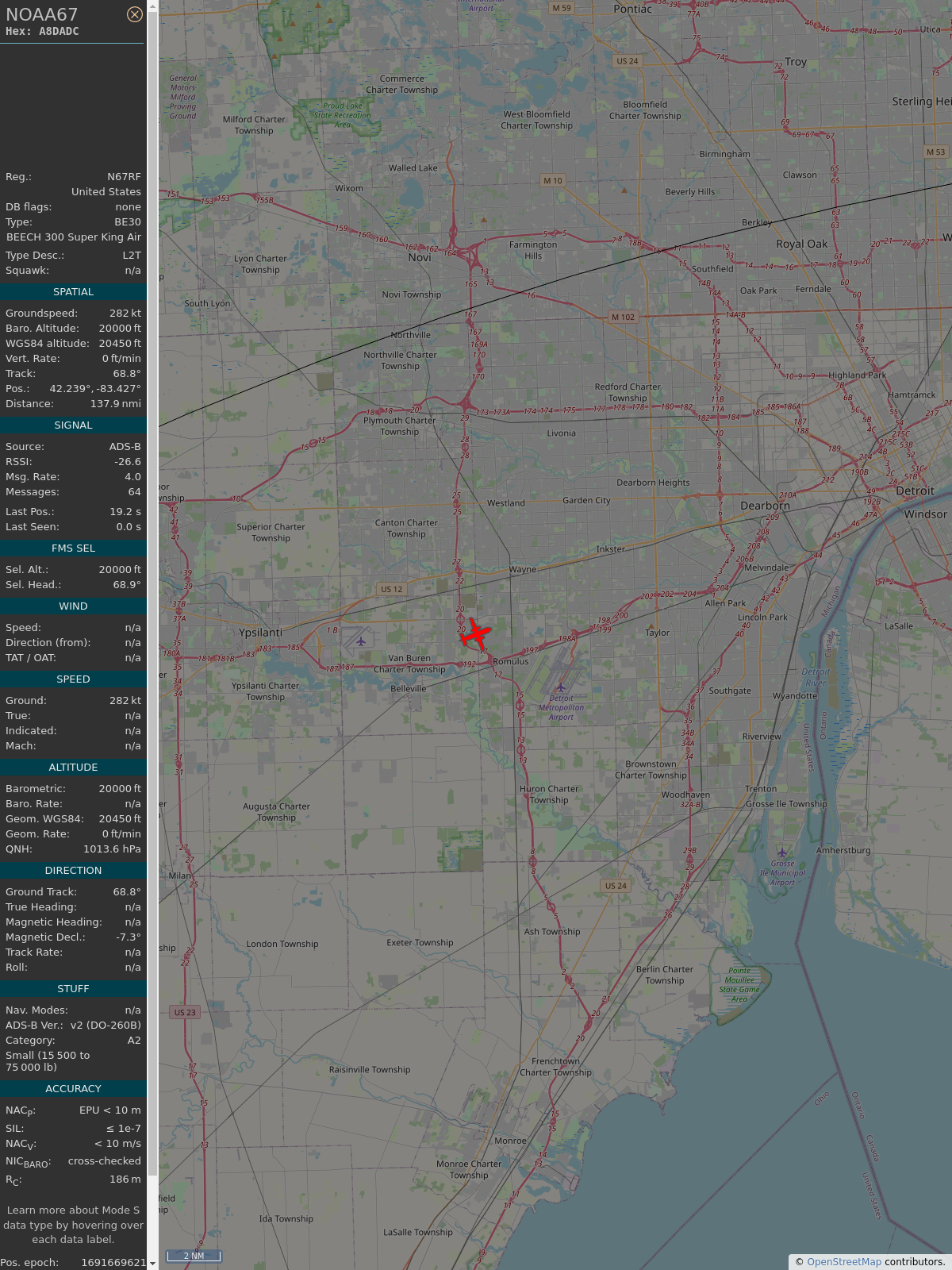
AboveBelmont · @planeboston
37 followers · 24246 posts · Server airwaves.social
#PlaneAlert ICAO: #A8DADC Tail: #N67RF
Owner: #NOAA
Aircraft: #B350ER Super King Air
2023/08/05 14:31:54
#B350 #WeatherRecon #EmergencyResponse #StormChaser https://youtu.be/pllRW9wETzw
https://globe.adsbexchange.com/?icao=A8DADC&showTrace=2023-08-05&zoom=7&lat=43.074087&lon=-70.482134×tamp=1691260314
#planealert #a8dadc #n67rf #noaa #b350er #b350 #weatherrecon #emergencyresponse #stormchaser
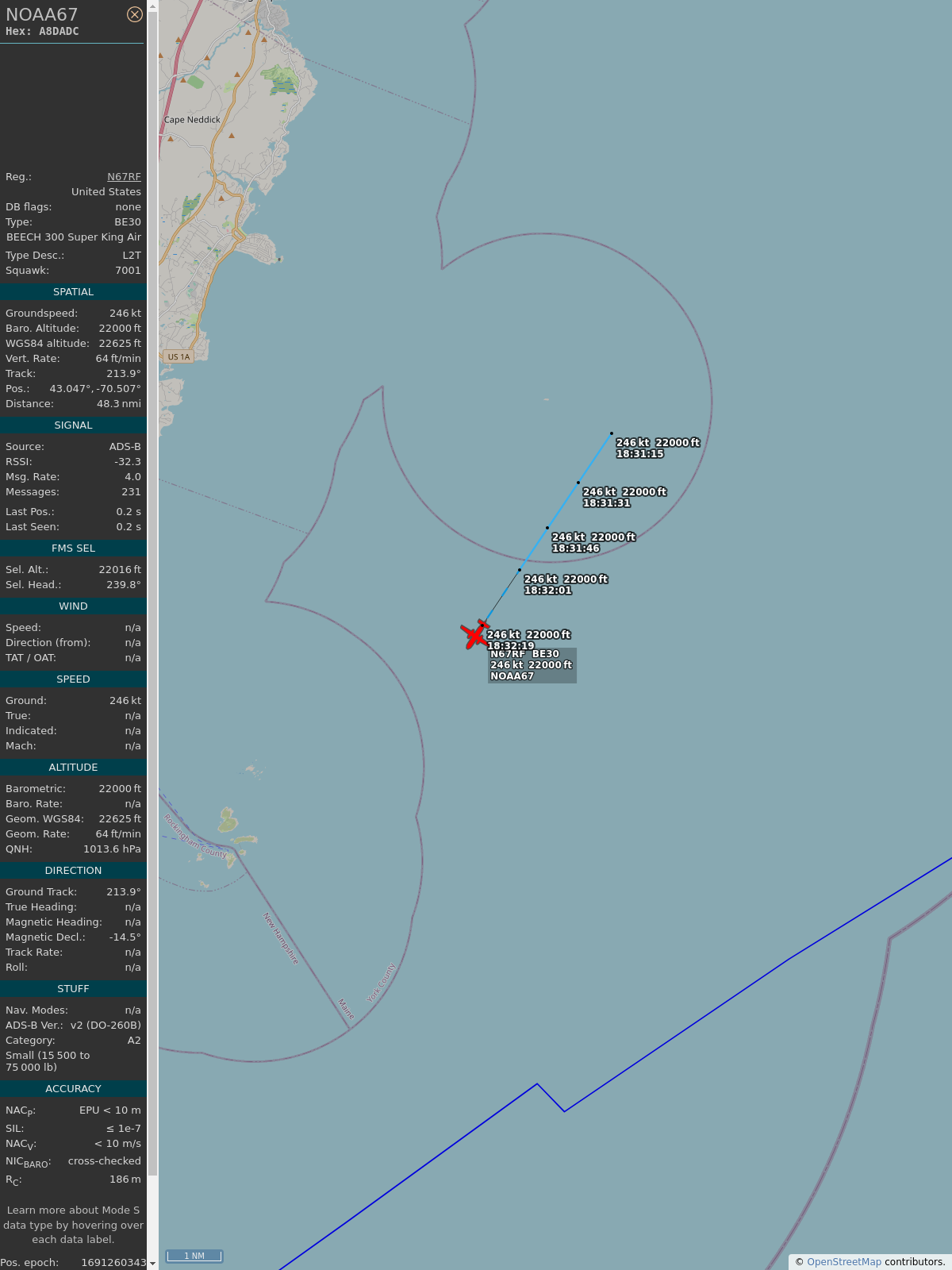
AboveBelmont · @planeboston
37 followers · 24034 posts · Server airwaves.social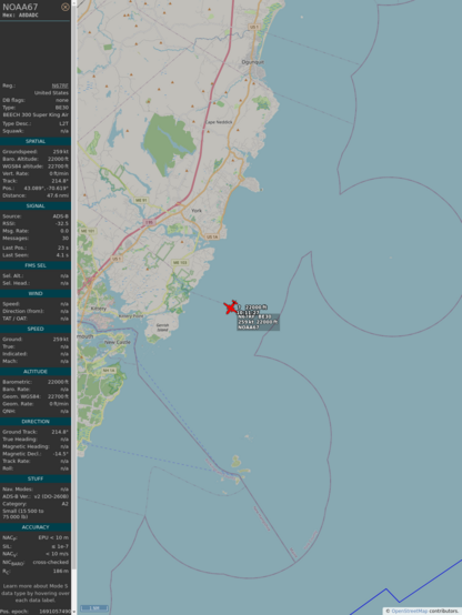
#PlaneAlert ICAO: #A8DADC Tail: #N67RF Flt: #NOAA67
Owner: #NOAA
Aircraft: #B350ER Super King Air
2023/08/03 06:11:30
#B350 #WeatherRecon #EmergencyResponse #StormChaser https://youtu.be/pllRW9wETzw
https://globe.adsbexchange.com/?icao=A8DADC&showTrace=2023-08-03&zoom=7&lat=43.088844&lon=-70.618809×tamp=1691057490
#planealert #a8dadc #n67rf #noaa67 #noaa #b350er #b350 #weatherrecon #emergencyresponse #stormchaser
GregCocks · @GregCocks
538 followers · 483 posts · Server techhub.social
Becoming A NWCG Geographic Information Systems Specialist (GISS) Trainee With The National Wildfire Coordinating Group (NWCG)
--
https://www.nwcg.gov/committees/geospatial-subcommittee/becoming-a-giss <-- technical resource for potential GISS trainees
--
https://www.nwcg.gov/positions/giss <-- GISS position description
--
https://www.nwcg.gov/ <-- National Wildfire Coordinating Group (NWCG) home page
--
#GIS #spatial #mapping #trainee #specialist #opportunity #NationalWildfireCoordinatingGroup #NWCG #GISS #wildfire #emergencyresponse #emergency #naturalhazard #spatialanalysis #emergencymanagement #training #background #incident #management
#gis #spatial #mapping #trainee #specialist #opportunity #nationalwildfirecoordinatinggroup #nwcg #giss #wildfire #emergencyresponse #emergency #naturalhazard #spatialanalysis #emergencymanagement #training #background #incident #management
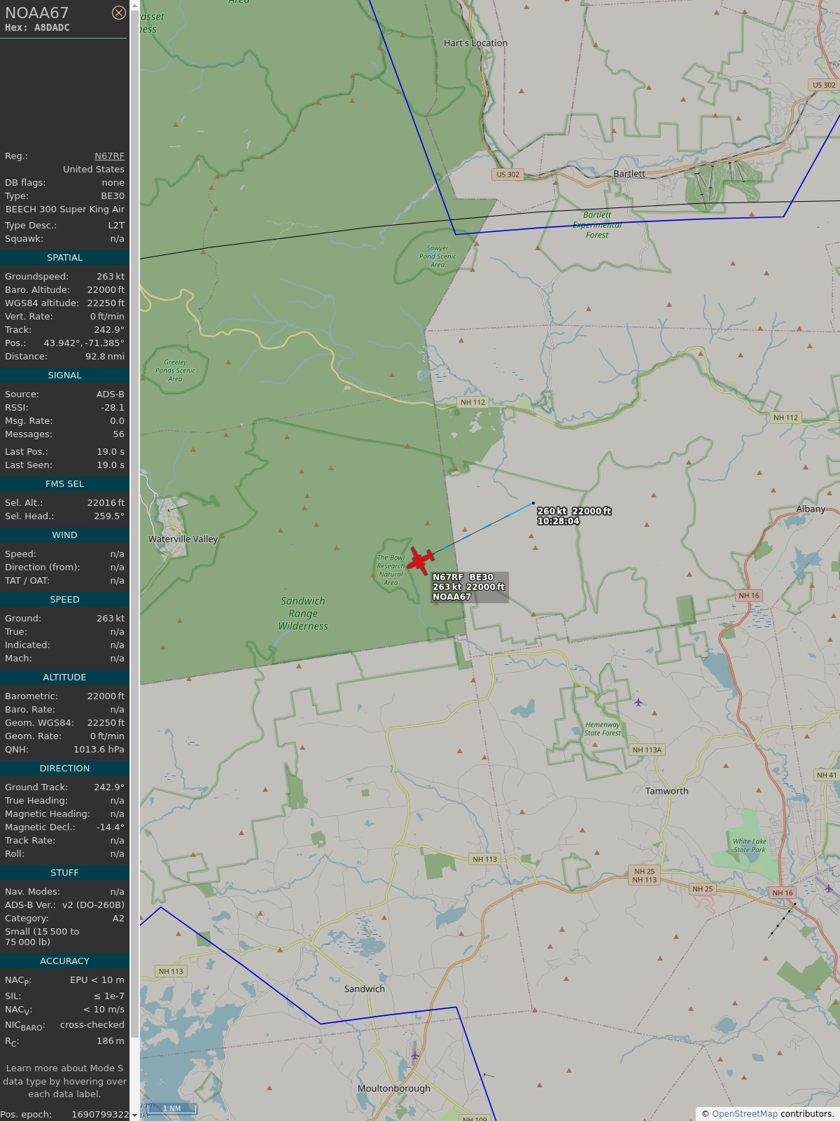
AboveBelmont · @planeboston
37 followers · 23488 posts · Server airwaves.social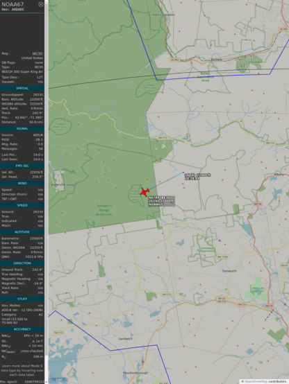
#PlaneAlert ICAO: #A8DADC Tail: #N67RF Flt: #NOAA67
Owner: #NOAA
Aircraft: #B350ER Super King Air
2023/07/31 06:28:41
#B350 #WeatherRecon #EmergencyResponse #StormChaser https://youtu.be/pllRW9wETzw
https://globe.adsbexchange.com/?icao=A8DADC&showTrace=2023-07-31&zoom=7&lat=43.941605&lon=-71.384689×tamp=1690799321
#planealert #a8dadc #n67rf #noaa67 #noaa #b350er #b350 #weatherrecon #emergencyresponse #stormchaser

AI6YR · @ai6yr
4301 followers · 27142 posts · Server m.ai6yr.org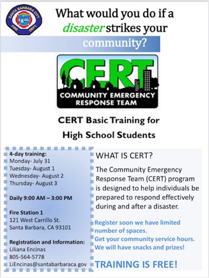
#SantaBarbara #CERT Basic Training for #HighSchool #students "We still have spots for our Teen CERT program from Monday, July 31 through Thursday, August 3, 2023, 9 AM – 3 PM. The CERT program trains individuals in disaster preparedness and emergency response." #DisasterPreparedness #EmergencyResponse
#santabarbara #cert #highschool #students #disasterpreparedness #emergencyresponse

BethelCTPride · @BethelCTPride
19 followers · 732 posts · Server masto.nycCT DOT will be doing a simulated train crash in the rail yard at Meriden train station on Saturday 7/22 to train first responders on how to respond to such events.
it will be loud, there will be simulated smoke, & actors playing injured folks.
#meriden #hartford #connecticut #trains #EMT #firefighter #emergencyresponse #train
#meriden #hartford #connecticut #trains #emt #firefighter #emergencyresponse #train
GregCocks · @GregCocks
418 followers · 450 posts · Server techhub.social
The USGS Provides Maps & Imagery For Hurricane Response
--
https://www.usgs.gov/news/featured-story/usgs-provides-maps-and-imagery-hurricane-response <-- link to technical article
--
https://apps.nationalmap.gov/event-support-map-hub/ <-- Geospatial Information Response Team (GIRT) hazard USGS The National Map (TNM) page
--
H/T #XanFredricks
“🌊For this hurricane season, the [U.S. Geological Survey (USGS) Geospatial Information Response Team] GIRT has a newly designed, publicly available Event Support Map HUB site that offers access to applications, resources and information for hurricanes and other natural disasters…”
#GIS #spatial #mapping #USGS #NGP #GIRT #EROS #NGTOC #HDDS #3DEP #TheNationalMap #science #maps #imagery #hurricanes #tropicalstorms #hazards #emergencyresponse #disasterresponse #firstresponders #supportmaps #realtimedata #information #response #gischat #appliedscience
@usgs #USGS
#xanfredricks #gis #spatial #mapping #usgs #ngp #girt #eros #ngtoc #hdds #3dep #thenationalmap #science #Maps #imagery #hurricanes #tropicalstorms #hazards #emergencyresponse #disasterresponse #firstresponders #supportmaps #realtimedata #information #response #gischat #appliedscience

Ana McKellar · @anamckellar
524 followers · 836 posts · Server mas.toLocal rowing club discovered today that their defibrillator had no power so could not provide a shock. Fortunately discovered in a random check, not an emergency. Test your #Defibrillator! Ambulance service will test for free in some areas.
#EmergencyResponse
#emergencyresponse #defibrillator

Garry Knight · @garry
1761 followers · 1957 posts · Server mstdn.socialPolice warn Android phone users over 999 call feature
'The Emergency SOS feature calls when a side button is pressed repeatedly'
By hands, butts, or pockets. My iPhone SOS goes off sometimes when I just shake my hand too quickly, even when sweeping the floor. It went through before I could catch it just once. I think...
#emergencyresponse #sos #Mobile

Above Oldsmar · @aboveoldsmar
4 followers · 819 posts · Server mastodon.nrgup.net
#PlaneAlert ICAO: #A8DADC Tail: #N67RF
Owner: #NOAA
Aircraft: #B350ER Super King Air
2023/06/19 10:40:46
#B350 #WeatherRecon #EmergencyResponse #StormChaser https://youtu.be/pllRW9wETzw
https://globe.adsbexchange.com/?icao=A8DADC&showTrace=2023-06-19&zoom=7&lat=28.980072&lon=-83.544078×tamp=1687185646
#planealert #a8dadc #n67rf #noaa #b350er #b350 #weatherrecon #emergencyresponse #stormchaser

Gaël Le Bris · @glebris
79 followers · 171 posts · Server mstdn.socialAre you looking for a guidance on the collaborative management of disruptions at #airports? Check our ACRP #Research Report 229 on #Airport Collaborative Decision Making (#ACDM) that expands the operational #resilience conversation toward all adverse conditions.
Also: don't miss this upcoming TRB Webinar: Practices in Airport #EmergencyResponse https://www.nationalacademies.org/event/06-14-2023/trb-webinar-practices-in-airport-emergency-response. ✈️🤝
#aviation #engineering #infrastructure #mobility #STEM #StrongerTogether
#strongertogether #stem #mobility #infrastructure #engineering #Aviation #emergencyresponse #resilience #acdm #airport #Research #airports
GregCocks · @GregCocks
279 followers · 364 posts · Server techhub.social
UNVT Portable - Portable MapServers For Disaster Response
--
https://github.com/unvt/portable
--
" ‘UNVT Portable’ is a package for RaspberryPi that functions as a map hosting server and can be freely accessed from a web browser within a local network.
It is mainly intended to function in an offline environment during times of severe disaster, and is expected to play an active role... where disaster response headquarters are set up to assess the situation and respond to disasters by combining aerial drone images taken after a disaster occurs with OpenStreetMap and various open data tile data sets prepared in advance…”
#GIS #spatial #mapping #gischat #portable #mapserver #raspberrypi #raspberry #hosting #server #webbrowser #localnetwork #onsite #disasterresponse #hardware #solution #opensource #openformat #responsecenter #disasterresponsecenter #headquarters #readyresponse #mobile #mobileoffice #emergencyresponse #emergencymanagement #emergencypreparedness #risk #hazard #onlinemapping
#gis #spatial #mapping #gischat #portable #MapServer #raspberrypi #raspberry #hosting #server #webbrowser #localnetwork #onsite #disasterresponse #hardware #solution #opensource #openformat #responsecenter #disasterresponsecenter #headquarters #readyresponse #mobile #mobileoffice #emergencyresponse #emergencymanagement #emergencypreparedness #risk #hazard #onlinemapping
Above Oldsmar · @aboveoldsmar
2 followers · 878 posts · Server mastodon.nrgup.net
#PlaneAlert ICAO: #A8DADC Tail: #N67RF Flt: #NOAA67
Owner: #NOAA
Aircraft: #B350ER Super King Air
2023/06/06 12:49:30
#B350 #WeatherRecon #EmergencyResponse #StormChaser https://youtu.be/pllRW9wETzw
https://globe.adsbexchange.com/?icao=A8DADC&showTrace=2023-06-06&zoom=7&lat=28.010156&lon=-82.540768×tamp=1686070170
#planealert #a8dadc #n67rf #noaa67 #noaa #b350er #b350 #weatherrecon #emergencyresponse #stormchaser
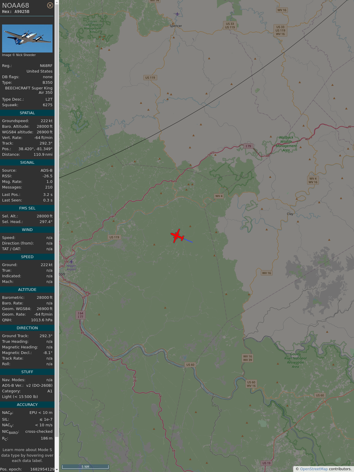
PlaneFenceCMH · @PlaneFenceCMH
1 followers · 1027 posts · Server airwaves.social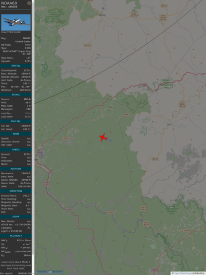
#PlaneAlert ICAO: #A9025B Tail: #N68RF Flt: #NOAA68
Owner: #NOAA
Aircraft: #B350ER Super King Air
2023/05/01 11:15:02
#B350 #WeatherRecon #EmergencyResponse #StormChaser https://youtu.be/pllRW9wETzw
https://globe.adsbexchange.com/?icao=A9025B&showTrace=2023-05-01&zoom=7&lat=38.40948&lon=-81.31671×tamp=1682954102
#planealert #a9025b #n68rf #noaa68 #noaa #b350er #b350 #weatherrecon #emergencyresponse #stormchaser
Above Oldsmar · @aboveoldsmar
0 followers · 913 posts · Server mastodon.nrgup.net
#PlaneAlert ICAO: #A9025B Tail: #N68RF Flt: #NOAA68
Owner: #NOAA
Aircraft: #B350ER Super King Air
2023/04/29 10:16:06
#B350 #WeatherRecon #EmergencyResponse #StormChaser https://youtu.be/pllRW9wETzw
https://globe.adsbexchange.com/?icao=A9025B&showTrace=2023-04-29&zoom=7&lat=28.315063&lon=-82.344906×tamp=1682777766
#planealert #a9025b #n68rf #noaa68 #noaa #b350er #b350 #weatherrecon #emergencyresponse #stormchaser
Gaël Le Bris · @glebris
40 followers · 144 posts · Server mstdn.social
This is a good blog article from the European Union Aviation Safety Agency (EASA) on Emergency Medical Services by Vertical Take-off and Landing aircraft: https://www.easa.europa.eu/en/light/topics/emergency-medical-services-vertical-take-and-landing-aircraft. 🚁
#aircraft #aviation #ElectricAircraft #EmergencyResponse #eVTOLs #MedicalServices #mobility #VerticalFlight #VTOLs
#vtols #verticalflight #mobility #medicalservices #eVTOLS #emergencyresponse #electricaircraft #Aviation #aircraft