GregCocks · @GregCocks
609 followers · 553 posts · Server techhub.socialA New, Underground Atlas Of Subduction Zones [EOS]
--
https://eos.org/articles/a-new-underground-atlas-of-subduction-zones <-- shared technical article
--
https://submap.gm.umontpellier.fr/ <-- Submap, a tool for mapping subduction zones
--
“Graphic design meets geoscience…
Submap is a user-friendly tool that allows anyone with an Internet connection to create quick, custom maps of subduction zones…"
#GIS #spatial #mapping #visual #visualisation #visualization #subduction #geology #structuralgeology #Submap #geoscience #global #earth #platetectonics #subductionzones #earthquake #model #modeling #3dmapping #3dmodeling #opensource #opendata #tsunami #monitoring #fault #faulting #VisualizationTools #maps #crosssections
#gis #spatial #mapping #visual #visualisation #visualization #subduction #geology #structuralgeology #submap #geoscience #global #earth #platetectonics #subductionzones #earthquake #model #modeling #3dmapping #3dmodeling #opensource #opendata #tsunami #monitoring #fault #faulting #visualizationtools #Maps #crosssections
GregCocks · @GregCocks
587 followers · 525 posts · Server techhub.socialFantastically Folded Rocks and the Beautiful Butte Fault - A Major Structure in the Grand Canyon
--
https://youtu.be/0yC5tc8KJoI <-- shared video
--
H/T Shawn Willsey
“Hike up scenic Carbon Canyon in the Grand Canyon with geology professor Shawn Willsey to investigate the sexy and magnificent rocks exposed along the Butte Fault. Learn how this fault formed, reversed its direction of movement, and made the East Kaibab Monocline…”
#GIS #spatial #mapping #geological #geologymapping #geologicmapping #fault #faulting #structuralgeology #fieldwork #model #modeling #CarbonCanyon #grandcanyon #USA #ButteFault
#gis #spatial #mapping #geological #geologymapping #geologicmapping #fault #faulting #structuralgeology #fieldwork #model #modeling #carboncanyon #grandcanyon #USA #buttefault
Jascha Polet · @jascha
797 followers · 228 posts · Server mastodon.socialMap of current #Turkey #earthquake sequence from AFAD catalog, includes M>4.5 focal mechanisms. 3 largest quakes are mostly strike slip, but many #aftershocks also show normal #faulting.
(dark purple: events between M7.8 & M7.6; light purple: after M7.6; light blue: after M6.3)
#turkey #earthquake #Aftershocks #faulting
GregCocks · @GregCocks
101 followers · 113 posts · Server techhub.socialQuantitative Tectonic Geomorphic Study From Bedrock Rivers Of The Fold And Thrust Belt In The Bengal Basin
--
https://doi.org/10.1002/gj.4669 <-- shared paper
--
#GIS #spatial #modeling #mapping #spatialanalysis #geology #tectonics #geomorphology #BayOfBengal #BengalBasin #hydrology #rivers #people #risk #hazard #geomorphic #structuralgeology #india #bangladesh #platetectonics #remotesensing #DEM #elevation #bathymetry #topobathy #hydrospatial #uplift #fault #faulting #earthquakes #drainage #watersheds #basins #network
#gis #spatial #modeling #mapping #spatialanalysis #geology #tectonics #geomorphology #bayofbengal #bengalbasin #hydrology #rivers #people #risk #hazard #geomorphic #structuralgeology #india #Bangladesh #platetectonics #remotesensing #dem #elevation #bathymetry #topobathy #hydrospatial #uplift #fault #faulting #earthquakes #drainage #watersheds #basins #network
Jascha Polet · @jascha
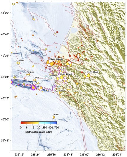
665 followers · 164 posts · Server mastodon.socialMap of today's M5.4 #earthquake near Rio Dell in the context of the #seismicity in the region in the past year or so. This strike-slip #faulting event has depth estimates of 28-39 km, a bit deeper than the #quake from a year ago (and significantly towards E) with a similar mechanism.
#earthquake #seismicity #faulting #quake
Jascha Polet · @jascha
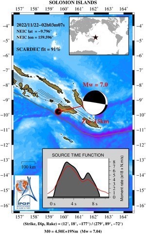
396 followers · 67 posts · Server mastodon.socialUnexpected focal mechanism for M7.0 earthquake near #Solomon Islands. I would have expected a shallow thrust #earthquake on the #subduction interface, but it appear to be a steep #normal #faulting event. As of yet, only possible #tsunami waves on the nearby Honiara sea level station are a few cms in amplitude.
#solomon #earthquake #subduction #normal #faulting #tsunami


