
M Pietila · @pnwamateur
167 followers · 482 posts · Server ecoevo.social
Panoramic view of smoke from the fire from the Oak Flat area just now, looking roughly south to west
M Pietila · @pnwamateur
162 followers · 471 posts · Server ecoevo.socialLooks like we're down to a level 1 evacuation!
M Pietila · @pnwamateur
162 followers · 471 posts · Server ecoevo.social
#FlatFire Apparently they really did get approval to bring heavy equipment into the Kalmiopsis Wilderness. I can understand why that might be seen as essential to protect Gold Beach to Brookings on the coast from this fire but it also feels like an enormous shift in the conception of what a roadless wilderness area is intended to be.
Story from Zach Urness:
https://www.statesmanjournal.com/story/news/local/2023/07/24/oregon-wildfires-flat-fire-kalmiopsis-wilderness-heavy-equipment-forest-service/70457260007/
M Pietila · @pnwamateur
162 followers · 458 posts · Server ecoevo.social
View west-southwest-ish from the Oak Flat community area (up Old House Creek) this morning - looking out over the Illinois River valley. Smoky but not horrible at this spot. The morning inversion hasn't lifted yet.
Fire crews have been up at our place here clearing some of the brush and small trees - we were 30' out from buildings, they brought it up to 50'.

Harold Schmidt · @oldredsubby
2051 followers · 19680 posts · Server sfba.socialFlat Fire @ Area of Oak Flat Campground 2.5 miles south of Agness, Curry County - #FlatFire

Joseph Elfelt · @mappingsupport
329 followers · 245 posts · Server m.ai6yr.org
July 21 morning. Weather prevented an infrared flight last night for the #FlatFire in SW Oregon. Hopefully that area got some rain.
Open #GISsurfer map:
https://mappingsupport.com/p2/gissurfer.php?center=42.461715,-124.173660&zoom=11&basemap=USA_basemap&overlay=Wildland_fire_name,MODIS_7_day,VIIRS_7_day,USA_roads,Lake_river_stream&data=https://mappingsupport.com/p2/special_maps/disaster/USA_wildland_fire.txt
Joseph Elfelt · @mappingsupport
324 followers · 238 posts · Server m.ai6yr.org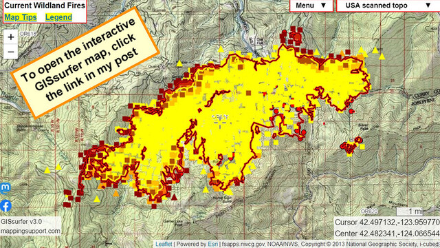
July 20 morning. Interactive #GIS map for #FlatFire SW Oregon.
When the map opens the “Fire weather forecast” overlay is ‘on’. To read that forecast, open the map, click the fire, follow the link.
If you have not read the “Map tips” (link in upper left corner) then you will get more benefit from the map if you take a few minutes and read through that info.
#ORwx #ORfire #GoldBeach #GIS #Geospatial #Maps #Mapping #Leaflet #ArcGIS #WebMap
Open #GISsurfer map:
https://mappingsupport.com/p2/gissurfer.php?center=42.482341,-124.066544&zoom=12&basemap=USA_scanned_topo&overlay=Wildland_fire_name,MODIS_7_day,VIIRS_7_day,USA_roads,State_boundary,NOAA_fire_weather_forecast&fire=OR,Flat&fire=OR,Flat&data=https://mappingsupport.com/p2/special_maps/disaster/USA_wildland_fire.txt
#gis #flatfire #orwx #orfire #goldbeach #geospatial #maps #mapping #leaflet #arcgis #webmap #gissurfer
Joseph Elfelt · @mappingsupport
323 followers · 237 posts · Server m.ai6yr.org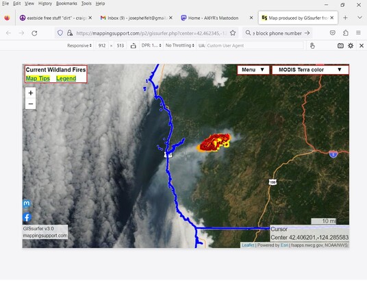
July 19 afternoon. Interactive #GIS map for #FlatFire SW Oregon.
View by MODIS Terra satellite. The MODIS satellites build a new image of the earth each day. Later in the day the map will open with a white background since the satellite has started to build a new image.
Map has lots of fire related layers you can turn on. Click “Map tips” upper left corner for help.
#ORwx #ORfire #GoldBeach #GIS #Geospatial #Maps #Mapping #Leaflet #ArcGIS #WebMap
Open #GISsurfer map:
https://mappingsupport.com/p2/gissurfer.php?center=42.406201,-124.285583&zoom=9&basemap=MODIS_Terra_color&overlay=Wildland_fire_name,MODIS_7_day,VIIRS_7_day,USA_roads,State_boundary&fire=OR,Flat&fire=OR,Flat&data=https://mappingsupport.com/p2/special_maps/disaster/USA_wildland_fire.txt
#gis #flatfire #orwx #orfire #goldbeach #geospatial #maps #mapping #leaflet #arcgis #webmap #gissurfer

ianoji · @ianoji
43 followers · 635 posts · Server sfba.social
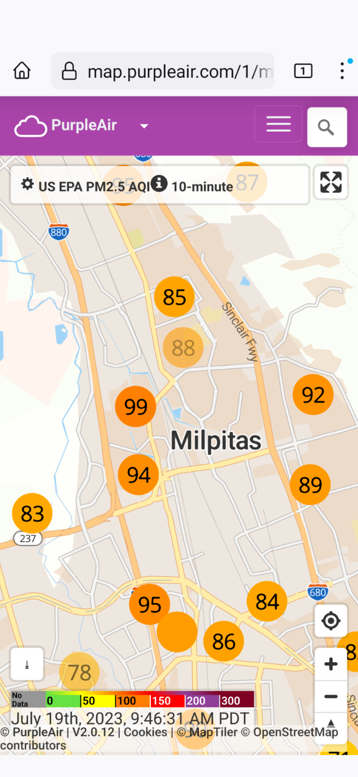
#cawx #FireSeason begins for me. 100 AQI is where I start having trouble falling asleep due to coughing and post nasal drip with windows open.
#PikaFire #FlatFire burning away, prevailing winds giving me all the spices
#cawx #fireseason #pikafire #flatfire
Joseph Elfelt · @mappingsupport
319 followers · 230 posts · Server m.ai6yr.org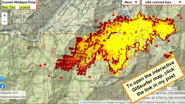
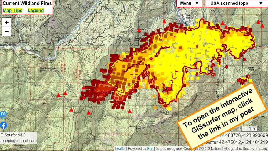
July 19 morning. Interactive #GIS map for #FlatFire SW Oregon.
Infrared flight last night 10:27pm. IR analyst determined 12,756 acres burned and fire made 4 mile run to the west in prior 24 hours. Continued spotting to the west.
To get the most benefit from the map see the 2 links in upper left corner.
#ORwx #ORfire #GoldBeach #Geospatial #Maps #Mapping #Leaflet #ArcGIS #WebMap
Open #GISsurfer map:
https://mappingsupport.com/p2/gissurfer.php?center=42.462345,-124.132118&zoom=12&basemap=USA_scanned_topo&overlay=Wildland_fire_name,MODIS_7_day,VIIRS_7_day&fire=OR,Flat&fire=OR,Flat&data=https://mappingsupport.com/p2/special_maps/disaster/USA_wildland_fire.txt
#gis #flatfire #orwx #orfire #goldbeach #geospatial #maps #mapping #leaflet #arcgis #webmap #gissurfer
Joseph Elfelt · @mappingsupport
317 followers · 227 posts · Server m.ai6yr.org
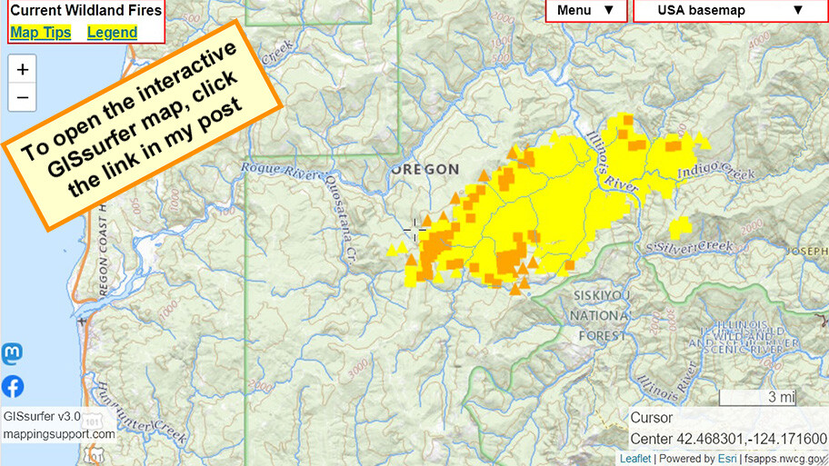
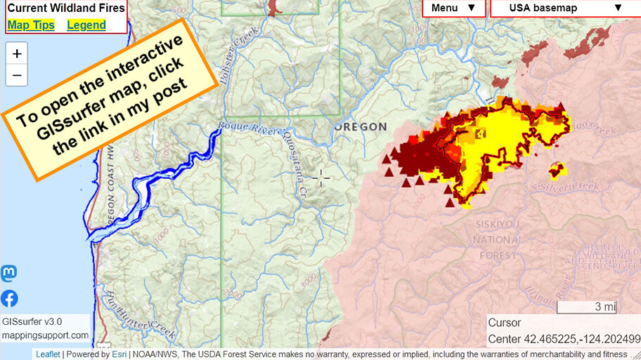
July 18 afternoon. #FlatFire SW Oregon.
The wind has been blowing to the west so some of the MODIS and VIIRS heat detections might be smoke+embers but not actual fire on the ground.
If there is an infrared flight tonight then I will post an updated map in the morning showing the latest perimeter and acres burned.
To get the most benefit from the map read the "Map tips" - link in upper left corner.
Open #GISsurfer map:
https://mappingsupport.com/p2/gissurfer.php?center=42.455090,-124.202499&zoom=11&basemap=USA_basemap&overlay=State_boundary,Wildland_fire_name,Lake_river_stream,Historic_perimeters,MODIS_7_day,VIIRS_7_day&fire=OR,Flat&fire=OR,Flat&data=https://mappingsupport.com/p2/special_maps/disaster/USA_wildland_fire.txt
Joseph Elfelt · @mappingsupport
314 followers · 225 posts · Server m.ai6yr.org
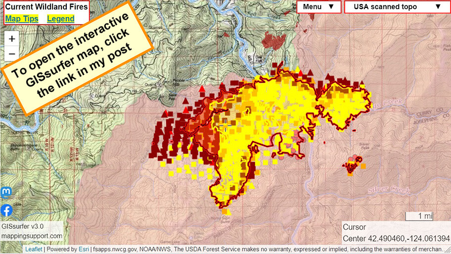
July 18. #FlatFire SW Oregon.
Infrared flight last night 10:27pm. IR analyst determined 8,204 acres burned, significant spotting to the west. Red shading = intense heat.
MODIS/VIIRS satellite heat detection shows fire has continued moving west. If it crosses the next ridge then the remaining land out to the coast has not burned for 20+ years.
#ORwx #ORfire #Wildfire #GIS #Geospatial #Maps #Mapping #Leaflet #ArcGIS #WebMap
Open #GISsurfer map:
https://mappingsupport.com/p2/gissurfer.php?center=42.481342,-124.064827&zoom=12&basemap=USA_scanned_topo&overlay=State_boundary,Wildland_fire_name,Lake_river_stream,USA_roads,Historic_perimeters,MODIS_7_day,VIIRS_7_day&fire=OR,Flat&fire=OR,Flat&data=https://mappingsupport.com/p2/special_maps/disaster/USA_wildland_fire.txt
#flatfire #orwx #orfire #Wildfire #gis #geospatial #maps #mapping #leaflet #arcgis #webmap #gissurfer

Zoom Earth · @zoom_earth
1206 followers · 507 posts · Server mapstodon.spaceWildfire season is heating up on the US West coast. Latest satellite view of smoke + heat from #FlatFire in Curry County, Oregon:

Geewhizpat · @Geewhizpat
848 followers · 2600 posts · Server newsie.social
CALFIRE Butte Bot · @calfire_butteco_bot
2 followers · 26 posts · Server m.ai6yr.org
CALFIRE Butte Bot · @calfire_butteco_bot
2 followers · 25 posts · Server m.ai6yr.org
CALFIRE Butte Bot · @calfire_butteco_bot
2 followers · 24 posts · Server m.ai6yr.org
MiBaWi - Michael Barthel · @MiBaWi
264 followers · 704 posts · Server m.ai6yr.org#Flatfire at Chinese Wall Road & Swedes Flat Road in #ButteCounty / #California
1/4 acre
grass & brush
slow / moderate ros
Watch Duty > https://app.watchduty.org/i/2712#allow-back
#flatfire #buttecounty #california