
Tom Montgomery · @tom30519
355 followers · 1257 posts · Server fosstodon.org@65dBnoise
We don't yet have RTE images from #Flight43, let alone #Flight44.
Unless Ingenuity was in such a rush to get ahead that no RTE photos were taken, but that would be very unlikely, I'd think.

65dBnoise · @65dBnoise
1295 followers · 170 posts · Server mastodon.socialKen Farley's presentation in #MEPAG39 showed a path along the east side of the foothills that lie to the west of the valley ahead of #Perseverance, but more interestingly it shows a mark for science activity around the place where #Ingenuity is currently located after its #Flight44.
The red mark shows the #MarsHelicopter's 44th landing, the green path is from the presentation. The background map is drawn in #QGIS with data from #HiRISE and #MMGIS
#MEPAG39 #perseverance #ingenuity #flight44 #marshelicopter #qgis #hirise #MMGIS #mars2020 #nasa #solarocks #space
65dBnoise · @65dBnoise
1295 followers · 170 posts · Server mastodon.socialKen Farley's presentation in #MEPAG39 showed a path along the east side of the foothills that lie to the west of the valley ahead of #Perseverance, but more interestingly it shows a mark for science activity around the place where #Ingenuity is currently located its #Flight44.
The red mark shows the #MarsHelicopter's 44th landing, the green path is from the presentation. The background map is drawn in #QGIS with data from #HiRISE and #MMGIS
#MEPAG39 #perseverance #ingenuity #flight44 #marshelicopter #qgis #hirise #MMGIS #mars2020 #nasa #solarocks #space
65dBnoise · @65dBnoise
1295 followers · 170 posts · Server mastodon.socialKen Farley's presentation in #MEPAG39 showed a path along the east side of the foothills of the valley that lies ahead of #Perseverance, but more interestingly it shows a mark for science activity around the place where #Ingenuity is currently located its #Flight44.
The red mark shows the #MarsHelicopter's 44th landing, the green path is from the presentation. The background map is drawn in #QGIS with data from #HiRISE and #MMGIS
#MEPAG39 #perseverance #ingenuity #flight44 #marshelicopter #qgis #hirise #MMGIS #mars2020 #nasa #solarocks #space
65dBnoise · @65dBnoise
1297 followers · 157 posts · Server mastodon.social
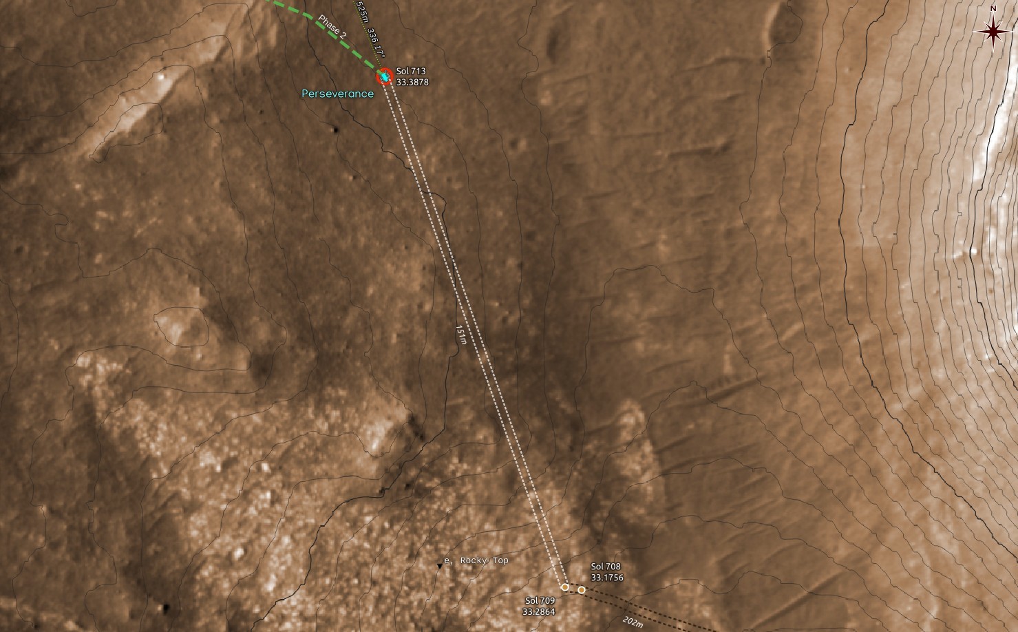
#Perseverance moved to a new location on Sol 713, RMC 33.3878, about 150m NNW. The map shows an estimate of the new location based on the images received so far and their JSON metadata. The path (white dashed line) is just a guess.
Apparently #Ingenuity has now a clear LOS and a better comms link, so we should expect more #Flight44 images to appear shortly.
#perseverance #ingenuity #flight44 #mars2020 #nasa #solarocks #space
65dBnoise · @65dBnoise
1297 followers · 157 posts · Server mastodon.social#Perseverance moved to a new location on Sol 713, RMC 33.3878, about 150m NNW. The map shows an estimate of the new location based on the images received so far and their JSON metadata. The path (white dashed line) is just a guess.
Apparently #Ingenuity is now clearly visible, so we should expect more #Flight44 images to appear shortly.
#perseverance #ingenuity #flight44 #mars2020 #nasa #solarocks #space
65dBnoise · @65dBnoise
1298 followers · 140 posts · Server mastodon.socialIt appears #Ingenuity did fly its #Flight44 yestersol. Here is a sample of the area it (probably) landed:
2 processed HELI_NAV animated at 1fps
RMC: 0.None, Sol: 711, LMST: 16:07:29
Original: https://mars.nasa.gov/mars2020-raw-images/pub/ods/surface/sol/00711/ids/edr/browse/heli/HNM_0711_0730072512_058ECM_N0440001HELI04486_0000A0J01.png
Credit: #NASA/JPL-Caltech/65dBnoise
#nasa #marshelicopter #mars2020 #solarocks #space #ingenuity #flight44
65dBnoise · @65dBnoise
1295 followers · 126 posts · Server mastodon.social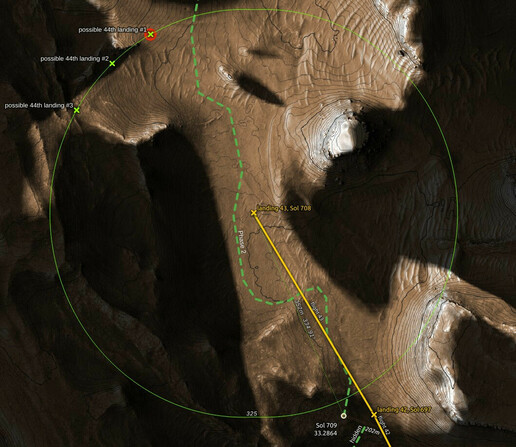
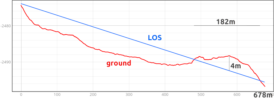
The great distance and the 4m max, 182m long obstruction presented by the ground close to the rover may indicate that #Flight44 may not occur before #Perseverance moves past that obstruction. The drive that may lead the rover to a clearer path appears to be less than 100m toward the N/NW.
With so little information about the short term plans of the #Mars2020 team, all one can do is speculate. Hopefully there is some substance in the above speculation.
#flight44 #perseverance #mars2020 #nasa #ingenuity #marshelicopter
65dBnoise · @65dBnoise
1295 followers · 125 posts · Server mastodon.social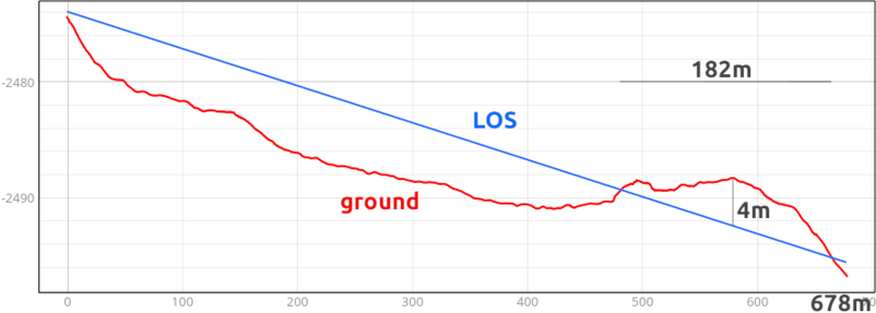
the 126m long obstruction had a depth of 1.3m.
There is no data available on radio propagation in UHF frequencies at ground level on Mars; one similar situation might have been encountered in the Apollo missions on the Moon, but it is unknown to me if any radio propagation study was carried out before or after those missions.
Putting the above to work for #Flight44, we see that the distance to a possible #Flight44 landing is around 675m, almost 2x that of #Flight43.
3/