
65dBnoise · @65dBnoise
1299 followers · 269 posts · Server mastodon.social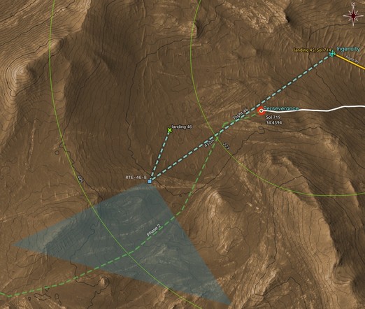
This localization of #Ingenuity's RTE-46-8 image suggests that there will be no image capturing the inside of Belva Crater. Apparently #Perseverance will continue its run, now turning SW. The heli will most probably precede the rover with #Flight47 toward the direction of the RTE image shown above.
The total length of the flight shown with a dashed cyan line does not add up to the 445m mentioned in #NASA's announcement.
#MarsHelicopter #Flight46 #Mars2020 #Solarorocks #Space #localization
#ingenuity #perseverance #flight47 #nasa #marshelicopter #flight46 #mars2020 #solarorocks #space #localization
65dBnoise · @65dBnoise
1299 followers · 268 posts · Server mastodon.socialRefinement of the #Flight46 landing location based on one HELI_NAV image. Animation.
Some interesting conclusions coming up 😎
Processed, quick georeferenced HELI_NAV
Flight: 46, Sol: 717, LMST: 16:08:23
Original: https://mars.nasa.gov/mars2020-raw-images/pub/ods/surface/sol/00717/ids/edr/browse/heli/HNM_0717_0730605214_739ECM_N0460001HELI04305_0000A0J01.png
Credit: #NASA/JPL-Caltech/65dBnoise
#Ingenuity #Flight46 #Mars2020 #Solarorocks #Space #localization
#flight46 #nasa #ingenuity #mars2020 #solarorocks #space #localization
65dBnoise · @65dBnoise
1299 followers · 261 posts · Server mastodon.social
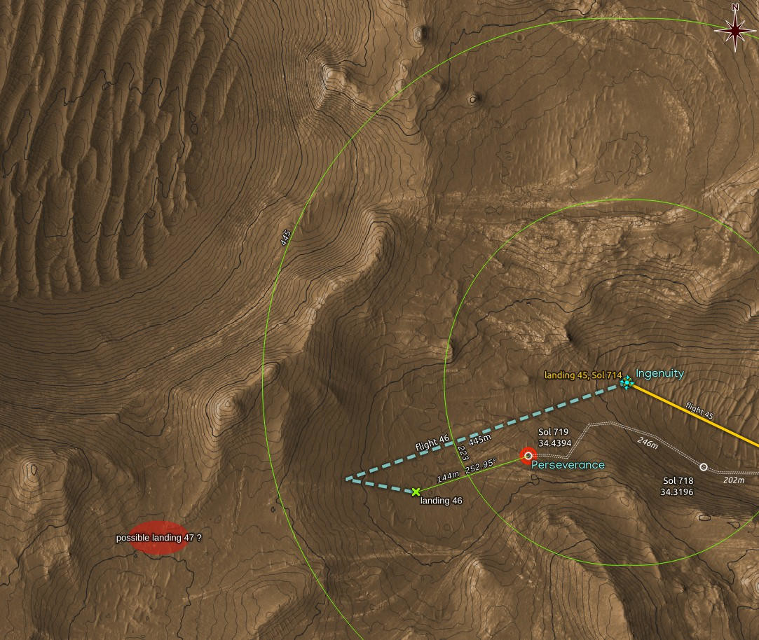
@stim3on @tom30519 And if wondering why that path and not anything else that would too add to 445m, well, "scout future airfields" has a special meaning close to Belva Crater 😃
Is the red ellipse a future airfield that will allow some epic pictures to be taken by the #marshelicopter
#Ingenuity #Flight46 $Flight47 #Perseverance #Mars2020 #Solarorocks #Space
#marshelicopter #ingenuity #flight46 #perseverance #mars2020 #solarorocks #space
65dBnoise · @65dBnoise
1299 followers · 261 posts · Server mastodon.social@stim3on @tom30519 And if wondering why that path and not anything else that would too add to 445m, well, "scout future airfields" has a special meaning close to Belva Crater 😃
Is the red ellipse a future airfield that will allow some epic pictures to be taken by the #marshelicopter
#Ingenuity #Flight46 $Flight47 #Perseverance #Mars2020 #Solarorocks #Space
#marshelicopter #ingenuity #flight46 #perseverance #mars2020 #solarorocks #space
65dBnoise · @65dBnoise
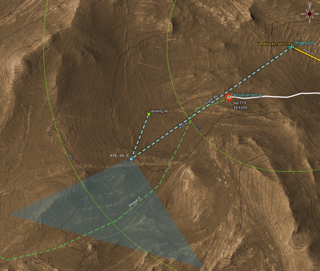
1298 followers · 259 posts · Server mastodon.social@stim3on has spotted what appears to be the #MarsHelicopter at its 46th landing location.
The map below shows my estimate of that location, together with a guessed flight path that totals 445m, as given in #NASA's announcement for #Flight46
https://mastodon.social/@stim3on@fosstodon.org/109938215330881100
#marshelicopter #nasa #flight46 #mars2020 #solarocks #space
65dBnoise · @65dBnoise
1299 followers · 256 posts · Server mastodon.social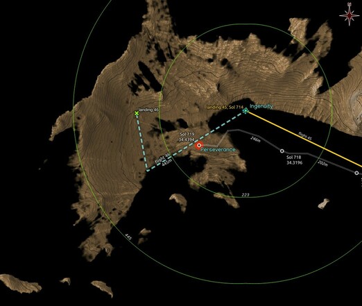
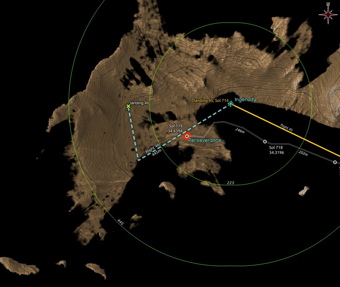
#Ingenuity should now be visible no matter where it landed after #Flight46, since most of the area for a possible landing is now visible from RMC 34.4394 where #Perseverance arrived after the Sol 719 drive.
Dashed flight path and 46th landing in cyan are wild guesses,
Map made using #QGIS with data from #NASA's #MMGIS and #HiRISE
#ingenuity #flight46 #perseverance #qgis #nasa #MMGIS #hirise #mars2020 #solarocks #space #visibility
65dBnoise · @65dBnoise
1299 followers · 256 posts · Server mastodon.social
#Ingenuity should now be visible no matter where it landed after #Flight46, since most of the area for a possible landing is now visible from RMC 34.4394 where #Perseverance arrived after the Sol 719 drive.
Dashed flight path and 46th landing in cyan are wild guesses,
Map made using #QGIS with data from #NASA's #MMGIS and #HiRISE
#ingenuity #flight46 #perseverance #qgis #nasa #MMGIS #hirise #mars2020 #solarocks #space #visibility
65dBnoise · @65dBnoise
1297 followers · 208 posts · Server mastodon.social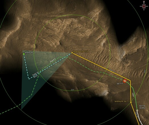
Maybe someone will have a better interpretation of the phrase "w/ max divert" which appears in #NASA's announcement for #Ingenuity's #Flight46 (https://mars.nasa.gov/technology/helicopter/status/447/flight-46-preview-by-the-numbers/), but I take it to mean a dog legged flight path (cyan dashed line) with landing between the outer reach and the takeoff location, somewhere within the triangle. This mystery plot appears in the following map, also showing assumed NLOS radio coverage for the rover.
It's a guess:
#nasa #ingenuity #flight46 #marshelicopter #mars2020 #solarocks #space