
Thomas Weibel · @thomasweibel
458 followers · 2289 posts · Server swiss.social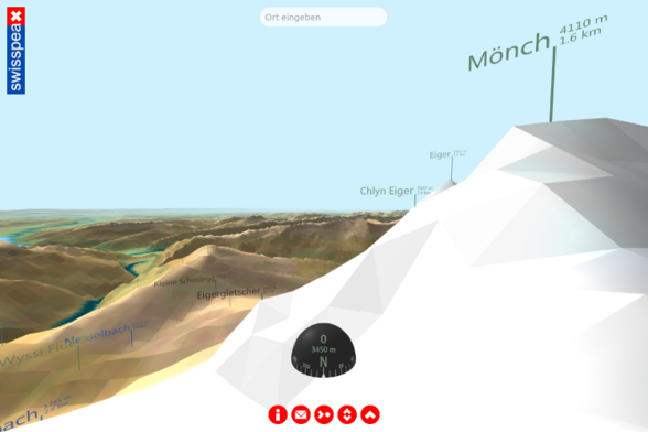
Projekt #swisspeaX: Die Schweiz in 3D. https://www.thomasweibel.ch/swisspeax/ #vr #opendata #openglam #geodata #swisstopo #aframe #javascript @OpendataCH @OpenDataZurich @opendata @amicale.net @OpenDataZH
#swisspeax #vr #opendata #openglam #geodata #swisstopo #aframe #javascript

Michael Nagenborg (he/him) · @mnagenborg
121 followers · 31 posts · Server social.edu.nlI am also happy to share a pre-print of our joint paper on #ThreatModelling for #Geodata in the #HumanitarianContext . This one of the less philosophical papers within our interdisciplinary project, but really helpful for us to discuss #bias in geospatial #AI . https://www.preprints.org/manuscript/202308.0312/v1
#threatmodelling #geodata #humanitariancontext #bias #ai

HeiGIT · @heigit
129 followers · 99 posts · Server mapstodon.space
Earlier this month, we´ve been at the Summer School Disaster Risk Reduction 2023, a one-week course on disaster #RiskManagement & prevention hosted at @UmweltCampus by @DKKV_GermanDRR.
👉Read more about our field trips and workshops on #geodata for #DRR: https://heigit.org/heigit-at-summer-school-disaster-risk-reduction-2023/

Vergismatrix · @Vergismatrix
3 followers · 6 posts · Server fosstodon.orgHello Mastadoneans, for a landparcel project I would like to do some #dataanalysis with the ratio between $area and $perimiter of a polygon feature.
Does someone know a basic textbook chapter around this idea? The do’s en don’ts to start with for example? Or a #researchpaper where this is explored?
I do know how to calculate the ratio and add the value to an attribute. I’m just looking for something how to use the values for analysis #gis #geodata #GISscience
#dataanalysis #researchpaper #gis #geodata #gisscience
HeiGIT · @heigit
123 followers · 96 posts · Server mapstodon.space🦟🌎 Open accessible #geodata could soon be used to significantly improve control of dangerous mosquito-borne diseases.
👉Read more on Steffen Knoblauch´s research visit in #RiodeJaneiro and his work on #Dengue Risk Modelling: https://giscienceblog.uni-heidelberg.de/2023/07/25/research-visit-rio-de-janeiro/?preview=true
#geodata #riodejaneiro #dengue

JensWiesehahn · @JensWiesehahn
281 followers · 178 posts · Server fosstodon.org@opengeohub Open-Earth-Monitor is an awesome project, and this is a nice overview.
I wish all projects would be this well organized and push standards such as #foss #opendata #cloudoptimized #geodata
#foss #opendata #cloudoptimized #geodata

boxly · @boxly
22 followers · 55 posts · Server hachyderm.io
3D Printed #Copernicus dem -> plaster cast -> slipcast ceramic. Start of a fun journey turning #geodata into #ceramics
#Copernicus #geodata #ceramics

UNIGIS Salzburg · @unigis_salzburg
15 followers · 12 posts · Server fosstodon.org
Reminder: on Friday, June, 23rd, the registration for the upcoming start of the German(!) speaking online study program for Geoinformatics - UNIGIS professional - ends. The online program starts with June, 30th. 🌞
You can find more info on the program (60 ECTS) and the registration on our website: https://unigis.at/unigis-professional/
#geoinformatik #geoinformatics #gis #spatialanalysis #geodatabases #cartography #applicationdevelopment #geodata #spatialdata #onlinestudy #universityofsalzburg
#geoinformatik #geoinformatics #gis #spatialAnalysis #geodatabases #cartography #applicationdevelopment #geodata #spatialdata #onlinestudy #universityofsalzburg
Erinnerungen-im-Netz.de :vf: · @erinnerungenimnetz
407 followers · 255 posts · Server hessen.social
🗺️ #geoquiz
Wo in #Kassel liegt dieser "unbekannte Aufnahmeort? (#Geocode oder Strassenname, Lösungsweg)
Bitte 🔃 drücken, damit Freunde miträtseln können!
Mögliche Lösungen mit einer CW 🚧 Klickbarriere versehen, damit andere weiterraten können. (closest #geodata wins) 🔍
@geoquiz @kassel @histodons
#osint #geolocation #geoint #maps #histodons
@buwel ohne google maps lösbar.
#geoquiz #kassel #geocode #geodata #osint #geolocation #geoint #maps #histodons
Erinnerungen-im-Netz.de :vf: · @erinnerungenimnetz
406 followers · 244 posts · Server hessen.social
🗺️ #geoquiz
Auf Wunsch von @buwel ohne google maps lösbar:
Wo in #Kassel wurde dieses #Foto aufgenommen und welchen Schriftzug auf der Mütze des Mannes konnte auch eine #KI nicht rekonstruieren? (#Geocode, Schriftzug + Lösungsweg ohne google maps)
Bitte 🔃 drücken, damit Freunde miträtseln können!
Mögliche Lösungen mit einer CW 🚧 Klickbarriere versehen, damit andere weiterraten können. (closest #geodata wins) 🔍
@geoquiz @kassel @histodons
#osint #geolocation #geoint #maps #histodons
#geoquiz #kassel #foto #ki #geocode #geodata #osint #geolocation #geoint #maps #histodons
Erinnerungen-im-Netz.de :vf: · @erinnerungenimnetz
405 followers · 242 posts · Server hessen.social
🗺️ #geoquiz
Wo in #Kassel wurde dieses #Foto aufgenommen? (#Geocode + Lösungsweg)
Bitte 🔃 drücken, damit Freunde miträtseln können!
Mögliche Lösungen mit einer CW 🚧 Klickbarriere versehen, damit andere weiterraten können. (closest #geodata wins) 🔍
@geoquiz @kassel
#nabu #osint #geolocation #geoint #maps #bienen 🐝
#geoquiz #kassel #foto #geocode #geodata #nabu #osint #geolocation #geoint #maps #bienen
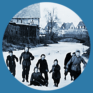
Erinnerungen-im-Netz.de :vf: · @erinnerungenimnetz
405 followers · 242 posts · Server hessen.social🗺️ #geoquiz
Wo in #Kassel wurde dieses #Foto aufgenommen? (#Geocode + Lösungsweg)
Bitte 🔃 drücken, damit Freunde miträtseln können!
Mögliche Lösungen mit einer CW 🚧 Klickbarriere versehen, damit andere weiterraten können. (closest #geodata wins) 🔍
@geoquiz @kassel
#nabu #osint #geolocation #geoint #maps #bienen 🐝
#geoquiz #kassel #foto #geocode #geodata #nabu #osint #geolocation #geoint #maps #bienen
Erinnerungen-im-Netz.de :vf: · @erinnerungenimnetz
405 followers · 241 posts · Server hessen.social🗺️ #geoquiz
Wo in #Kassel wurde dieses #Foto aufgenommen? (#Geocode + Lösungsweg)
Bitte 🔃 drücken, damit Freunde miträtseln können!
Mögliche Lösungen mit einer CW 🚧 Klickbarriere versehen, damit andere weiterraten können. (closest #geodata wins) 🔍
@geoquiz @kassel
#nabu #osint #geolocation #geoint #maps #bienen 🐝
#geoquiz #kassel #foto #geocode #geodata #nabu #osint #geolocation #geoint #maps #bienen

Justin · @justincolegis
335 followers · 33 posts · Server mapstodon.spaceWanted to share the next @GIS_SIG program on the NYS GIS Clearinghouse Updates (June 13). http://gis-sig.org/2023/04/27/nys-gis-clearinghouse-update/ #GIS #Geodata #Cartography

Jonatan Hildén · @jhilden
374 followers · 1819 posts · Server vis.socialHere Finland beats Sweden soundly when it comes to open geodata.
Sweden's Lantmäteriet has their most detailed 1m elevation model as ”by request only”, while Finland’s Maanmittauslaitos publishes their corresponding 2m model openly.
https://www.lantmateriet.se/en/geodata/geodata-products/product-list/terrain-model-download-grid-1/

Micha Silver · @Micha_Silver
49 followers · 60 posts · Server fosstodon.orgMaking global maps today’s a breeze.
Choosing data is picking cherries from the trees.
If it’s elevation that I need, SRTM is quite fine,
and average annual climate data from BioClim.
Cities, boundaries, population, open geodata, all for free.
#gischat #limrigis #srtm #geodata #bioclim
Erinnerungen-im-Netz.de :vf: · @erinnerungenimnetz
388 followers · 213 posts · Server hessen.social
🗺️ #geoquiz
Wo wurde dieses #Foto aufgenommen und welche Art von #Geocode ist gefragt? (Koordinaten + Lösungsweg)
Bitte 🔃 drücken, damit Freunde miträtseln können!
Mögliche Lösungen bitte mit einer CW 🚧 Klickbarriere versehen, damit andere weiterraten können. (closest #geodata wins) 🔍
@geoquiz @kassel @histodons
#osint #geolocation #kassel #geoint @cyb_detective
#geoquiz #foto #geocode #geodata #osint #geolocation #kassel #geoint
Erinnerungen-im-Netz.de :vf: · @erinnerungenimnetz
388 followers · 213 posts · Server hessen.social🗺️ #geoquiz
Wo wurde dieses #Foto aufgenommen und welche Art von #Geocode ist gefragt? (Koordinaten + Lösungsweg)
Bitte 🔃 drücken, damit Freunde miträtseln können!
Mögliche Lösungen bitte mit einer CW 🚧 Klickbarriere versehen, damit andere weiterraten können. (closest #geodata wins) 🔍
@geoquiz @kassel @histodons
#osint ##geolocation #kassel #geoint
#geoquiz #foto #geocode #geodata #osint #geolocation #kassel #geoint
Jonatan Hildén · @jhilden
370 followers · 1732 posts · Server vis.social
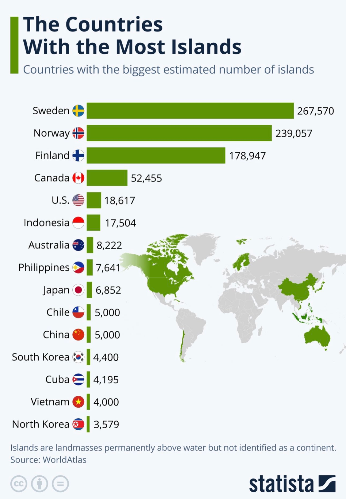
Interesting little factoid:
The Nordics took all the islands.
The source says WorldAtlas but I wonder how the numbers are arrived at? Perhaps just from counting shapes in vector geospatial file? The Finnish number is off by a fair amount, according to a 2018 survey Finland had all of 224,661 islands, 80% of them smaller than 100m2 however.
#geoData #maps
Link: https://julkaisut.valtioneuvosto.fi/bitstream/handle/10024/161269/2019_1_MMM_Saaristo_ja_vesistoaluepolitiikat_Euroopassa.pdf

Frédéric Cantat 🌍 · @CanFre
271 followers · 526 posts · Server mamot.fr
RT
🌐[Enquête] Devenez un acteur engagé en répondant à l’enquête inédite pour renforcer l'innovation, l'attractivité et la structuration d'une filière #géonumérique d'excellence avant le 23 mai : https://www.afigeo.asso.fr/filiere-geonum-enquete/
#geodata #geoentreprises #usages #emploi #ecosystème #ecolab
🐦🔗:https://twitter.com/afigeo_asso_fr/status/1650823082146234369
#geonumerique #geodata #geoentreprises #usages #emploi #ecosysteme #ecolab