
Amᵃᵖanda · @amapanda
1256 followers · 2074 posts · Server en.osm.townI have a ~ 8 GiB GeoJSON file. What's would you use to compress it? gzip is regular and fast, but not as space saving. Something installable via apt on debian
(and no cheeky answers like converting it out of geojson! 😛 I wanna know what The Cool Kids are using as compression tools now-a-days)
#gischat #geojson #unix

Dave Mackey · @davidshq
975 followers · 1772 posts · Server hachyderm.iolooking to #programmatically #transform data from a proprietary #XML format into an open #JSON format, #geojson to be specific.
any suggestions on good ways to proceed using #python?
Emphasis should be placed on the *transform* step (e.g., I can't simply convert the XML to JSON, I need to modify fields/values).
#programmatically #transform #xml #json #geojson #python #etl #question

Tykayn · @tykayn
1212 followers · 38546 posts · Server mastodon.cipherbliss.com
et hop, plus de 3000 bornes de recharge électriques intégrées (progressivement par zones et après vérification à la mano) dans osm grâce à mon mappeur de donnés geojson en provenance de du jeu de données datagouv vers #openstreetmap
https://forge.chapril.org/tykayn/scripts/src/branch/master/mapping_geojson_to_osm_tags
ce dépôt permet de mapper des propriétés de #geojson à partir d'une configuration en json qui va prendre et transformer les données selon des critères simples ou complexes, le tout en #nodejs et #typescript.
vous pouvez déjà créer vos propres fichiers de configuration de mapping. le script npm start vous montre comment personnaliser la commande de conversion.
on peut ensuite transformer le geojson en fichier osm à utiliser dans l'éditeur #josm avec geojsontoosm.
havez fun
#openstreetmap #geojson #nodejs #typescript #josm

Konstantin 🚀 · @konstantin
805 followers · 216 posts · Server social.headbright.eu
PostGIS is so cool, did you know you can just make it return rows as GeoJSON?
Say you have a table with an id, location and other columns. You can `SELECT ST_AsGeoJSON(t.*) FROM thetable AS t` and it will return niceley formatted #GeoJSON puttin all extra columns as "properties". Even the SRID of the location will be added 🤩

James Jefferies · @jamesjefferies
245 followers · 923 posts · Server mastodon.me.uk
Stuart :progress_pride: · @slowe
919 followers · 2202 posts · Server mastodon.me.uk
It is always a good idea to optimise your GeoJSON files if you are going to use them on the web. Often GeoJSON files can be bloated because GIS software will output ~15 decimal places on every coordinate. That is effectively to Angstrom accuracy - atomic scales! In a big GeoJSON file, as much as 40% of the file size can be due to entirely unnecessary precision. I've made a simple tool to help optimise #GeoJSON files at https://open-innovations.github.io/geojson-minify/

Sam Wilson · @samwilson
364 followers · 653 posts · Server wikis.worldSo it seems that I can do something a bit hacky with #Jekyll and have event pages be able to have #geojson files sitting next to their #Markdown ones, and the map will show them. I was too busy trying to make it work to ask anyone if this is what we want. Still, that's fun isn't it?

Kettwachsler · @phpmacher
1048 followers · 2986 posts · Server sueden.socialKonverter von #geojson nach #GPXwaypoints selbst schreiben, um die Inhalte diverser Dienste auf #Radreisen alle in meiner #Karte zu haben.
Was man eben so an einem WE macht...
#geojson #gpxwaypoints #Radreisen #Karte

ϺΛDИVTTΛH :fosstodon: · @madnuttah
241 followers · 1741 posts · Server fosstodon.org
With #zabbix #htmlagent and #grafana, there are also #environmental readings like #weather and #radiation now. I like it!
#zabbix #htmlagent #grafana #environmental #weather #radiation #geojson #json #opendata #homelab

· @linkdrop
53 followers · 1909 posts · Server botsin.spaceGeoJSON Utilities - Anzeige, Auswahl und Export von Verwaltungsgebieten in Deutschland http://opendatalab.de/projects/geojson-utilities/ #geojson #germany #utils #map

Nicolas Lambert 🌏 · @neocarto
810 followers · 85 posts · Server vis.socialFrom bertin@1.6.5, it is possible to rewind the geojson display in each layer using rewind = true #JSspatial #bertinjs #geojson

Cycling_mike · @cycling_mike
50 followers · 145 posts · Server mstdn.social
Coding Gardener · @cdavies
35 followers · 142 posts · Server mastodon.scotHaving incredible difficulty getting #RStats to read #spatial data types (shapefiles, kml); no idea how to convert area and length from a csv.
#GeoJSON file is taking forever to generate.
Shapefile works just fine in #QGIS, which makes me think it's an #R thing (perish the thought).
Don't know what else to try at the moment.
#r #qgis #geojson #spatial #rstats

Oli · @oli
247 followers · 1238 posts · Server social.tchncs.de
GitHub changed its awsome rendering of #geojson from #leaflet & #openstreetmaps to Microsoft Azure Maps and now nothings works anymore due to CORS and CSP. Not even the feedback button ... not even in Edge 🙄
Or is this just me?
https://github.com/olithissen/AwacsOrbitsDE/blob/main/awacs_orbits_de.geojson
#openstreetmaps #leaflet #geojson

Daniel Imfeld · @dimfeld
32 followers · 102 posts · Server techhub.socialNew geodata post is up! Covering topics such as
- Converting "shapefile" data into something web apps can actually use
- What is an SRID anyway and why should you care?
https://imfeld.dev/writing/loading_geographic_data_in_a_format_you_can_actually_use

Things Drawn By Text Models · @ThingsDrawnByTextModels
19 followers · 47 posts · Server hachyderm.io
"A map of the United States"
Polygons in GeoJSON
- ChatGPT 2023
NOTE: Only the green shaded areas were drawn by ChatGPT. The underlying map is just for reference.
#chatgpt #Maps #geojson #unitedstates #cartography
Things Drawn By Text Models · @ThingsDrawnByTextModels
19 followers · 46 posts · Server hachyderm.io
Daniel Imfeld · @dimfeld
31 followers · 94 posts · Server techhub.socialThe first article in my new series on geographic data is live. This one sets the stage for later topics by introducing GeoJSON.
https://imfeld.dev/writing/introduction_to_geojson

65dBnoise · @65dBnoise
1322 followers · 4119 posts · Server fosstodon.org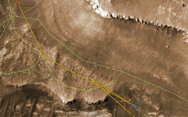
It looks like I've missed #Ingenuity having already flown its 42nd flight:
Using #QGIS with #HiRISE and #MMGIS #GeoJSON data from #NASA
#ingenuity #qgis #hirise #MMGIS #geojson #nasa #marshelicopter #mars2020 #solarocks #space
65dBnoise · @65dBnoise
1295 followers · 3975 posts · Server fosstodon.orgGreat map showing lighthouses in Europe, from the Geodienst researchers of Groningen University (https://www.geodienst.xyz/): https://geodienst.github.io/lighthousemap/
Project: https://github.com/geodienst/lighthousemap
The lighthouse data is in JSON format.
Here is a view of southern Europe. Location, color, pattern and area covered are all real.
h/t @Lambo 👍 !
#openstreetmap #lighthouse #geojson #map