
GregCocks · @GregCocks
612 followers · 555 posts · Server techhub.social
USGS Study Estimating A Monetary Value For Floodplain Ecosystem Services In The Chesapeake Bay And Delaware River Watersheds
--
https://www.usgs.gov/centers/chesapeake-bay-activities/science/floodplains-provide-millions-dollars-benefits-every-year <-- shared technical article
--
https://doi.org/10.1016/j.jenvman.2023.118747 <-- shared paper
--
#GIS #spatial #mapping #model #modeling #spatialanalysis #spatiotemporal #flood #flooding #floodinnundation #innundation #extremeweather #climatechange #watersheds #floodengineering #floodplains #nutrients #sediments #sedimentation #fluvial #soils #erosion #floodwaters #agriculture #farming #economics #accounting #mitigation #tradeoffs #management #landforms #geomorphology #ecosystems #publicsafety #communityhealth #appliedscience #water #hydrology #benefits #benefitstransfer #regulation #quantification #value #loss #lossanddamage #lossadjusting #Hazus #ChesapeakeBay #DelawareRiver
@usgs
#gis #spatial #mapping #model #modeling #spatialanalysis #spatiotemporal #flood #flooding #floodinnundation #innundation #extremeweather #climatechange #watersheds #floodengineering #floodplains #nutrients #sediments #sedimentation #fluvial #soils #erosion #floodwaters #agriculture #farming #economics #accounting #mitigation #tradeoffs #management #landforms #geomorphology #ecosystems #publicsafety #communityhealth #appliedscience #water #hydrology #benefits #benefitstransfer #regulation #quantification #value #loss #LossAndDamage #lossadjusting #hazus #ChesapeakeBay #delawareriver
GregCocks · @GregCocks
604 followers · 545 posts · Server techhub.social
World's Beaches Are Changing Because Of Climate Change
--
https://theconversation.com/worlds-beaches-are-changing-because-of-climate-change-green-thinking-is-needed-to-save-them-211953 <-- shared article
--
https://doi.org/10.1080/03736245.2023.2193565 <-- shared paper
--
#GIS #spatial #mapping #anthropogenic #climatechange #coast #coastline #coastalprocesses #greeninfrastructure #sandybeaches #beaches #mitigation #coastalengineering #coastalcommunities #mangroves #rockyshorelines #rivers #estuaries #hydro #water #hydrospatial #sanddunes #landforms #geomorphology #sealevel #SLR #sealevelrise #Anthropocene #sediment #sedimentation #innundation #erosion #protection #urbanisation #landusechange #landuseplanning #planning #resilience #ecosystems #environmental #solutions #ecology #southafrica
#gis #spatial #mapping #anthropogenic #climatechange #coast #coastline #coastalprocesses #greeninfrastructure #sandybeaches #beaches #mitigation #coastalengineering #coastalcommunities #mangroves #rockyshorelines #rivers #estuaries #Hydro #water #hydrospatial #sanddunes #landforms #geomorphology #sealevel #slr #sealevelrise #anthropocene #sediment #sedimentation #innundation #erosion #protection #urbanisation #landusechange #landuseplanning #planning #resilience #ecosystems #environmental #solutions #ecology #southafrica

Stéphane Baize · @Stef_EQ_Geology
148 followers · 61 posts · Server mastouille.fr#rockfall yesterday in the Maurienne Valley, french #Alps 🇫🇷, causing the cut of roads to Italy 🇮🇹.
The relation to the #permafrost melting, as suggested in the paper, is questionable because of low elevation of the event…
But any impact from the heavy rains of past days?
#geomorphology
#rockfall #Alps #permafrost #geomorphology
Stéphane Baize · @Stef_EQ_Geology
148 followers · 60 posts · Server mastouille.fr
Ecroulement rocheux hier en vallée de #maurienne entraînant la coupure des voies de communication vers l’Italie.
La relation avec la fonte du #permafrost, comme suggéré dans l’article ci-dessous, me paraît assez douteuse compte tenu de l’altitude de l’événement.
En revanche, une relation avec les précipitations des derniers jours?
#maurienne #permafrost #geomorphology

Martin Rutzinger · @mrutzinger
122 followers · 69 posts · Server techhub.social
Quantifying slope movements: Tree trunk tracking using long-range stationary 4D laser scanning point clouds #remotesensing #landslides #timeseries #geomorphology
#remotesensing #landslides #TimeSeries #geomorphology
Stéphane Baize · @Stef_EQ_Geology
146 followers · 57 posts · Server mastouille.fr
GregCocks · @GregCocks
598 followers · 530 posts · Server techhub.social
Earth's Retreating Glaciers Are Creating Huge Alien Ecosystems | Future Emergence Of New Ecosystems Caused By Glacial Retreat
--
https://interestingengineering.com/science/earths-glaciers-50percent-alien-habitats <-- shared technical article
--
https://doi.org/10.1038/s41586-023-06302-2 <-- shared paper
--
#GIS #spatial #mapping #spatialanalysis #remotesensing #glacial #postglacial #glacier #glaciers #retreat #melting #snowandice #landscape #landform #geomorphology #geomorphometry #anthropogenic #climatechange #ecosystems #glaciershrinkage #meltingglaciers #cascading #consequences #impacts #humanimpacts #global #analyses #deglaciated #model #modeling #spatiotemporal #ecology #biodiversity #freshwater #waterresources #water #hydrology #mitigation #protection
#gis #spatial #mapping #spatialanalysis #remotesensing #glacial #postglacial #glacier #glaciers #retreat #melting #snowandice #landscape #landform #geomorphology #geomorphometry #anthropogenic #climatechange #ecosystems #glaciershrinkage #meltingglaciers #cascading #consequences #impacts #humanimpacts #global #analyses #deglaciated #model #modeling #spatiotemporal #ecology #biodiversity #Freshwater #waterresources #water #hydrology #mitigation #protection
GregCocks · @GregCocks
583 followers · 522 posts · Server techhub.social
Mountains Are Collapsing - A Swiss Mountain Peak Fell Apart, Sending 3.5 Million Cubic Feet Of Rock Into The Valley Below - Scientists Warn Climate Change Could Make More Mountains Crumble.
--
https://www.businessinsider.com/mountains-switzerland-collapsing-from-permafrost-melt-2023-8 <-- shared media article
--
#GIS #spatial #mapping #model #modeling #prediction #geology #engineeringgeology #massmovement #global #landslide #debrisflow #mudslide #mountain #cryosphere #glacier #snow #ice #permafrost #water #hydrology #rockfall #EuropeanAlps #europe #SouthernAlps #newzealand #andes #peru #indigeneous #firstnation #risk #hazard #publicsafety #climate #melting #snowandicemanagement #climatechange #landforms #change #geomorphology #globalwarming #IPCC #naturalhazard #geologichazards
#gis #spatial #mapping #model #modeling #prediction #geology #engineeringgeology #massmovement #global #landslide #debrisflow #mudslide #mountain #cryosphere #glacier #snow #ice #permafrost #water #hydrology #rockfall #europeanalps #Europe #southernalps #newzealand #Peru #indigeneous #firstnation #risk #hazard #publicsafety #climate #melting #snowandicemanagement #climatechange #landforms #change #geomorphology #globalwarming #ipcc #naturalhazard #geologichazards #andes
GregCocks · @GregCocks
576 followers · 516 posts · Server techhub.social
The Impact Of Vegetation On Meandering Rivers
--
https://doi.org/10.1038/s43017-021-00249-6 <-- shared paper
--
#GIS #spatial #mapping #hydrology #river #meanders #anthropocene #vegetation #processmodeling #model #modeling #plants #trees #carboncycle #Palaeozoic #evolution #fluvial #fluvialgeomorphology #geomorphology #channel #channelisation #rivergeomorphology #impact #humanimpact #climatechange #climate #carbondioxide #anthropogenic #changes #biodiversity #aridification #dynamics #geology #soilscience #riverbanks #erosion #sedimentation #floodplain #urbanisation #deforestation #pollution #ancient #landscape #watershed #biogeochemistry #morphometry #geomorphometry
#gis #spatial #mapping #hydrology #river #meanders #anthropocene #vegetation #processmodeling #model #modeling #Plants #trees #carboncycle #palaeozoic #evolution #fluvial #fluvialgeomorphology #geomorphology #channel #channelisation #rivergeomorphology #impact #humanimpact #climatechange #climate #carbondioxide #anthropogenic #changes #biodiversity #aridification #Dynamics #geology #soilscience #riverbanks #erosion #sedimentation #floodplain #urbanisation #deforestation #pollution #ancient #landscape #Watershed #biogeochemistry #morphometry #geomorphometry
GregCocks · @GregCocks
576 followers · 515 posts · Server techhub.social
The Kingdom of Bhutan [1965 cartography]
--
https://collections.lib.uwm.edu/digital/collection/agdm/id/30617/rec/61 <-- link to map and details
--
https://doi.org/10.1111/j.1467-8306.1965.tb00539.x <-- shared paper’s note, 2010
--
H/T @evan Applegate
[a “yam between two boulders.” (China (Tibet) and India)]
“Contained in (work): Association of American Geographers Annals of the Association of American Geographers…
Relief shown by shading and spot heights…”
#GIS #spatial #mapping #bhutan #kingdomofbhutan #map #cartographer #cartography #topography #relief #transportation #seasia #hydrology #historic #historicmaps #landform #geomorphology #terrain #gischat #AAG
@americangeo
#gis #spatial #mapping #bhutan #kingdomofbhutan #map #cartographer #cartography #topography #relief #transportation #seasia #hydrology #historic #historicmaps #landform #geomorphology #terrain #gischat #aag
GregCocks · @GregCocks
553 followers · 490 posts · Server techhub.social
Perspectives - A Bird’s-Eye View Of Landscapes [Sweden]
--
https://iexposure.ikfoundation.org/perspectives <-- shared technical article
--
#GIS #spatial #mapping #remotesensing #aerial #satellite #drone #imagery #history #archaeology #urban #industrial #agriculture #iBIRDSEYE #Sweden #records #landforms #geomorphology #examples #usecases #appliedscience #ancientmonuments #burial #burialmounds #overview #SouthernSweden #spatialanalysis #landcover #landuse
#IKFoundation #SwedishNationalArchives
#gis #spatial #mapping #remotesensing #aerial #satellite #drone #imagery #history #archaeology #urban #industrial #agriculture #ibirdseye #sweden #records #landforms #geomorphology #examples #usecases #appliedscience #ancientmonuments #burial #burialmounds #overview #southernsweden #spatialanalysis #landcover #landuse #ikfoundation #swedishnationalarchives
GregCocks · @GregCocks
544 followers · 488 posts · Server techhub.social
At What Scales Does A River Meander? Scale-Specific Sinuosity (S3) Metric For Quantifying Stream Meander Size Distribution
--
https://doi.org/10.1016/j.geomorph.2023.108734 <-- shared paper
--
“HIGHLIGHTS:
• Scale-specific sinuosity (S3) summarizes bend sizes of linear features and associated contributions to sinuosity across a range of scales.
• The S3 plot is analogous to a frequency histogram of bend sizes, like a fingerprint or a spectral signature
• The S3 is an easily computed metric to assess influential scales in bend patterns of linear stream features
• The paper formalizes a relation between sinuosity and fractal dimension..."
#GIS #spatial #mapping #multiscale #water #hydrography #streamgeometry #meanderpattern #meander #fractaldimension #sinuosity #model #modeling #spatialanalysis #bends #distribution #S3 #fractals #geometry #landscape #geomorphology #geomorphometry #prediction #spatialanalysis #coast #coastal #automatedanalysis #riverbend #appliedscience
#gis #spatial #mapping #multiscale #water #hydrography #streamgeometry #meanderpattern #meander #fractaldimension #sinuosity #model #modeling #spatialanalysis #bends #s3 #fractals #geometry #landscape #geomorphology #geomorphometry #prediction #automatedanalysis #riverbend #appliedscience #distribution #coast #coastal

RaoulTC · @raoultc
15 followers · 200 posts · Server piaille.fr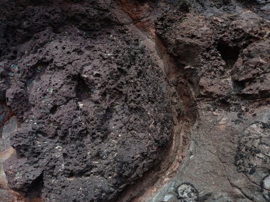
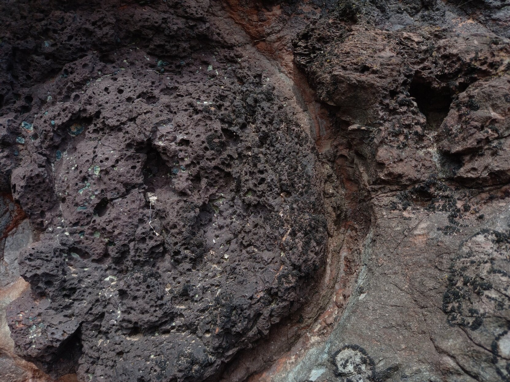
Dynamique des ruissellements basaltiques tertiaires et erosion des massifs secondaires. Vous avez 4 heures.
C'était sur une plage, au nord de Montrose, c'était joli, aussi.
Dynamics of tertiary basaltic runoff and erosion of secondary massifs. You have 4 hours.
It was on a beach, north of Montrose, it was pretty, too...
#geomorphology #geology #geomorphologie #geologie #scotlandisbeautiful
#geomorphology #geology #geomorphologie #geologie #scotlandisbeautiful

David Litwin · @davidglitwin
140 followers · 11 posts · Server fediscience.org
Earlier this summer I came across this stream with deposits of leaves more than 50 cm deep adjacent to the channel. Has anyone seen this before? Is this #leaf #geomorphology?
GregCocks · @GregCocks
398 followers · 433 posts · Server techhub.social
Geomorphometry - A Brief Guide
--
https://doi.org/10.1016/S0166-2481(08)00001-9 <-- shared paper
--
https://geomorphometry.org/ <-- International Society for Geomorphometry home page
--
#GIS #spatial #mapping #elevation #remotesensing #data #digital #civilengineering #science #visualization #geometry #military #algorithms #society #visualisation #model #modeling #geomorphology #landcover #geomorphometry #quantitative #landsurface #analysis #spatialanalysis #spatiotemporal #terrainanalysis #physicalgeography #geography #geology #topography #landforms #watersheds #surfacemodel #algorithms #interpretation #gischat
#gis #spatial #mapping #elevation #remotesensing #data #digital #civilengineering #science #visualization #geometry #military #algorithms #society #visualisation #model #modeling #geomorphology #landcover #geomorphometry #quantitative #landsurface #analysis #spatialanalysis #spatiotemporal #terrainanalysis #PhysicalGeography #geography #geology #topography #landforms #watersheds #surfacemodel #interpretation #gischat
GregCocks · @GregCocks
398 followers · 433 posts · Server techhub.social
AGU23 Session Submittal Requests - Flash Floods and Debris Flows After Wildfire - Process Understanding to Hazard Assessment
--
https://agu.confex.com/agu/fm23/prelim.cgi/Session/186554 <-- make submittal
--
“Do you work in postfire hazards? Consider presenting in our AGU 2023 session, "Flash Floods and Debris Flows after Wildfire." The abstract submission deadline is Wednesday, August 2nd!..” ~ Matthew A. Thomas, USGS
#GIS #spatial #mapping #callforsubmissions #research #results #AGU #AGU23 #conference #paper #submittals #floods #massmovement #engineeringgeology #flashflood #flooding #debrisflow #naturalhazards #riskhazard #risk #hazard #assessment #postfire #wildfire #bushfire #forestfire #fire #climatechange #extremeweather #urban #urbancorridors #mitigation #water #hydrology #model #modeling #geomorphology #meteorology #weather #rainfall #precipitation #publicsafety #monitoring #forecasting #gischat #remotesensing #process #processes #AGU #AGU23
@AGU
#conference #paper #gis #spatial #mapping #callforsubmissions #research #results #AGU #agu23 #submittals #floods #massmovement #engineeringgeology #flashflood #flooding #debrisflow #NaturalHazards #riskhazard #risk #hazard #postfire #wildfire #bushfire #forestfire #fire #climatechange #extremeweather #urban #urbancorridors #mitigation #water #hydrology #model #modeling #geomorphology #meteorology #weather #rainfall #precipitation #publicsafety #monitoring #forecasting #gischat #remotesensing #assessment #process #processes

Bruce MacDonald · @rationaldoge
289 followers · 2310 posts · Server hachyderm.io
The ground is still moving in Rolling Hills Estates in California…
"By Monday morning, multiple homes had slid down the hillside that borders the southeast side of the street, dipping below what was left of their driveways, some almost completely hidden from the road they previously lined.
"Garage doors were almost flattened, roofs had caved in, massive crevices exposed beams and pipes. Many of the homes were already gone." #geomorphology
https://www.latimes.com/california/story/2023-07-10/homes-damaged-rolling-hills-estates-ground-movement

RaoulTC · @raoultc
12 followers · 155 posts · Server piaille.fr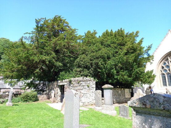
À la rencontre de l'If de Fortingal, un des arbres les plus vieux du monde. Probablement plus de 5000 ans. On ne reste pas de marbre devant une vie aussi longue, surtout quand on a étudié l'Holocène...
Meet the Fortingal Yew, one of the oldest trees in the world. Probably more than 5000 years old. We don't remain unmoved by such a long life, especially when we have studied the Holocene...
#ecosse #scotland #tree #arbres #archaeology #dendrochronology #geomorphology

Archéosciences Bordeaux · @archeosciences
24 followers · 45 posts · Server archaeo.socialNew publication: "Measuring and evaluating colorimetric properties of samples from loess-paleosol sequences" #OpenAccess #Geoscience #Climatology #Geomorphology #Stratigraphy #Geography https://doi.org/10.1016/j.mex.2023.102159
#openaccess #geoscience #climatology #geomorphology #stratigraphy #geography
Mike Malaska · @mike_malaska
589 followers · 524 posts · Server deepspace.socialSo this is all good for #geomorphology and #geology, but what about #astrobiology?
Well, that impact created fissures. Fun little new interfaces that micobes could colonize.
And places where different rock material got mixed (like sandstone getting dragged through basalt).
The impact itself might have been a bummer moment (2-4 GPa!!!), but afterwards with those fluids mixing nutrients (like metal ions for rock-eating bacteria) and different materials around make grat places to look for life!
#geomorphology #geology #astrobiology