
Joseph Elfelt · @mappingsupport
541 followers · 482 posts · Server m.ai6yr.org
1/3 Got 3D?
#GoogleEarthPro is free software that simulates 3D. It can be installed on PC/Mac/Linux. In addition to the screen controls you can rightclick-hold and slowly move your pointing device.
Here are example #GIS KMZ files for Ventura County, CA.
Trails and roads. Transparent background.
https://mappingsupport.com/p2/kmz_demo/ventura_county_all.kmz 21MB
Trails and roads. Scanned USGS topos.
https://mappingsupport.com/p2/kmz_demo/ventura_county_all_topo.kmz 37MB
#googleearthpro #gis #georeference #georeferencing #geospatial #maps #mapping

Skora, Will · @wills
307 followers · 264 posts · Server mastodon.xyzresuming a project after *sees last modified date of text file with my notes* over 4 years ??!? (at least!?!) (#georeferencing historic aerial imagery & sanborn maps to make a zoomable web map out of it. (i last blogged about it at https://skorasaur.us/2018/04/georeferencing_the_past/) #map #geochat #gischat
eager to pick it back up.
#georeferencing #map #geochat #gischat

Anita Graser 🇪🇺🇺🇦 · @underdarkGIS
2180 followers · 1245 posts · Server fosstodon.org

Norbert Holstein · @dr_norb
1121 followers · 836 posts · Server fediscience.org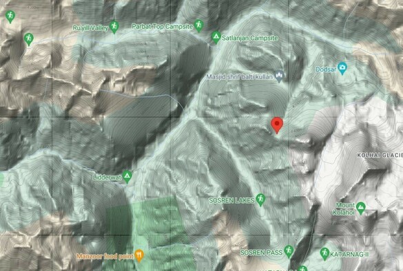
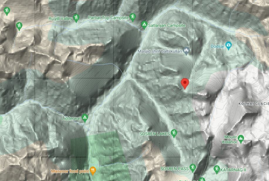
At the #NaturalHistoryMuseumLondon, we are not only imaging our collections, we also do #georeferencing. Amazingly, the more we digitise, the more data we get, and we can even reconstruct travel routes.
E.g.; Oleg #Polunin (https://bionomia.net/Q266663) collected in the "Kolahoi valley", #Kashmir, in 8/1956.
He started his travel from Pahalgam in the south, via Liddarwat (now a camping ground) towards a "pass" on 14422 ft. altitude where Polunin collected several plants.
#kashmir #polunin #georeferencing #naturalhistorymuseumlondon

Chrono Matthias · @chronohh
259 followers · 243 posts · Server norden.social
3 mins of fame for Chronoscope World at #IIIF online meeting 2022
Video: https://youtu.be/6Xb0i8ukSKk?t=1876
Chronoscope World: https://mprove.de/chronoscope/world.html
#iiif #georeferencing #oldmaps
Chrono Matthias · @chronohh
259 followers · 243 posts · Server norden.social
@Ustinoff Nein, nicht mit meiner Methode. Ich zuppele an den vier Ecken bis es so einigermaßen… Und dann hängt es am Carthographen und dem Maßstab, ob es passt.
Auf der anderen Seite will man ja auch kein Hubbabubba https://www.flickr.com/photos/mprove/32424779033/in/datetaken-public/
#rectification #georeferencing #oldmaps

Chris Levesque · @chris_levesque
728 followers · 430 posts · Server zirk.usI'm considering a project using StoryMapJS to visually display some of the incidents I wrote about in my dissertation. Does anyone know where I could find georeferenced maps of South Vietnam from 1965-1973?
#georeferencing #vietnamwar #HistoricalMaps

Julien M. · @julm
485 followers · 4935 posts · Server framapiaf.org#BlenderGIS
> Grab geodata directly from the #web : display dynamics web #maps inside #Blender 3D view, requests for #OpenStreetMap data, get true #elevation data from the #NASA #SRTM mission.
> Manage #georeferencing informations of a scene, compute a terrain mesh by #Delaunay triangulation, drop objects on a terrain mesh, make terrain analysis using shader nodes, setup new cameras from geotagged #photos, setup a camera to render with #Blender a new georeferenced raster.
https://github.com/domlysz/BlenderGIS
#photos #delaunay #georeferencing #srtm #nasa #elevation #openstreetmap #blender #maps #web #BlenderGIS