Peter Stoyko · @peter
223 followers · 237 posts · Server stoyko.spaceHISTORY + VISUALIZATION. A 3D recreation of the Aztec capital of Tenochtitlan. It includes slider comparisons with present day CDMX.
#visualization #urbanism #history #geoviz
Florian Ledermann · @floledermann
545 followers · 239 posts · Server mapstodon.spaceNew month, new edition of my list of Mastodon accounts for #cartography, #gis and #geoviz (~170 accounts reviewed, 53 accounts added to the list)
New recommendations for #cartography (1/2):
@alexsingleton@mapstodon.space
@andrewfrench@fosstodon.org
@bdon@mastodon.social
@chronohh@norden.social
@eldang@mapstodon.space
@geoObserver@mastodon.social
@julgaf@mapstodon.space
@mapologies@mastodon.social
@mizmay@mapstodon.space
@mthv@fosstodon.org
#cartography #GIS #geoviz #followfriday #ff
Florian Ledermann · @floledermann
261 followers · 189 posts · Server mapstodon.spaceI spent way too much time on this 🙈:
A curated list of Mastodon accounts to follow if you're interested in #cartography, #maps, #geoviz'ualisation, visual aspects of #GIS and #geography etc.
Maybe a good way to get your feed going if you are #newhere…
https://cartolab.at/cartography-on-mastodon/
Let me know if you want to be included/removed or feel misrepresented. #gischat
#cartography #maps #geoviz #GIS #geography #newhere #gischat
Françoise Bahoken · @fbahoken
388 followers · 160 posts · Server mapstodon.space✨Ma vie de CR en carto dans l’ESR
➡️ impression d’avoir gagné une bataille ce jour, en faisant inscrire les #cartostats #géoviz #data #application #geoweb pour #transports #mobilités comme **objet de recherche** de mon labo AME-Splott à l’Univ. Gustave Eiffel
🔥🧐🔥
🗳 Vote à main levée pour départager les vives discussions à 7 voix pour contre 6
🔥🤪🔥😅
Je rappelle que je suis arrivée là bas en décembre 2010. 😅
#cartostats #geoviz #data #application #geoweb #Transports #mobilites
Benjamin Hennig · @geoviews
433 followers · 33 posts · Server mapstodon.spaceTomorrow's weather: Creating a global weather map in R https://dominicroye.github.io/en/2023/tomorrows-weather/
#geography #maps #weather #R #geovisualisation #geoviz
#geography #maps #weather #r #geovisualisation #geoviz
Françoise Bahoken · @fbahoken
377 followers · 139 posts · Server mapstodon.spaceSalut les masto. de la #geoviz #formation #enseignement #territoires 🌟 🌍 💚
La Session N du futur colloque du CIST 2023 est dédiée à la #géovis de #bigdata pour la compréhension des #territoires via les #formations & enseignements.
➡️ N'hésitez pas à proposer une communication 🙂
🔗 https://cist2023.sciencesconf.org/resource/page/id/24
➡️ Session organisée avec @comeetie et Mericskay
#geoviz #formation #enseignement #territoires #geovis #bigdata #formations
Jonathan Lenoir · @jonlen
229 followers · 317 posts · Server ecoevo.socialRT @JohannesHUhl1@twitter.com
Animating #map distortions: Transverse #Mercator #projection of each #UTM zone applied to the globe. Made in #python using #pyproj, #geopandas, #shapely, #matplotlib, and #PIL. #cartography #geospatial #geoviz #dataviz #gischat #gis #geopython #geovisualization #mapping
🐦🔗: https://twitter.com/JohannesHUhl1/status/1611885483252142081
#map #mercator #projection #utm #python #pyproj #geopandas #shapely #matplotlib #PIL #cartography #geospatial #geoviz #dataviz #gischat #gis #geopython #geovisualization #mapping
Françoise Bahoken · @fbahoken
363 followers · 125 posts · Server mapstodon.space[Rappel]✨🗓️🗺️🎁✨Journée d'études de l'Action de recherche (Carto)graphies et (Géo)visualisation de données du GdR Magis
➡ Rennes - 6 janvier 2023
🔗En savoir plus https://github.com/magisAR9/JEGeovizRennes
#spatialdata #covoiturage #flux #flowmap #cartostats #geoviz
#spatialdata #covoiturage #flux #flowmap #cartostats #geoviz
Nicolas Lambert 🌏 · @neocarto
541 followers · 20 posts · Server vis.socialHow to design a dashboard with @observablehq plot & #bertinjs? #javascript #dataviz #geoviz https://observablehq.com/@neocartocnrs/dashboard-with-bertin-plot
#geoviz #dataviz #javascript #bertinjs
Nicolas Lambert 🌏 · @neocarto
508 followers · 10 posts · Server vis.social[REPLAY] Presentation of @observablehq for the INSEE data-scientists network (in french 🇫🇷). Thanks to @linogaliana for the invitation. #DataViz #GeoViz #JSspatial #Observablehq #Javascript #Cartography https://ssphub.netlify.app/talk/presentation-dobservable-par-nicolas-lambert/
#cartography #javascript #observablehq #JSspatial #geoviz #dataviz
P.-O. Mazagol · @POMazagol
245 followers · 35 posts · Server mapstodon.spaceRappel : C'est ce jeudi ! Les inscriptions en présentiel sont closes. Mais un accès à distance est proposé !
Séminaire international "Héritages culturels et outils numériques".
Programme et paramètres de connection sont disponibles ici : https://perso.univ-st-etienne.fr/mazagolp/seminaires/seminaire_hc_et_numerique_2022.html
#GIS #SIG #map #cartographie #geoviz #paysage #landcape #mémoire #3D #sig #patrimoine #culturalheritage #gischat
#GIS #sig #map #cartographie #geoviz #paysage #landcape #memoire #3d #patrimoine #culturalheritage #gischat
Raf · @Raf
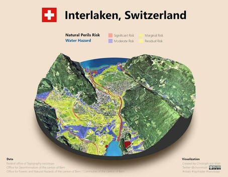
298 followers · 5913 posts · Server mastodon.socialRT @chvonmatt@twitter.com
Mapping time! 🙂
This scene shows a risk map of water-related natural perils for #Interlaken, #Switzerland.
Map: #rayshader / #rstats
Preprocessing (work-around): #QGIS
Data: @swisstopo@twitter.com & @kanton_bern@twitter.com
Layouting: #Inkscape & #GIMP
#rstats #geoviz #dataviz #gismapping #QGIS
🐦🔗: https://twitter.com/chvonmatt/status/1520815311108272128
#interlaken #switzerland #rayshader #rstats #qgis #inkscape #gimp #geoviz #dataviz #gismapping


